
Cetate (Timișoara)


.jpg)


Cetate ( German Inner City , Hungarian Belváros ) is a historic quarter, the I. District and the center of the western Romanian city of Timișoara ( German Timişoara ). The district occupies an area of 480 hectares.
The term is also used for the Temesvár fortress, which formerly lies within the boundaries of today's district , of which essentially only the Maria Theresa bastion has survived.
history
The name of the district Cetate ( German fortress, castle , Latin Castrum Timensiensis ) refers to the different fortifications that have existed at this point over the centuries in various forms and under changing rule. It is believed that the fortress was built in Avar architecture as early as the 10th century and, surrounded by moats, was located on the site of today's National Theater and Opera House of Timișoara .
After defeating the Wallachian ruler Achtum the region of the first Hungarian king was Stephen I in the Kingdom of Hungary added. The fortress has been documented as Castrum Regius Temesvar since 1212 with a document issued by the Arpádic King Andreas II of Hungary .
In 1241 the Mongols invaded from the north and devastated the Banat . After their expulsion, the Hungarian King Béla IV called German settlers to the depopulated country, who rebuilt the fortress. The earth and stone walls of the fortress were fortified with lime-bound stones and bricks, and the moats deepened and widened.
In 1307 Charles I of Hungary gave instructions to build a new royal fortress. The Begh ( Bega - at that time also Little Temesch ) branched out into three arms, the middle of which flowed along today's Strada Alba Iulia . The Temewar fortress from the Árpád era stood between the central and western arms. Charles I left the existing fortress out of earth and arranged for a new fortress to be built out of rock between the central and eastern arms, which temporarily led to two fortresses. On this island, Charles I had his royal castle built until 1315, one of the strongest fortifications of the Middle Ages, which Charles I made his seat of government for almost eight years. This building was the basis for the later Hunyadi Castle . After his death in 1342, the royal palace became the property of the crown.
The fortress lost its importance for the time being, and after an earthquake its walls were exposed to decay for a time. Due to the threatened expansion of the Ottoman Empire into Europe and the use of gunpowder , the fortifications were adapted to the current state of war technology in the following years. Strong oak trunks were used to build the walls and palisades were built, which were surrounded by two to three moats. The walls were equipped with loopholes and the defensive towers were manned with cannons.
Under the rule of the later Roman-German emperor Sigismund von Luxemburg from 1387–1437, the castle was repaired by Pippo Spano di Ozora . At that time the defense structure was surrounded by earth walls and palisades. The fortress had four gates: the Lippa Gate (“Praiko”), the Transylvanian Gate , the Arad Gate and the Water Tower Gate . All the houses in the market town were made of wood or clay mixed with chaff. The development of the suburbs Small and Large Palanka , which were surrounded by palisades, began.
On June 5, 1443, the area was shaken again by a devastating earthquake. The fort and the walls of the fortress were badly damaged and partially destroyed by the tremors. The Obergespan Johann Hunyadi had the fort and the fortress walls rebuilt by the architect Paolo Santini da Duccio , the construction work on the fort lasted from 1443 to 1447. The defensive structures were adapted to the war techniques that had changed due to the development of gunpowder. Old throwing machines were replaced by cannons. The Anjou Fort, which was badly damaged by the earthquake, was removed and the new Hunyadi Palace was erected across the floor plan of Charles I's fort. The building was equipped with several bastions and cannons and provided with three gates, one in the east, one in the west and one in the north. The new fortress walls were provided with defensive towers in the north and north-east, and double moats were dug in front of them. Oak palisades were erected in the south and west, where the fortress met the Bega marshes. Only the foundation stones and the water tower remain of the old Anjou fortress. The new fortress walls ran along today's Strada Marasești , Strada Eugeniu-de-Savoya and Strada Bocsa , to the southeast along the later Transylvanian barracks , and to the south they surrounded Hunyadi Castle.
The two suburbs of Große Palanka in the west and Kleine Palanka in the east were also reinforced with palisades, earth walls and moats. The stone material required for the construction of the defense was brought from the Werschetz Mountains, sand and gravel came from Lipova , and the necessary wood from the nearby forests. Wallachians and Serbs who had settled in the area of today's factory town served as workers.
After taking office in 1490, King Vladislav II decided to re-fortify the Cetate. This was supervised by the Comes Pál Kinizsi , who also provided parts of his own assets for this purpose. At that time, the Cetate was considered one of the strongest fortresses. It could only be attacked from the north and the west. The other sides were protected by the Bega marshes. The cetate of that time consisted of three parts: the castle, the residential areas, and the island, the Little Palanka in the east. Outside the fortress walls was the Great Palanka to the west. The water tower, the most important defense structure of the fortress, was located between the fort and the residential areas. The path that connected the fort with the residential areas via a bridge also led through this. Hunyadi Castle was surrounded by solid walls and moats.
After it was captured by the Ottomans in 1552, the fortress was in a very poor condition as the walls were badly damaged by cannon fire. Casim Pascha immediately began repairs, for which he rounded up Wallachians from the neighboring villages for forced labor. The city's churches have been converted into mosques . There were still no cobbled streets in the cityscape, mostly the mud was covered with boards. Most of the houses were made of wood. The houses of prayer, the powder tower, the mill and some administrative buildings were built from bricks in the oriental style.
Around 1642/1643 the Cetate was fortified again by a captured German architect. Andrea Cornaro from Crete was entrusted with the renovation of the fortifications and the canalization of an arm of the Bega.
A detailed description of the Cetate in 1660 comes from the Ottoman Evliya Çelebi and dates:
“Tamisvar lies in the marshes of the Tamis River, like a turtle in the water. Its four legs are the four large bastions, but the inner castle fort is its head. Their shape is five-angled. There are neither bricks nor stones in it, because it is a fortress made of thick oak trunks clad with woven fences. The skilled builder made this fence out of wild vines, covered it with plaster and lime, so that a white castle was created. The wall is fifty feet thick, in some places even sixty. All around is a deep moat, and in three places there are guard rooms overlooking the moat. Every evening nine music bands play and all the guards call each other from time to time throughout the night: 'Allah akbar!'. The fortress has no shooting hatches and no defense turrets, but it does have many cannon slots. In all there are 200 fine cannons. The number and quantity of the war implements as well as the food and food stored in the fortress is known only to the exalted God. On the ramparts, the fortress can be bypassed in an hour. "
The fortress had five gates at the time, two of which, in the south and east, were named Azab . In addition there were the gates of the rooster (after the weathercock on it) in the north, the water and the bank. The Cetate, with 1200 houses, was divided into four residential districts and had ten suburbs with another 1500 houses.
After the recapture by the Habsburgs in 1716, the fortress was redesigned between 1723 and 1765 in the Vauban style , which was modern at the time . The new fortress replaced the older and smaller Ottoman citadel and consisted of nine bastions, of which only four other smaller wall fragments exist in addition to the Maria Theresa Bastion , which was built from bricks between 1730 and 1735 and encompasses around 1.7 hectares of today's city center . namely on Strada Alexandru Ioan Cuza , in the Botanical Garden of Timișoara and on Piața Timișoara 700 - there once north and once south of Strada Coriolan Brediceanu. Under the leadership of Governor Claudius Florimund Mercy , the Bega Canal was built from 1728, which drained the swamps of the surrounding area.
After the Hungarian Revolution of 1848/1849 , the castle and the fortifications lost their importance, so that the walls and the castle gates were demolished. With the town planning plans, the Cetate became the city center of what was then Temesvár from 1895, which was connected to the suburbs in 1989 by 40-meter-wide first-class traffic arteries such as today's Bulevard Tinereții or Bulevard Revoluției . The dense, straight-angled street network in the city center was surrounded by a ring road based on the Viennese model . By 1910 the outer districts merged with the area of the Cetate to form a closed cityscape. The bombing and fighting in Timișoara during the Second World War did not have any major consequences for the building fabric of Cetates.
The Transylvanian barracks, which was built between 1719 and 1723 and with its 483 meters length, was the longest building in Europe, was demolished in 1964 during the communist dictatorship. The structure of Cetates suffered from a lack of maintenance during this time. New investments in the renovation of the often ailing buildings after the Romanian Revolution in 1989 had a positive effect on the new appearance of the city; however, there is still a need for action.
Attractions
Squares, buildings, statues (selection)

Piața Victoriei

Piața Unirii

Piața Libertății

Piața Dr. IC Brătianu

Hunyadi Castle

Victor Babes Medical and Pharmaceutical University


Parks
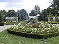
Freilichtbühne-Rosenpark, 2010

Parcul Civic


On the originally undeveloped foreshore between the fortress and the Bega, spacious parks were created, including (from west to east) Parcul Central, Parcul Catedralei, Parcul Rozelor , and Parcul Copiilor. Furthermore, there is the Parcul Civil in the center and the Parcul Botanic in the northwest of the district.
bridges
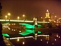
Podul Tinereții at night


The following bridges cross the Bega and connect the inner city with other districts of Timișoara (from west to east):
|
|
literature
- Hans Gehl : German urban languages in provincial cities of Southeast Europe, illustrated edition 95 of the journal for dialectology and linguistics . Franz Steiner Verlag, 1997, ISBN 3-515-07171-7 , pp. 16 ( limited preview in Google Book search).
- Henrik Ottendorf: De la Viena la Timișoara, 1663 . Editura Banatul, Timișoara 2006, ISBN 973-97121-7-7 .
- Mihai Opriș : Timișoara. Urbanistică monograph . Editura BrumaR, ISBN 978-973-602-245-6 (Romanian).
Web links
- Historical Maps: Map, 1700–1716 • Map, 1775–1800
- primariatm.ro , Primaria Timișoara: Historical data
- timisoara.online.ro , Istoria orasului , in Romanian
Individual evidence
- ↑ banater-aktualitaet.de ( Memento from September 16, 2008 in the Internet Archive ), Anton Zollner: From the prehistory of the Temeschburg fortress
- ↑ a b c banater-aktualitaet.de ( memento from September 23, 2008 in the Internet Archive ), Anton Zollner: The Temeschburg fortress under the Árpáden
- ↑ István Berkeszi: Small monograph of the royal city of Temesvár. 1900.
- ^ Karlsruhe.de ( Memento from September 19, 2006 in the Internet Archive ), "Klein Wien" on the Bega - Timisoara
- ^ Primariatm.ro , History of the City of Timișoara
- ↑ banater-aktualitaet.de ( Memento from March 13, 2012 in the Internet Archive ), Anton Zollner: Temeschburg - the capital of Hungary
- ↑ banater-aktualitaet.de ( Memento from January 30, 2009 in the Internet Archive ), Anton Zollner: The Temeschburger fortress under the house of Luxembourg
- ↑ banater-aktualitaet.de ( Memento from February 27, 2009 in the Internet Archive ), Anton Zollner: The Temeschburg fortress under the Corvins
- ↑ banater-aktualitaet.de ( Memento from January 4, 2009 in the Internet Archive ), Anton Zollner: Temeschburg during Turkish rule
- ↑ banater-aktualitaet.de ( Memento of 18 December 2007 at the Internet Archive ), Anton Zollner: The post Palais
- ↑ Kulturraum-banat.de , Timisoara, history
Coordinates: 45 ° 45 ′ 22 ″ N , 21 ° 13 ′ 46 ″ E
