
Burgstall Löweneck
| Burgstall Löweneck | ||
|---|---|---|
 Image 1: Burgstall Löweneck - view from north-west |
||
| Creation time : | before 1277 | |
| Castle type : | Höhenburg, spur location | |
| Conservation status: | Castle stable, traces of the wall, ditch | |
| Standing position : | Ducal Bavarian Ministeriale | |
| Place: | Nittendorf - Penk | |
| Geographical location | 49 ° 2 '24.2 " N , 11 ° 57' 56.6" E | |
| Height: | 430 m above sea level NN | |
|
||

The high medieval castle stable Löweneck denotes the radical of a dialed Spur castle that once about 100 meters above the valley of the Naab on a rock spur rising of Kühberges. The Burgstall is located south of the village of Penk in the municipality of Nittendorf in the Upper Palatinate district of Regensburg in Bavaria .
The castle, which was founded after 1250 and destroyed by King Ludwig the Bavarian , is now completely gone. Only very few remains, such as a wall of a tower-shaped building, perhaps the keep , and other remains of the foundation wall, which, however, lie below the surface of the earth, as well as a moat in the eastern area of the castle stable, still bear witness to it.
Geographical location
The site of the former castle is located in the extreme southeastern area of the central Franconian Alb , ( Upper Palatinate Jura ) on the spur of a foothill of the Kühberg at about 430 m above sea level. NN height. It is located about 500 meters south of the Catholic branch church Sankt Leonhard in Penk and 1600 meters northwest of the Catholic branch church Sankt Michael in Etterzhausen or about 10 kilometers west-northwest of Regensburg .
The north side of the spur was formed as a collision slope by the Naab and therefore falls very steeply, sometimes with vertical rockfalls, into the valley. The west and south sides also descend steeply into neighboring smaller valleys, so that only the south-east side of the spur comes into question as the main attack side. This side climbs slightly to the top of the Kühberg hill and therefore had to be protected with a moat.
There are other former medieval castles in the vicinity, in the immediate neighboring Deckelstein there was probably also a noble residence, and a few kilometers up the Naab valley, Lichtenroth Castle once stood on what is now called the “Engelsfels” spur. Another castle was nearby in Pettendorf to the northeast , and several castle ruins and stables can also be seen in the valley of the Schwarzen Laaber west of the Löweneck castle stables.
history


The first historical news about Löweneck Castle comes from the year 1277, when a "dominus Hugo de Leonekke" appeared as a documentary witness for a sale of goods to the Heilig Kreuz monastery in Regensburg . The Wittelsbachers are likely to be the builders of the castle , the time of their construction will be around the years shortly before the castle lords were first mentioned. The dating of ceramic finds also roughly points to the year 1300; older ceramics are not included. The Löwenecker family did not appear in documents from the Pielenhofen Monastery, founded in 1240, before 1278 . The lords of Löweneck were ministerials of the Bavarian dukes, who were also the feudal lords of the castle. The task of the castle could have been the control of several traffic routes that started from Penk through the "Penker Tal" to Pollenried and Nittendorf and passed the castle to Etterzhausen and on to Regensburg. In addition, the lords of the castle monitored a river crossing at Etterzhausen on a ducal order.
The Lords of Löweneck are first mentioned in a document in 1277, at that time Dominus Hugo de Leonekke attested a sale of the estate to the monastery of St. Cross in Regensburg, in the same year Hugo von Löweneck donated fields to the Katharinenspital . Hugo von Löweneck was married to a Gederaw (= Gertraud). In 1285, Gerdraut von Leweneck donated a tenth of a vineyard from Mariaort to the Regensburg branch of the Teutonic Order . In order to take in his daughter Jutta , he hands over an estate in Nittendorf to the Pielenhofen monastery . In addition to the daughter, the sons Eckardus and Fridericus are named. Fridericus is named in a sales deed in 1306, Eckardus is the successor to Löweneck. As early as 1306, the castle was mentioned in a document for the first time when Duke Stephan “gave his servant Ekhart von Leonekk permission to use his castle, his people and good, which he could not and [d. H. but] are own to sell to the nuns of Pielenhofen or to whom he wants ”. Three years later, the dukes Rudolf and Ludwig issued the Pielenhofen nunnery a privilege allowing them to destroy the castle after the death of the Löwenecker. Löweneck Castle was probably perceived as a threat from the nunnery.

In 1312 the castle, the village of Penk and other fiefs were sold by Eckard von Löweneck to Dietrich von Parsberg and the lords of Taxöldern. The Parsbergers could not prevent the demolition of the castle, however, in 1316 King Ludwig the Bavarian ordered that “ the Lewenecke fortress, which was located above the Pielenhofen monastery and which it broke, should no longer be built ”. The Parsbergers then renounced their possessions around the Burgstall , Dietrich von Parsberg sold " the Burgstall zu Lebenekk with the village of Penkch " and its accessories to the Pielenhofen Monastery for 345 pounds Regensburg pfennigs.
On picture cards by Philipp Apian and Weinerus, the castle was shown as a ruin in the second half of the 16th century.
In more recent times the castle stables have been affected by robbery graves , in the 20s of the 19th century one of the robbers, a peasant boy, was shot by a gendarme because of this: “ ... gendarmes surprised treasure graves there, and a peasant boy who wanted to escape stretched out a fatal shot to the ground; which gave the remaining time to escape. They threw themselves down between the rocks and escaped happily. "
Today the site of the former castle is densely overgrown with forest, of which only the moat and a short wall section and some overgrown remains of the foundation wall remain. In 2008 an information board was set up on the grounds of the Burgstall. The Burgstall, which is freely accessible at all times, can be reached by a passing hiking trail from Penk. This hiking trail, the Regensburg “Burgensteig”, which leads through the Naab Valley, connects the Löweneck castle stable with the Lichtenroth castle stable, Wolfsegg castle , the Kallmünz castle ruins and the Kapellenberg castle stable near Rohrbach.
The ground monument registered by the Bavarian State Office for the Preservation of Monuments as "Medieval Burgstall Löweneck" has the monument number D-3-6937-0021.
description

The place of the abandoned hill fort is at the top of a mountain spur that extends to west-northwest, which drops steeply in the north, sometimes even with vertical rock walls, into the Naab valley. The south side of the spur is delimited by a steep drop into a small Klingental , the west side drops with a moderately steep slope into the so-called "Penker Tal". The naturally poorest protected side in the east stretches as a rising mountain ridge to the highest point of 457.1 m above sea level. NN meters high Kühberg, so that a ditch had to be dug here to protect the castle.
The area of this two-part spur castle is rectangular in shape with a length of about 45 meters and a maximum width of about 15 meters and is divided into an outer castle and a slightly higher main castle (Fig. 3).
The outer bailey was probably not directly on the main attack side, as with most spur castles, but at the tip of the spur. Due to the steep slope of the terrain (Fig. 1), no trenches were necessary here. The area of the outer bailey is slightly larger than that of the main castle, it measured around 25 × 15 meters and has a rectangular shape. The entire surface is very uneven (Fig. 4), under the surface there are still the foundation walls of buildings made of stone. The only remains of the castle wall that are still visible today are at the very tip of the outer bailey, a square, presumably tower-shaped building stood here, a remnant of a quarry stone wall with a niche is exposed (Fig. 2, 5 and 6). The northeast side of this tower fell down the slope as a result of stone robbery (Fig. 5). Immediately to the south-east of the tower is a depression filled with quarry stones, which is probably the former cistern (Fig. 7). It is said to have been discovered and uncovered by “treasure hunters” in the 19th century, but was then filled in again. During subsequent excavations, charred wood was discovered, from which it was concluded that the castle was destroyed by fire. The earlier access to the castle was probably on the north-western tip of the castle grounds, directly below the tower (Fig. 1, on the left side of the hill). The steep ascent was probably overcome by a staircase, which is said to have been visible in 1804.
A section ditch dividing the castle grounds in a straight line from southwest to northeast separated the outer bailey from the main castle (Fig. 8). The depth of the trench is about 2 meters from the outer bailey and about 3.5 meters from the main castle area to the southeast.
The area of the main castle is also very uneven, with remains of mortar and limestone stones (Fig. 9). The type of development cannot be clarified without archaeological investigations. To the north and south-east (Fig. 10 and 11) the terrain drops vertically for a few meters, to the south-west the terrain turns into a steep slope.
Since the mountain spur continues to rise to the south-east, a trench had to be dug to protect this endangered side (Figs. 10 and 11). This neck ditch stretches from the steep slope of the terrain to the Naab valley in a south-westerly direction and then turns 90 degrees in a north-westerly direction, and then ends in a slope. A low outer wall is placed in front of the trench.
According to legend, a secret passage in the rock should have existed between the castle and the "robber's cave" or "high house" about 600 meters to the east. It is true that directly above the cave, on the highest north-eastern elevation of the mountain, there was a Löwenegger watchtower to control the Naab valley. The tower still has renovated walls up to one meter high.
photos
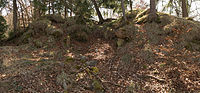
Photo 5: Tower point with the fallen northeast side from the north

Fig. 6: Tower with remains of the wall

Figure 7: Location of the cistern in the outer bailey

Image 8: View into the trench section, behind the area of the outer bailey

Photo 9: View of the main castle from a south-westerly direction, the section ditch can be seen on the left
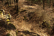
Photo 10: Neck ditch with outer wall from the main castle
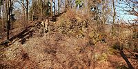
Fig. 11: View of the castle stables from the southeast. In the foreground the neck ditch, behind it the rocks of the main castle


literature
- Andreas Boos : Castles in the south of the Upper Palatinate. The early and high medieval fortifications of the Regensburg area (= Regensburg Studies and Sources on Cultural History , Volume 5). Universitätsverlag Regensburg, Regensburg 1998, pp. 165–169, ISBN 3-930480-03-4 (Dissertation University of Regensburg 1993, under the title: The early and high medieval castles in the south of the Upper Palatinate , 471 pages).
Web links
References and comments
- ^ The presumed aristocratic residence on the side of the Bavarian State Office for Monument Preservation
- ^ The aristocratic seat on the side of the Bavarian State Office for Monument Preservation
- ↑ According to the information board at the Burgstall (see Commons link)
- ↑ The ceramics are privately owned in Regensburg. Dating of the pottery: Andreas Boos
- ↑ In the case of acquisitions of the monastery after 1278, an "Eckard von Löweneck" is a witness or guarantor
- ↑ In a document from 1309 the castle was named castrum nostrum (our castle) by the Bavarian dukes
- ↑ Joseph Kible: Etterzhausen. Past and present. Interest group of the locality Etterzhausen, Etterzhausen 1996, p. 54.
- ^ Source history: Andreas Boos: Castles in the south of the Upper Palatinate - The early and high medieval fortifications of the Regensburg area, p. 165ff
- ↑ Andreas Boos: Castles in the south of the Upper Palatinate - The early and high medieval fortifications of the Regensburg area, p. 167, note 3
- ^ Burgstall Löweneck on the website of the Bavarian State Office for Monument Preservation
- ↑ No further details were known about these subsequent excavations, they probably did not differ very much from the older robbery excavations

Castles: Alteglofsheim Castle | Aufhausen Castle | Barbing Castle | Beratzhausen Castle | Bergstetten Castle | Bernhardswald Castle | Bertholzhofener Schlösschen | Thisbach Castle (exited) | Eggmühl Castle | Etterzhausen Castle | Gebelkofen Castle | Glapfenberg Castle | Hackenberg Castle | Castle House | Hauzendorf Castle | Burgstall Hauzenstein | Hauzenstein Castle | Heitzenhofen Castle | New Hemau Castle | Hirschling Castle | Hochdorf Castle | Hohengebraching Castle | Holzheim am Forst Castle | Inkofen Castle | Karlstein Castle | Köfering Castle | Kollersried Castle | Kürn Castle | Laufenthal Castle | Oberviehhausen Castle | Raitenbuch Castle | Ramspau Castle | Regendorf Castle | Lower Castle (Regenstauf) (exited) | Riekofen Castle | Rohrbach Castle | Rosenhof Palace | Sarching Castle | Schierling Castle | Schönach Palace | Schönberg Palace | Schönhofen Castle | Silbermannsches Schlösschen | Spindlhof Palace | Steinsberg Castle | Sünching Castle | Traidendorf Castle | Triftlfing Castle | Undorf Castle | Wiesent Castle | Wischenhofen Castle | Wörth Castle on the Danube | Wulkersdorf Castle | Zaitzkofen Castle
Castles and ruins: Adlmannstein Castle | Brennberg Castle | Donaustauf castle ruins | Ehrenfels Castle | Forstenberg Castle | Heilsberg castle ruins | Kallmünz castle ruins | Laaber castle ruins | Landeskron Castle (exited) | Castle Loch | Castle ruin Niederviehhausen | Ramspau castle ruins | Castle ruins Schlossberg | Wolfsegg Castle
Tower hill castles (all gone): Tower hill Haidenkofen | Hardt Tower Hill | Kaltenherberg Tower Hill | Langenerling Tower Hill | Schlössl tower hill | Weichslmühle tower castle
Castle stables (expired, unknown castles): Burgstall Auburg (expired) | Burgstall Buchhausen | Burgstall Drackenstein | Burgstall Durchelenburg | Burgstall Egelsburg | Burgstall Eselsburg | Burgstall Haidau | Burgstall Haugenried | Burgstall Hohe Felsen | Karlstein Castle Stables | Burgstall Lichtenberg | Burgstall Lichtenroth | Burgstall Löweneck | Burgstall Luckenpaint (removed) | Burgstall Martinsberg | Burgstall Neuhaus | Burgstall Oberlichtenwald | Burgstall Pentling | Burgstall Regenstauf | Burgstall Rohrbach | Sanding Castle | Burgstall Schlössel | Burgstall Alte Schlossgräben | Burgstall castle slopes | Burgstall Schönhofen | Burgstall Schrotzhofen | Burgstall Schwarzenfels | Burgstall Stadel | Burgstall Stifterfelsen | Burgstall Tiefenthal | Traubling Castle | Burgstall Weihenstefen | Burgstall Zinzendorf