
Dugi Otok
| Dugi Otok | ||
|---|---|---|
 |
||
| Waters | the Adrian Sea | |
| Geographical location | 44 ° 1 ′ N , 15 ° 2 ′ E | |
|
||
| length | 43 km | |
| width | 5 km | |
| surface | 113.3 km² | |
| Highest elevation | Vela Straža 338 m |
|
| Residents | 1655 (2011) 15 inhabitants / km² |
|
| main place | Sali | |
 |
||

Dugi Otok (German Long Island, Italian Isola Lunga) is an island in the archipelago off Zadar in Croatia .
Location and inhabitants
Dugi Otok bears its name due to its geographical shape with a length of about 43 km and a width of only about 4.6 km. At its narrowest point it is only 1 km wide. It extends in a northwest-southeast direction, in line with the islands of Molat in the north and Kornat in the south. In front of her in the east lie the inhabited islands of Zverinac , Iž and Rava . There are also several smaller, uninhabited islands. With 113.3 km² Dugi Otok is the seventh largest Croatian island, with a coastline of 182 km. The highest point on the island, Vela Straža (Great Watch), is 338 m above sea level.
Dugi Otok has 1655 inhabitants (2011) spread over 11 villages. Sali is the parish seat and the largest village. The municipality of Sali also includes the village of Zverinac on the island of the same name opposite Božava. While the west coast consists largely of inaccessible cliffs to the open sea, all inhabited places are on the east side of the island, which faces the mainland. The inhabitants live mainly from fishing, agriculture and tourism. Dugi Otok has no fresh water sources. The houses collect the rainwater in cisterns or the water is obtained from the mainland by weekly water transport by ship.
The connection with the mainland to Zadar is ensured by Jadrolinija with a car ferry to Brbinj and with a catamaran to Božava and Brbinj via Rivanj , Sestrunj and Zverinac. The passenger ferry from Zadar to Sali and Zaglav is operated by G&V Line Iadera . The island was car-free until 1985. An asphalt road that was built in 1980 now connects all the villages between Veli Rat and Sali. The state road is number 109 and is 41.9 km long. With the approaches to the ferry ports Brbinj (state road 124) 1.7 km and to Zaglav (state road 125) 1.1 km, the island has 44.7 km state road. Within the island there is a bus connection to the individual places, which is operated by the Liburnija from Zadar.
The individual villages are:
- Božava - 116 inhabitants
- Brbinj - 76 inhabitants
- Dragove - 36 inhabitants
- Luka - 123 inhabitants
- Sali - 740 inhabitants
- Savar - 53 inhabitants
- Soline - 38 inhabitants
- Veli Rat - 60 inhabitants
- Verunić - 40 inhabitants
- Zaglav - 174 inhabitants
- Žman - 199 inhabitants
history
The island was settled quite early, as evidenced by human finds from prehistoric times. During the excavations in the Vlakno cave in 2011, the remains of a human skeleton were found, the age of which was estimated to be 11,000 years (early Mesolithic). He was called "the oldest Dalmatian Šime" and archaeologists believe that at the time of death he was around 40 years old, between 168 and 172 centimeters tall, and died of a nonviolent death.
Remains of Roman villas and Illyrian castle ruins can be found on the island. Houses and churches from early Croatian times have been preserved. In the 10th century the island was called Pizuh. During this time the residents started fishing. At the beginning of the 11th century it was called Insula Tilagus in written sources, this name is retained in the name of the bay and the Telašćica Nature Park. The current name of the island, written in Glagolitic , dates back to the 15th century.
The remains of the Church of St. John from the 10th and 11th centuries can still be seen as the foundation wall. St. Nicholas Church was built in 1378. The walls are still in ruins.
The first primary school in Dugi Otok was founded in Sali in 1841. The classes were taught in Italian, as in the other primary schools in Dalmatia. Croatian language teaching in Sali was only introduced in 1873. Since 1870 there have been primary schools on Dugi Otok in Božava and Veli Rat. In the years that followed, all of the island's settlements had their own schools. In 1964 there were 515 students. After the wave of emigration after the Second World War, the island's population quickly declined, so that the work of the regional schools had to be stopped in some settlements. Today there is still one school each in Sali and Božava.
The Grpašćak fortress was built during the Austro-Hungarian monarchy in 1911 and was used exclusively as a military post for the Austro-Hungarian navy.
In the second World War Dugi Otok was how the surrounding islands, a retreat of the guerrillas . A monument is dedicated to them in Soline.
On February 13, 1943, the British HMS Thunderbolt sank the Italian minesweeper No. 112 / Mafalda (364 GRT).
tourism
In the southeast of the island is the Telašćica Nature Park . In the Telašćica bay there are some smaller islands and rock islets (Korotan, Galijola, Gozdenjak, Farfarikulac, Gornji Školj and Donji Školj). Immediately to the southeast of it borders the Kornati National Park . There are several caves on the island, the most famous of which is Strašna peć, near Savar. A submarine bunker from the time of the Yugoslav army has been preserved at Dragove. Two more can be found near Božava. An Italian freighter ran aground near Veli Rat in the 1980s, a popular destination for snorkelers and divers. Also in Veli Rat is a 42 m high lighthouse, which is one of the highest in the Adriatic.
Flora and fauna
The Telascica Nature Park serves as a habitat for numerous rare plants. Among the 300 plant species, 8 species of wild and very rare orchids thrive. The animals also feel at home in the nature park. All kinds of animals cavort on the cliffs and in the sea below. The flora and fauna in the water alone include 300 animal and 250 plant species.
The island is partly overgrown with maquis . There are also pine forests, agaves , rock roses and tamarisk trees . The Ragusa knapweed is represented in two subspecies on Dugi Otok.
In Croatia there is a presumably allochthonous occurrence on the island of Dugi Otok off Zadar . The idiot , a kind of slow worm , is found in flat and hilly areas and on dry slopes, especially in areas with loose, herbaceous vegetation. Only here on the island has it spread allochthonously in Croatia . Nine different bat species are native here, some of them are endangered. The house gecko and the Scheltopusik can be found very often. Six different species of snakes, all non-poisonous, are also represented in addition to the countless lizards . Birds make up the largest number of vertebrates on the mainland, with 115 species of birds recorded so far. In addition to many seagulls and falcons, the eagle owl is the largest flying animal. Many migratory birds also fly over Dugi Otok on their way.
Photo gallery

The steep coast of Dugi Otok
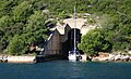
Submarine bunker at Dragove

The Veli Rat lighthouse on the northwestern cape of the island
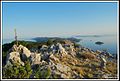
Foresight

Salt lake Mir


Triva
Dugi Otok is also the name of the stage program of the Hessian humor duo Badesalz, which will run from 2007 .
