
Friedrichsthal (Saar)
| coat of arms | Germany map | |
|---|---|---|

|
Coordinates: 49 ° 20 ' N , 7 ° 6' E |
|
| Basic data | ||
| State : | Saarland | |
| County : | Regional association Saarbrücken | |
| Height : | 300 m above sea level NHN | |
| Area : | 9.07 km 2 | |
| Residents: | 9987 (Dec. 31, 2019) | |
| Population density : | 1101 inhabitants per km 2 | |
| Postal code : | 66299 | |
| Area code : | 06897 | |
| License plate : | SB | |
| Community key : | 10 0 41 511 | |
| City structure: | 3 districts | |
City administration address : |
Schmidtbornstrasse 12a 66299 Friedrichsthal |
|
| Website : | ||
| Mayor : | Rolf Schultheis ( SPD ) | |
| Location of the city of Friedrichsthal in the Saarbrücken regional association | ||
  |
||

.jpg)
Friedrichsthal is a Saarland city of the Saarbrücken regional association , about 15 km northeast of Saarbrücken .
geography
location
The city of Friedrichsthal is located in the middle of the Saarkohlenwald on one of the foothills of the Sulzbach valley . The Friedrichsthal district is located in the valley of Moorbach and Stockbach at an average altitude of 240-280 meters. The Bildstock district extends over a ridge of around 360 meters between Hoferkopf, Kallenberg (388 m) and Quierschieder Kopf (361 m). The district of Maybach lies below the Quierschieder Kopf at an altitude of 320 to 340 meters.
The geological composition is shaped by the carbon of the Sulzbach formation and the middle red sandstone of the Hoferkopf.
Districts
The urban area includes the districts of Bildstock, Friedrichsthal and Maybach .
Neighboring communities
In the north the city of Friedrichsthal borders on Landsweiler-Reden ( Schiffweiler ), in the east on Neunkirchen (Saar) and Spiesen-Elversberg , in the south on Altenwald ( Sulzbach / Saar ) and in the west on Quiigart and Merchweiler .
history
On January 1, 1866, the previous mayor's office in Dudweiler was divided into three parts and the independent municipality of Friedrichsthal was formed from the two localities Friedrichsthal and Bildstock. From the 19th century to the middle of the 20th century, the town experienced a great economic boom and grew increasingly large due to the local glass production and then mainly due to the coal mining . In 1969 Friedrichsthal was granted city rights, making it one of the youngest cities in Saarland.
Friedrichsthal

The history of the place began in 1723 with the founding of a glassworks by Count Friedrich Ludwig von Nassau-Ottweiler . Friedrich Ludwig not only had the county of Ottweiler inherited from his father , but also the counties of Nassau-Idstein and Nassau-Saarbrücken by inheritance .
The small town, which was named after its founder Friedrichsthal, consisted in the 18th century essentially of the glassworks located on the Stockbach as well as the houses of the glassmakers and their related professions, such as carters and woodcutters. From the count's side, the smelter operators had been given permission to cut wood for the production of potash . Quartz sand was mined in an open pit at a nearby sandstone dome, the Hoferkopf , which owes its current rugged shape to this mining. In addition, agriculture was operated for personal use. Mainly window glass was manufactured using the so-called moon glass process .
The Friedrichsthal glassmakers were also the first to mine hard coal in the local area to fire the glass melting furnaces. When the Saarbrücken-Neunkirchen railway line was completed in 1852, the Friedrichsthaler trade benefited from the connection to the railway line, and more glassworks were now being built near the new train station. From the second half of the 19th century, the coal mining became an increasingly important economic factor, which helped the community to continue to flourish. While Friedrichsthal and Bildstock together had a population of 421 (360 in Friedrichsthal and 61 in Bildstock), in 1866 there were already around 4,000 inhabitants. In this year Friedrichsthal (including wayside shrine) was set up as an independent municipality, which, however, was initially administered together with Sulzbach by a single mayor in personal union. In 1880 the Friedrichsthal community finally got its own mayor.
The heyday caused by coal mining in the decades around the turn of the century led to a constant expansion of the community's infrastructure: a separate train station was set up early on , Friedrichsthal received its own post office in 1871 , the voluntary fire brigade was founded in 1881, and the Friedrichsthal-Saarbrücken tram line was founded in 1901 established (re-established in the post-war period). Numerous businesses settled in the community and a department store was built on the market square, which gave the industrial town an increasingly (small) urban character. A representative new station building was completed in 1910. This year the population had grown to 13,117. There were also several cinemas in town: the Palast-Theater opened in Saarbrücker Strasse as early as 1919 in a specially constructed building (there were screenings here until the 1980s), followed by the Hoferkopf-Lichtspiele and the Heli-Filmtheater in the Bildstock district. The Evangelical Church was built in 1897 and the Catholic Church of St. Mary in 1927 .
After the First World War , Friedrichsthal came under the temporary administration of the League of Nations as part of the Saar area . As a result of the Versailles Treaty, the mines of the place were subordinated to France until 1935 and continued to be operated in favor of French industry. As a result of the global economic crisis , however, the Helenengrube (the previous main mine in the town) was closed in 1932. In the further course of the 1930s the economic situation stabilized again, the mainspring was still the coal mining. In 1937 a town twinning was signed with Villingen in the Black Forest. After the Second World War , the Saarland came under French administration again for a limited time ( Saar Protectorate , until 1956). Since France was primarily interested in continuing coal mining, the economic situation in Friedrichsthal was somewhat better in the post-war period compared to the other occupation zones in Germany. In the 1960s, however, stagnation gradually set in, when most of the coal reserves were mined. In 1969 the municipality, which consists of the districts Friedrichsthal, Bildstock and Maybach, was granted city rights. With the decline in mining in the 1970s, there was also a gradual economic decline. In the meantime there have been numerous pit damage to the houses, as practically the entire city area is traversed by underground tunnels, some of which were at risk of collapse. As the last mining operation in the urban area, the Maybach mine was finally shut down in 1981.
Wayside shrine


Wayside shrine, the older part of the village located on a hill, goes back to an estate founded by the Counts of Ottweiler around 1700 . A village settlement gradually emerged around this homestead, which was located on what was later named Hofstrasse. The name of the place goes back to a wayside shrine , which today contains a statuette of Mary and the baby Jesus and is located on a sandstone knoll (the Hoferkopf) on the outskirts. According to a legend, the first "wayside shrine" was donated at this point after the end of the Thirty Years' War by a pilgrim who placed a statue of Mary in a hollow tree on the way to Maria Einsiedel . A Celtic sanctuary may have been at this point a long time before . During the Napoleonic period (at the beginning of the 19th century), wayside shrine belonged to the Mairie Neunkirchen , while the neighboring Friedrichsthal belonged to the Mairie Dudweiler . During the Wars of Liberation , the state border between France and the areas administered by Austria and Bavaria ran between the two villages for a short time.
The small village of Bildstock, which had only 61 inhabitants in 1816, grew into a flourishing town in the course of the 19th century thanks to mining. In 1858 the first underground construction shaft was sunk . Several coal mines were built in the local area and resulted in numerous miners and mine officials settling in wayside shrines with their families. Many craft businesses, retailers and inns found their livelihood here. The workers' union movement was also active in the village and, despite massive obstacles by the authorities, was able to inaugurate the legal protection hall , which is the oldest union building in Germany.
As befits the Saarland miners' milieu, the majority of the population in the wayside shrine was Catholic . On November 24, 1907, the parish church of St. Josef was consecrated. The neo-Gothic church building on the market square was designed by the Bonn architect Johann Adam Rüppel . In 1930, wayside shrine was given its own train station (today dismantled to a simple stopping point). In 1931 the Hoferkopf tower was built, which became a symbol of the wayside shrine. The economic prosperity of the place triggered by the coal continued into the time of the Second World War . In 1952/53, a Marienkapelle was built by the population on the Hoferkopf in thanks for the fact that the place had been spared from bombing during the war. As in the rest of the municipality, economic stagnation and finally regression began in the post-war period together with the gradual cessation of mining operations.
In 1994, the almost 21 meter high wooden Hoferkopf tower was built on the Hoferkopf as the successor to the old Hoferkopf tower. However, this had to be demolished in September 2014 due to dilapidation.
Maybach
In 1873 a new coal mine was set up in the western part of the municipality in the Trenkelbachtal, which was run under the name Maybach from 1882 . It was named after the Prussian Minister for Public Works, Albert von Maybach (1822–1904), who paid an official visit to the mine that year. In the immediate vicinity of the pit, a separate miners' settlement was built around 1900, which was called Auf der Maybach and is now the smallest district of Friedrichsthal. The settlement is characterized by the largely uniformly designed semi-detached houses for mine officials, which are lined up along Quierschieder Straße, and the more simply designed semi-detached houses for mine workers. It also had its own school, a church and four dormitories for foreign miners. Few remains of the numerous mine buildings are still preserved today, including the colliery house and the coffee kitchen , which served as a community center between the settlement and the mine area. Overall, Maybach is a relatively completely preserved example of a Saarland mining settlement from the turn of the century and has been a listed building since 1981 .
In October 1930 there was a severe firedamp explosion on the underground floor of the mine , in which 98 miners died (see also: List of accidents in mining ). The Maybach mine expanded considerably in the period between the world wars and was extensively restructured when the Helenen mine in Friedrichsthal and the nearby Altenwald mine ( Sulzbach ) ceased production in 1932 . The not yet exhausted coal reserves in the area have now been mined from Maybach. Even after the Second World War, hard coal was still mined in the mine, until production operations ceased in 1964 and the Maybach mine was finally shut down in 1981.
Population development
.svg)
|
|
politics

City council
Since the local elections on May 26, 2019 , the Friedrichsthal City Council has had 33 members. They are distributed among the individual groups as follows:
| Political party | SPD | CDU | left | AfD | Green | FDP | total |
|---|---|---|---|---|---|---|---|
| Seats | 10 | 9 | 4th | 4th | 4th | 2 | 33 |
| G / V | - 4th | - 3 | ± 0 | + 4 | + 3 | + 1 |
P / L = profit or loss compared to the previous 2014 local election
mayor
- 1865–1879: Franz Nikolaus Ganns
- 1890–1915: Jakob Philipp Forster
- 1915–1920: Ernst Hermann Ballke
- 1921–1933: Paul Kondruhn
- 1934–1945: Wilhelm Braun
- 1945–1946: Richard Rauch, SPD
- 1946–1955: Ludwig Schnur , CSU / CVP , CDU
- 1956–1962: Friedrich Wilhelm Philipp Edelmann
- 1966–1990: Wolfgang Grausam, CDU
- 1990–2008: Werner Cornelius, SPD
- since 2008: Rolf Schultheis, SPD
coat of arms
On June 23, 1936, the Friedrichsthal community received the right to use its own coat of arms . The two-part coat of arms shows a golden crowned lion in the upper, blue field, holding a miner's lamp in his right paw. The lower, golden field shows two crossed glassmaker pipes . The golden lion on a blue field ( Nassau lion) refers to the historical affiliation of the community to the territory of the Counts of Nassau-Saarbrücken . The miner's lamp stands symbolically for mining and the glassmaker's pipes for the glass industry, thus for the two economic sectors to which the community owes its boom in the 19th and 20th centuries.
The coat of arms was adopted by the city of Friedrichsthal in 1969 when it was granted city rights.
In addition, the district of Bildstock has its own coat of arms, which, however, was never officially awarded. It is square in green and silver (that is, divided into 4 fields) and shows the name-giving wayside shrine , the rose of Ottweiler , a wolf tang as well as mallets and irons as symbols for mining.
Town twinning
Economy and Infrastructure

traffic
Private transport
Friedrichsthal is connected to the national trunk road network via the federal highways 8 ( Perl - Bad Reichenhall ) and 623 (to Saarbrücken ) .
Public transport
Friedrichsthal forms the comb 101 in the Saarland transport association ; Both the bus and the regional train can be used with one ticket. More breakpoints on section Türkismühle-Saarbrücken of the Nahe Valley Railway tie the place where on the railway network. The Friedrichsthal (Saar) train station is located on the southwestern outskirts and was inaugurated in 1852. In 1930 another train station was built in Bildstock ( 49 ° 20 ′ 13.4 ″ N , 7 ° 5 ′ 39.3 ″ E ) , but the station building has since been demolished and the train station has been reduced to a stop . In 2004, the barrier-free Friedrichsthal Mitte stop ( 49 ° 19 ′ 37.5 ″ N , 7 ° 5 ′ 38.2 ″ E ) was opened, which is closer to the town center. All these stops are served by the regional train line RB73 on the Saarbrücken - St. Wendel - Neubrücke (Nahe) route every half hour. Regional express trains run through here; the next RE stop is Neunkirchen .
Local businesses
The Becker Mining Systems AG is a company based in Friedrichsthal mining supplier with 1,800 employees (as of 2011) and an annual turnover of 255 million euros (as of 2011).
telecommunications
The highest free-standing transmission tower in Saarland, a 103 meter high telecommunications tower belonging to Deutsche Telekom AG, is located in the Bildstock district.
nature and environment
- Landscape of industrial culture north (LIK.Nord)
Friedrichsthal is part of the major nature conservation project Landscape of Industrial Culture North (LIK.Nord). The cities of Neunkirchen and Friedrichsthal, the municipalities of Illingen, Merchweiler, Schiffweiler and Quiigart as well as the district of Neunkirchen and Industriekultur Saar GmbH (IKS) have merged to form a special purpose association and in 2009 won the federal competition "Large-scale nature conservation projects and rural development" from the Federal Environment Ministry. The aim of the project is to shape the future-proof development of the old industrial landscape, which is characterized by mining. This is intended to maintain and further expand the biodiversity of the landscape through maintenance and targeted interventions. The landscape laboratory “ Post-Mining Landscape” is located in the area of the city of Friedrichsthal . The project has been in the implementation phase since the end of 2013.
Culture
In 1972 the amateur choir Chorwurm was founded in Bildstock .
religion
There are the following churches in Friedrichsthal:

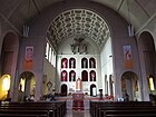
Wayside shrine, St. Josef, interior
Friedrichsthal, St. Marien, Inneres

Friedrichsthal, Evangelical Church, Interior


.JPG)
.JPG)
Sons and daughters
- Otto Weil (born June 26, 1884; † February 20, 1929 in Saarbrücken), painter
- Aloys Herrmann (born November 27, 1898 in Bildstock; † October 16, 1953 in Baden-Baden), university professor in Saarbrücken
- Heinz Helfgen (born March 7, 1910; † 1990), travel writer
- Johannes Driessler (born January 26, 1921 in Friedrichsthal, Saar; † May 3, 1998 in Detmold), composer
- Helmut Hofmann (born November 14, 1925 in wayside shrine; † August 21, 2017), boxer
- Norbert Dietrich (born January 24, 1931 in wayside shrine; † July 5, 2003 in Sulzbach / Saar), gymnast
- Rolf Lauer (born September 11, 1931 in Bildstock, † May 25, 1986 in Völklingen), gymnast
- Horst Linn (born June 14, 1936), sculptor
- Manfred Römbell (born December 3, 1941 - † June 21, 2010 in Saarbrücken), writer
- Sigurd Rompza (* 1945), painter
- Karl-Heinz Klär (born January 16, 1947), politician (SPD)
- Horst Oskar Siffrin (born October 5, 1947), diplomat
- DJ Karotte (Peter Cornely) (born February 15, 1969), disc jockey & music producer
- Alexander Kopainski (* 1996 in wayside shrine), graphic artist
literature
In the Rotstrasse trilogy, the author Manfred Römbell processed his childhood and youth in the post-war period in wayside shrines . The "Rotstrasse" refers to the Brotstrasse on the northeastern outskirts of Bildstock.
- Manfred Römbell: Rotstrasse Time (1989); Rotstrasse Dreams (1993); End of Rotstrasse (1996)
Web links
- Official website of the city of Friedrichsthal
- Literature about Friedrichsthal in the Saarland Bibliography
- Link catalog on Friedrichsthal / Saar at curlie.org (formerly DMOZ )
Individual evidence
- ↑ Saarland.de - Official population figures as of December 31, 2019 (PDF; 20 kB) ( help ).
- ↑ http://www.saarlandbilder.net/orte/friedrichsthal/glashuette.htm
- ↑ http://www.friedrichsthal.de/index.php?id=301
- ↑ http://www.friedrichsthal.de/index.php?id=300
- ↑ Maybach mine (Saarlandbilder.net)
- ^ Chronicle of the parish of St. Josef Bildstock. Edited by the Catholic parish office, wayside shrine. Ottweiler 1957, p. 28.
- ↑ http://www.stadtverband-saarbruecken.de/magazin/artikel.php?artikel=492 ( page no longer available , search in web archives ) Info: The link was automatically marked as defective. Please check the link according to the instructions and then remove this notice.
- ^ Chronicle of the parish of St. Josef Bildstock. Edited by the Catholic parish office, wayside shrine. Ottweiler 1957, p. 29.
- ^ Chronicle of the parish of St. Josef Bildstock. Edited by the Catholic parish office, wayside shrine. Ottweiler 1957, p. 40.
- ↑ The tower on the website of the Förderverein Hoferkopfturm eV
- ↑ Saarland: LIK.Nord | Saarland.de. Retrieved July 24, 2017 .