Faizabad (district)
| Faizabad District फ़ैज़ाबाद जिला |
|
|---|---|

|
|
| State | Uttar Pradesh |
| Division : | Faizabad |
| Administrative headquarters : | Faizabad |
| Area : | 2341 km² |
| Residents : | 2,470,996 (2011) |
| Population density : | 1,056 inhabitants / km² |
| Website : | faizabad.nic.in |
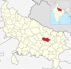
The Faizabad district ( Hindi : फ़ैज़ाबाद जिला ) is a district of the Indian state of Uttar Pradesh . The administrative center is the eponymous city of Faizabad .
geography
Faizabad District is located in the Awadh (Oudh) region in central Uttar Pradesh and is part of the Faizabad Division . Neighboring districts are Gonda in the north, Basti in the northeast, Ambedkar Nagar in the east, Sultanpur in the southeast, Amethi in the southwest and Barabanki in the west.
The area of the district is 2341 km². The district area belongs to the Ganges plain . The terrain is completely flat and is used intensively for agriculture. In the north, the Ghaghara , a large tributary of the Ganges , forms the border of the district. In the southwest, the Gomti river briefly touches the district area. In addition, the two source rivers of the Tamsa , Marha and Biswi, arise in the Faizabad district.
Administrative division
The Faizabad District is divided into the five Tehsils Faizabad, Bikapur, Sohawal, Milkipur and Rudauli.
history

The area of today's Faizabad District is the core of the Awadh region. The city of Ayodhya , located in the immediate vicinity of the district capital Faizabad, was the capital of the kingdom of Kosala in ancient times and, according to Hindu mythology, is the birthplace of the god Rama . In the 14th century the area came under Islamic rule. At the time of the Mughal Empire , the region formed the province ( suba ) Awadh (Oudh). In 1724 the Nawab (governor) Sa'adat Khan made himself independent and founded the dynasty of the Nawabs of Oudh . The capital was initially Faizabad, then from 1775 Lucknow . In 1856 Oudh was annexed by the British .
Faizabad District was established during the British rule. The district belonged to the province of Oudh, which in 1902 was merged with the Northwestern Provinces to form the United Provinces of Agra and Oudh . After Indian independence in 1947, the United Provinces became the state of Uttar Pradesh . In 1995, the Ambedkar Nagar District was formed from the eastern part of Faizabad District .
population
According to the 2011 census, the Faizabad district has 2,470,996 inhabitants. Between 2001 and 2011, the population grew by 18 percent and thus somewhat more slowly than the Uttar Pradesh mean (20 percent). The population density of 1056 inhabitants per km² is still higher than the already high average for the state (829 inhabitants per km²). The district is quite rural: only 14 percent of the population lives in cities. The degree of urbanization is thus lower than the mean value for Uttar Pradesh (22 percent). At 69 percent, the literacy rate is in line with the state average (68 percent).
According to the 2001 census, Hindus make up the majority of the residents of the district with 85 percent. There is also a Muslim minority of 15 percent.
Cities
| city | Population (2001) |
|---|---|
| Ayodhya | 49,593 |
| Bhadarsa | 11,369 |
| Bikapur | 12,355 |
| Faizabad | 144.924 |
| Gosainganj | 12,622 |
| Rudauli | 36,804 |
literature
- Imperial Gazetteer of India. Volume 12: Einme to Gwalior. New edition, Clarendon Press, Oxford 1908, pp. 109–117 , keyword: Fyzābād District .
Web links
Individual evidence
- ↑ Census of India 2011: Primary Census Abstract - Uttar Pradesh (PDF; 1.7 MB).
- ^ Census of India 2001: Basic Data Sheet. District Faizabad (47), Uttar Pradesh (09). (PDF; 55 kB)
- ↑ Census of India 2001: Population, population in the age group 0-6 and literates by sex - Cities / Towns (in alphabetic order) ( Memento from June 16, 2004 in the Internet Archive )

