
Wetlands and water regions in Namibia

This article, Wetlands and Water Regions in Namibia, deals with the wetland types defined on the basis of the Ramsar Convention in the south-west African state of Namibia and the various water regions.
Wetlands
Article 1 of the Ramsar Convention says: "1. Wetlands within the meaning of this Convention are wet meadows, bog and swamp areas or bodies of water that are natural or artificial, permanent or temporary, standing or flowing, fresh, brackish or salt water, including such Marine areas that do not exceed a depth of six meters at low tide. "
Due to the semi-arid to arid climate in Namibia one speaks basically only of wetlands ("wet areas"). About 5% of the land area of Namibia is covered by these areas. In a broader sense, it can also be rivers , lakes and reservoirs .
In Namibia these are among others:
Selection of wetlands
| Surname | region | category |
|---|---|---|
| Cuvelai | Oshana | Wetland ( oshana ) |
| Etosha pan | various | Wetland |
| Gross Barmen | Otjozondjupa | source |
| Kunene estuary | Kunene | Estuary |
| Linyanti Marshland | Zambezi | Marsh / swamp |
| Orange mouth | ǁKaras | Estuary |
| Sandwich Harbor | Erongo | Wetland |
| Sesfontein | Kunene | source |
| Walvis Bay | Erongo | Wetland |
Source: Ramsar Sites Information Service; nnf.org.na
Water regions

Namibia can be subdivided into eight different water regions , most of which have only temporarily water-bearing ( ephemeral ) rivers - called riviers in Namibia - and which differ characteristically in terms of their hydrology .
Kalahari fish river
This region includes a number of dry rivers (Rivieren), including the Auob - Nossob - Olifants system, the Molopo and the Fish River (Fish River), who is actually in the Oranje drained. Hardap and Naute dams are important water reservoirs in this water region. Almost all rivers have their origin in the high- rainfall Khomas highlands south and Neudammer highlands east of Windhoek . But only the fish river regularly carries larger amounts of water and descends as far as the Orange River. Auob, Olifants and Nossob rarely reach the Molopo , the course of which is now blocked by larger sand dunes. Settlements and agriculture in this region are supplied exclusively by groundwater. There is an artesian basin at Stampriet . There are also numerous vleis and pans throughout the region , which fill up when there is heavy rainfall and contribute to the water supply for livestock and game. The Ai-Ais thermal spring, which is around 60 ° C, is located in the rocky valley .
The Kalahari Fish River Water Region includes the following rivers, among others:
- Fish river
- Lion river
- Konkiep , again in the Fish River empties
- Auob
- Olifants River
- Nossob .

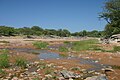
Fish River at Gibeon

Auob at Welverdiend / Mata Mata


Kunene
The Kunene water region is determined by the year-round water-bearing Kunene and extends from Ruacana west to Epupa and south to Opuwo and to the Khumib . Only directly in the Kunenetal does the river allow year-round agriculture, such as the cultivation of millet or maize. In the river areas far mainly found transhumance instead, the water supply is limited in practice to the local groundwater resources.

Kunene at Swartbooisdrift

Kunene at the Epupa Falls
Ondoto Rivier north of Epembe


Namib
The Namib water region extends from the Kunene in the north about 100 km inland and then stretches along the entire coast to the south to the Oranje near Oranjemund . The region occupies its widest point in the area of the edge step gap , where it extends from the coast inland to Otavi . The Namib water region comprises 12 large ephemeral rivers ( Riviere ), which only come off sporadically and in the hinterland when there is heavy rainfall. More frequent floods only occur in rivers whose catchment area extends into the moist highlands. In the southern Namib water region, the rivers Koichab , Tsauchab and Tsondab do not extend to the Atlantic, but rather seep into an end vlei in the Namib sand lake . In the central and northern Namib water region, where the Namib is largely a rocky desert, the rivers also reach the coast when the tide is stronger. In addition to their ephemeral character, a characteristic of all rivers in this water region is the decrease in the amount of water from the upper to the lower reaches, due to evaporation and infiltration in the subsurface. Almost all rivers, however, have significant, near-surface aquifers in the lower reaches and estuary . Year-round groundwater outflows and springs lead to larger wetlands there with sometimes dense gallery vegetation .
The Namib water region includes the following rivers:
- Khumib
- Hoarusib
- Hoanib
- Uniab
- Koigab
- Huab
- Ugab
- Omaruru
- Swakop and tributary Khan
- Kuiseb
- Tsondab , ends in Tsondabvlei before reaching the Atlantic
- Tsauchab , ends in Sossusvlei before reaching the Atlantic
- Koichab , ends before reaching the Atlantic in the Namib

Ugab at Ugab Crossing

Flood plain in the Hoanib valley, west of Sesfontein

Tsauchab at Sossusvlei

Tsauchab on the D854 east of Sesriem


Northern Kalahari

This water region in the regions Kavango East and Kavango West in northeastern Namibia is determined by the East-West direction extending in the, specified orange sand dunes of the Kalahari and therein extending, flat, escalating fossil Riviere , so-called Omiramba embossed.
While a few Omiramba, including the Omatako , run north to the Okavango , the remaining Omiramba like the Khaudum drain south-west towards the Okavango Delta, but seep into the central Kalahari without reaching it .
Even in very rainy years, the Omiramba rarely have water in their entire length. However, these rivers play an important ecological role for flora and fauna . The Omiramba are filled with boggy ground. Precipitation is absorbed by this underground and is also stored there over the dry season. Therefore, Omiramba usually still have a groundwater flow that supports appropriate vegetation in the actual river valley, so that pronounced gallery forests can be found and the valley floors are covered with reeds , grasses and water lilies. The Omiramba connected to the Okavango are also regularly flooded in the lower reaches by the floods of the Okavango. With their vegetation, the Omiramba form the natural migration routes of game in the dry season.
The following larger omiramba can be found in the Kavango region:
Orange
The Oranje water region of Namibia is determined by the southern border river Oranje (Gariep) and extends from the ǀAi-ǀAis Richtersveld Transfrontier Park parallel to the catchment area of the Gamchab to the northeast and then east to the Molopo . However, the contribution of this region to the water of the Orange River is only around 1.5%; the majority of the water comes from the upper reaches of the Orange River in South Africa .
Oshana

The Oshana system is a wetland between the Kunene River and the Etosha Pan , which flows in a large number of fan-like flat valleys, the Oshanas , in a north-south direction. Many of these runs only carry water during the irregular flood events.
Okavango
The Okavango water region is determined by the Okavango and its wide valley. It stretches from Mpungu in the west to Bagani and the Popa Falls, where the Okavango bends south and the “pan handle” of the Okavango delta begins. The year-round water flow of the Okavango, which has its highest level in Namibia between January and April, and an aquifer fed by the Okavango and stretching about 30 km on both sides of the river , also allow large-scale intensive agriculture with irrigated agriculture and ensure the water supply for the population. At Ndiyona it forms together with the Cuito a large wetland, the Okavango-Cuito marshland.


Zambezi

The Zambezi water region includes the eastern Caprivi Strip and parts of the Kwando in the west, Linyanti and Chobe with Lake Liambezi in the south and the Zambezi in the east. It comes from the uplift of the Mambova fault and is a remnant of the Makgadikgadi Paleo Lake.
With an annual rainfall of over 700 mm and a regular rainy season, the Zambezi water region is the wettest region in Namibia. It offers a mosaic of grassland, savanna forests and open water holes and swamps.
The year-round wetlands and rivers as well as the heavy rainfall also lead to an increased incidence of diseases such as schistosomiasis and malaria . Since around 70% of the population use the untreated surface water as drinking water, typhus , cholera and dysentery are also widespread.
See also
- List of rivers in Namibia
- List of lakes in Namibia
- List of dams in Namibia
- List of Ramsar areas in Namibia
Web links
Individual evidence
- ^ Mary Seely, John Pallett: Namib - Secrets of a desert uncovered. Venture Publications, Windhoek 2008, ISBN 978-3-941602-06-9 , p. 44.
- ↑ Welcome to the Ramsar Sites Information Service ( English ) Ramsar. Archived from the original on January 20, 2012. Retrieved on April 7, 2019.
- ↑ Wetlands of Namibia ( English , PPT) nnf.org.na. Archived from the original on November 15, 2011. Retrieved on April 7, 2019.