
Geography of Sierra Leone

Sierra Leone is located in West Africa , on the west coast of the African continent, north of the equator between the 7th and 10th parallel . The republic borders on Guinea to the north and northeast , Liberia to the south and southwest, and the Atlantic Ocean to the west .
physical geography
geology

Sierra Leone can be divided into three geological areas. From east to west, these are the West Africa craton , the Rokelide as an orogenic belt and an approximately 20 to 30 kilometer coastal strip of sediments .
Geomorphological classification
Sierra Leone covers an area of 71,740 square kilometers , of which only 120 km² are water surfaces . The country is dominated by four geomorphological regions:
- Mangroves
- Guinean high forests
- plateau
- Mountain regions in the east, especially the Loma Mountains including the Bintumani at 1945 m
Climatic geography


According to Köppen-Geiger , Sierra Leone can be divided climatically into a tropical monsoon region , which takes up around 90 percent of the country's area, and a tropical savanna zone , which is only found in the northeast.
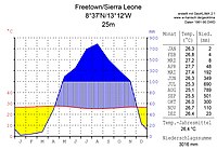
Rainfall in the country is up to 5000 millimeters per year on the coastal regions and no less than 2000 mm in the east. This makes the Sierra Leonean coast one of the wettest regions in West Africa.
The year is divided into a rainy and a dry season . Since Sierra Leone is north of the equator, the rainy season of the West African monsoons begins in mid-May and is characterized by daily thunderstorms and rainfall. In the months of August and September it can also rain continuously. The dry season begins in mid-October and rainfall becomes less frequent. In December and January, the climate is characterized by the Harmattan , a wind from the Sahara that brings dust and cool air with it. February, March and April are the hottest months with rare rainfall. Because of the harmattan, the locals also speak of three seasons: rainy season (rainy season), harmattan season (windy time) and dry season (dry season).
The temperatures are only characterized by slight daily and seasonal fluctuations. The temperature in Freetown is 28 to 32 degrees Celsius almost all year round, day and night .
Freetown

Waters

The main inland waters, i.e. rivers and lakes of Sierra Leone, are:
- Rivers (from north to south)
- Great Scarcies (Kolenté), (129 km in Sierra Leone)
- Little Scarcies (Kava; Kaba) (161 km)
- Rokel (Seli) (290 km)
- Taia (Jong; Taye)
- Sewa (209 km)
- Moa (266 km)
- Mano (105 km)
- Lakes
- Mape Lake with an area of up to 85 km²
- Mabesi lake with up to 36 km²
- Sonfon Lake , an important nature reserve
- Coastal waters
- Sierra Leone River , estuary near the capital Freetown
- Sherbro , estuary or strait
Islands
Large inland islands are Tasso and Bunce , in the Atlantic mainly Sherbro and Dublin .
Mountains

The highest peaks in Sierra Leone are in the Western Area around the capital Freetown with the 888 m high Picket Hill in the Lion Mountains and in the east of the country with the Bintumani , the highest mountain in West Africa with 1945 m in the Loma Mountains .
Bintumani

Soil geography
Flora and fauna
flora
Sierra Leone has a rich flora due to the different habitats in the tropics . Elephant grass is one of the most important plants in the savannah areas of the north and northeast . On the coasts, the red mangrove , which reaches a height of up to 30 meters, is widespread. Among other things, the oil palm and mango trees are common across the country. The Bulbophyllum parvum is endemic .
fauna
_Cephalophus_jentinki.png)
Sierra Leone was once home to many species typical of the tropical rainforest . Due to the civil war in the 1990s and its use as bushmeat , numerous species were exterminated or severely decimated.
The best-known animal species include the elephant , hippopotamus , red buffalo and manatee . In addition, Sierra Leone is one of the last refuge areas for the pygmy hippopotamus , the African gray parrot and the Jentink duiker . Extinct include the West African lion , the Kob and the white rhinoceros as well as the West African hartebeest , roan antelope , sitatunga and giant eland . With up to 20 antelope species , Sierra Leone has a very large biodiversity in relation to the size of the country.
Nature and environmental protection

Due to the strong population increase, especially since the 1950s, nature came under increasing pressure. In addition to slash- and- burn agriculture and hacking , overfishing and illegal deforestation are also a threat. Large parts of the primary forest have therefore been destroyed. Since the civil war, more emphasis has been placed on nature conservation and environmental protection through political pressure. Among other things, numerous new nature reserves have been designated in the country .
Sierra Leone has signed various international agreements on nature and environmental protection:
- Biodiversity Convention
- United Nations Framework Convention on Climate Change
- United Nations Convention to Combat Desertification
- Washington Convention on the Protection of Species
- Convention on the Law of the Sea
- Convention on Fishing and Conservation of the Living Resources of the High Seas
- Nuclear Test Ban Treaty
- Ramsar Convention
- Kyoto protocol
Human geography
Political geography
Political structure

Sierra Leone is politically divided into four provinces and one area. These are in turn divided into a total of 16 districts. The provinces are also still in chiefdoms . There is also a subdivision into constituencies and wards .
| province | Capital | Area (2004) |
Population (2015) |
Districts | Chiefdoms |
|---|---|---|---|---|---|
| Eastern | Kenema | 15,553 km² | 1,641,012 | 3 | 45 |
| Northern | Makeni | 4th | 55 | ||
| North West | Port Loko | 1,162,065 (2017) |
3 | 34 | |
| Southern | Bo | 19,694 km² | 1,438,572 | 4th | 52 |
|
Western (area) |
|
557 km² | 1,493,252 | 2 | - |
National territory
The country is located in West Africa on the West African Atlantic coast between latitudes 7 ° –10 ° north latitude and longitudes 10 ° –13 ° west longitude. The northernmost point is 10 ° north latitude on the border with Guinea. It stretches for around 75 kilometers. The easternmost point is not far south of the country triangle with Guinea and Liberia at about 10 ° 16'18.00 "west longitude. The southernmost point is at 6 ° 55'24.37" north latitude at Mano on the border with Liberia. To the west, Sierra Leone extends to 13 ° 17'54.49 "west longitude in the state capital Freetown.
Sierra Leone borders on neighboring countries for a total of 1093 kilometers. The border with Guinea is 794 km long and that with Liberia 299 km. The Atlantic coast is 402 kilometers long.
Settlement geography
Around 22 percent of the state's area is used for agriculture (as of 2015), and almost 38 percent (27,258.21 km²) is forested (as of 2010).
The largest urban settlements in the country are (as of 2015): Freetown (1,055,964 inhabitants), Waterloo (208,795), Kenema (200,443), Bo (174,369), Port Loko (160,217), Koidu (128,303) and Makeni (125,907) .
Population geography

7,076 million live in Sierra Leone (as of 2015). Population growth is around 2.4 percent per year (as of 2018). The total population has almost tripled from 1960 to the present day and has doubled since 1985. The population density per square kilometer is almost 100, with up to almost 2700 people per km² in the Western Area .
The fertility rate is 4.7 children per woman. Accordingly, almost 42 percent of the population is younger than 15 years and just 3.8 percent older than 65 years (as of 2018). Life expectancy was 59 years in 2018, ranking 212th out of 223 countries and areas examined worldwide. The average age of the Sierra Leoneans is 19.1 years.
See also
Web links
Individual evidence
- ^ A b Suzanne LeVert: Cultures of the World: Sierra Leone . 2007, ISBN 978-0-7614-2334-8 , pp. 7 .
- ^ Thomas Schlueter, Martin H. Trauth: Geological atlas of Africa: with notes on stratigraphy, tectonics, economic geology, geohazards, geosites and geoscientific education of each country , Springer, 2008, ISBN 978-3-540-76324-6 , p 220.
- ↑ a b CIA: The World Factbook: Sierra Leone .
- ^ Robert E. Gabler: Physical Geography . Cengage learning. 2008.
- ^ RH Hughes, JS Hughes: A directory of African wetlands , IUCN, 1992, ISBN 978-2-88032-949-5 , p. 435.
- ↑ Linda Blinker: COUNTRY ENVIRONMENT PROFILE (CEP) SIERRA LEONE . CONSORTIUM PARSONS BRINCKERHOFF. September 2006. Archived from the original on October 1, 2008. Retrieved July 8, 2019.
- ^ Panthera leo (West Africa subpopulation). The IUCN List of Threatend Species, March 7, 2014. Retrieved May 18, 2017.
- ↑ Kobus kob. The IUCN List of Threatend Species, January 7, 2016. Retrieved May 18, 2017.
- ↑ Black Rhino. International Rhino Foundation. Retrieved May 19, 2017.
- ^ African Antelope Database 1998. IUCN / CCS Antelope Specialist Group, 1998, p. 47 ff.
- ^ Antelopes: Global Survey and Regional Action Plans, Part 3. West and Central Africa. IUCN / Antelope Specialist Group, 1990, p. 41.
- ^ A b c People and Society - Sierra Leone. CIA World Fact book. Retrieved October 17, 2019.
- ^ Sierra Leone Census . Geo Hive, 2004 ( Memento from December 12, 2013 in the Internet Archive )
- ↑ PRESIDENT KOROMA LAUNCHES 2015 POPULATION AND HOUSING CENSUS PROVISIONAL RESULTS. Sierra Leone State House, March 31, 2016. ( Memento of April 5, 2016 in the Internet Archive )
- ↑ Constituencies Description BD2017 ( Memento of November 14, 2017 in the Internet Archive ). National Electoral Commission, 2017, accessed November 14, 2017.
- ↑ Sierra Leone: arable land (% of land area). Factfish, 2015.
- ↑ GLOBAL FOREST RESOURCES ASSESSMENT 2010 COUNTRY REPORT SIERRA LEONE. Forestry Department, Food and Agriculture Organization of the United Nations, 2010, p. 10.
- ^ World Population Prospects . Population Division, United Nations, accessed July 29, 2017.
54 African member states of the United Nations :
Egypt |
Algeria |
Angola |
Equatorial Guinea |
Ethiopia |
Benin |
Botswana |
Burkina Faso |
Burundi |
Djibouti |
Ivory Coast |
Eritrea |
Gabon |
Gambia |
Ghana |
Guinea |
Guinea-Bissau |
Cameroon |
Cape Verde |
Kenya |
Comoros |
Democratic Republic of the Congo |
Republic of the Congo |
Lesotho |
Liberia |
Libya |
Madagascar |
Malawi |
Mali |
Morocco |
Mauritania |
Mauritius |
Mozambique |
Namibia |
Niger |
Nigeria |
Rwanda |
Zambia |
São Tomé and Príncipe |
Senegal |
Seychelles |
Sierra Leone |
Zimbabwe |
Somalia |
South Africa |
Sudan |
South Sudan |
Swaziland |
Tanzania |
Togo |
Chad |
Tunisia |
Uganda |
Central African Republic
Other areas:
Ceuta and Melilla |
Canary Islands |
Mayotte |
Reunion
Disputed areas:
Puntland |
Somaliland |
Western Sahara
Geography of the States of:
Asia |
Europe |
North America |
Oceania |
South America