
Tri-border region
A triangle - also known as a country triangle - is the geographical point at which three equal borders and thus three equally administered territories ( states , member states , administrative units, etc.) meet. Such tri-border areas are mostly known when they have existed for a long time or when three cultures meet. Usually this point is marked by the respective national flag or monument . While three countries often meet, four- or multi-country corners are very rare.
General overview
Of the currently (2015) 195 states on earth recognized by the United Nations , 135 have at least one such boundary point. There are a total of 159 three-country corners on earth. The frequency of occurrence of three-country corners depends on the number of neighbors , but also on the number of sea borders . So have island nations like Japan or also states like Portugal , Denmark and San Marino , which only have one neighboring country - z. B. because they are completely surrounded by a state - none. Two neighboring countries are also not a sufficient criterion, as z. B. with respect to the USA in North America . The area of a country also has only a limited relationship to its number of triangles: The country with the most is the People's Republic of China with 16, while Russia , the largest country in the world in terms of area, has only 10.
Austria has nine three-country corners at its borders (making it the country with the most three-country corners in Europe), Germany seven, Switzerland six, and Liechtenstein has two three-country corners.

The border triangle CH-DE-FR at the Rhine port of Basel
Vaalserberg : border triangle BE-DE-NL

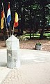
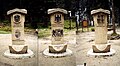
Sevenig : European monument near the border triangle BE-DE-LU
AT-CZ-DE tri-border region

Zittau : border triangle CZ-DE-PL

AT-HU-SK tri-border area

Treriksröset : triangle FI-NO-SE

Berg Ofen : border stone triangle AT-IT-SI

Monte Roraima : border triangle BR - GY - VE
.jpg)


Three-country corner worldwide
The following listings show lists of all international three-country corners. The countries are arranged alphabetically in ascending order.
Australia is the only state on the continent of the same name and therefore does not have a tri-border region.
The sectors of the continent of Antarctica converge at the geographic South Pole .
Africa
In Africa there are 63 three-country corners, four of which are also considered to be four-country corners :

America
In Central America there are 2 triangles, in South America 13:
| Country 1 | Country 2 | Country 3 | Remarks |
|---|---|---|---|
| Argentina | Bolivia | Chile | Cerro Zapaleri , 5653 m, 22 ° 48'56 "S 67 ° 10'43" W. |
| Argentina | Bolivia | Paraguay | |
| Argentina | Brazil | Paraguay | Hito Tres Fronteras , known for the Iguaçu waterfalls |
| Argentina | Brazil | Uruguay | Bella Unión / Isla Brasilera |
| Belize | Guatemala | Mexico | (Central America) |
| Bolivia | Brazil | Paraguay | |
| Bolivia | Brazil | Peru | |
| Bolivia | Chile | Peru | |
| Brazil | France (French Guiana) | Suriname | |
| Brazil | Guyana | Suriname | |
| Brazil | Guyana | Venezuela | on Mount Roraima |
| Brazil | Colombia | Peru | Tres Fronteras , in the Amazon rainforest with a tri-city Tabatinga , Leticia , Santa Rosa with more than 100,000 inhabitants |
| Brazil | Colombia | Venezuela | |
| Ecuador | Colombia | Peru | |
| Guatemala | Honduras | El Salvador | (Central America) |
Since all states on the North American mainland stretch from the Pacific to the Atlantic Ocean , there is no triangle there.
The states of the United States make up 38 Tri-State Areas .
Asia
There are 42 triangles in Asia :
| Country 1 | Country 2 | Country 3 | Remarks |
|---|---|---|---|
| Abkhazia | Georgia | Russia | Starting from the Manytn lowlands as the southern border of Europe , this point is in Asia. If the main ridge of the Caucasus is taken as the border of Europe , the point would be on the border between Europe and Asia. |
| Afghanistan | Iran | Pakistan |
29 ° 52 ' N , 60 ° 52' O cow-e Malek Siah(peak)
|
| Afghanistan | Iran | Turkmenistan | until December 1991 triangle between Afghanistan, Iran and the Soviet Union |
| Afghanistan | Pakistan | People's Republic of China | Border point since 1895. The adjacent area of Pakistan was part of British India until 1947 and is claimed by India. The neighboring area of China belonged to the Republic of East Turkestan from 1944 to 1949. |
| Afghanistan | Tajikistan | People's Republic of China | until December 1991 triangle between Afghanistan, China and the Soviet Union |
| Afghanistan | Uzbekistan | Tajikistan | |
| Afghanistan | Uzbekistan | Turkmenistan | |
| Egypt | Gaza Strip | Israel | |
| Armenia | Azerbaijan | Georgia | |
| Armenia | Azerbaijan ( Nakhchivan ) | Iran | |
| Armenia | Azerbaijan ( Nakhchivan ) | Turkey | |
| Armenia | Nagorno-Karabakh (de facto) or Azerbaijan (de jure) | Iran | |
| Armenia | Georgia | Turkey | |
| Azerbaijan | Georgia | Russia | Starting from the Manytn lowlands as the southern border of Europe , this point is in Asia. If the main ridge of the Caucasus is taken as the border of Europe , the point would be on the border between Europe and Asia. |
| Azerbaijan | Nagorno-Karabakh | Iran | |
| Azerbaijan ( Nakhchivan ) | Iran | Turkey | until 1991 tri-border area between the Soviet Union , Iran and Turkey |
| Bangladesh | Myanmar | India | 1947–1971 border triangle between Burma, India and Pakistan ( East Pakistan ) |
| Bhutan | India | People's Republic of China | (Osteck); 1912–1950 tri-border area between Bhutan, Tibet and Sikkim, 1950–1975 between Bhutan, the People's Republic of China and Sikkim |
| Bhutan | India | People's Republic of China | (Westeck); History: see Osteck |
| Dhekelia | Turkish Republic of Northern Cyprus | Republic of Cyprus | Western tri-border region since the occupation of Northern Cyprus by Turkey in 1974 and the proclamation of the Turkish Republic of Northern Cyprus in 1983 |
| Dhekelia | Turkish Republic of Northern Cyprus | Republic of Cyprus | Eastern tri-border region since the occupation of Northern Cyprus by Turkey in 1974 and the proclamation of the Turkish Republic of Northern Cyprus in 1983 |
| Georgia | Russia | South Ossetia | (Westeck) |
| Georgia | Russia | South Ossetia | (Osteck) |
| India | Myanmar | People's Republic of China | |
| India | Nepal | People's Republic of China | (Osteck); 1912–1950 triangle between Nepal, Tibet and Sikkim , 1950–1975 between Nepal, the People's Republic of China and Sikkim |
| India | Nepal | People's Republic of China | (Westeck); 1912–1950 border triangle between India, Nepal and Tibet |
| India | Pakistan | People's Republic of China | The point is located in the Kashmir region and therefore, according to the Indian view, entirely on Indian territory. The borders here are truce lines. |
| Iraq | Iran | Turkey | |
| Iraq | Jordan | Saudi Arabia | |
| Iraq | Jordan | Syria | |
| Iraq | Kuwait | Saudi Arabia | 29 ° 6 ' N , 46 ° 33' O Audschat al-Batin(Auǧat al-Bāţin, عوجة الباطن) (Wadibiegung) |
| Iraq | Syria | Turkey | |
| Israel | Jordan | Palestine | (Nordeck) |
| Israel | Jordan | Palestine | (South deck) |
| Israel | Jordan | Syria | |
| Israel | Lebanon | Syria | Mount Hermon |
| Yemen | Oman | Saudi Arabia | DCP 19, 52 19 ° 0 ′ N , 52 ° 0 ′ E (northernmost point of Yemen, westernmost point of Oman) |
| Cambodia | Laos | Thailand | |
| Cambodia | Laos | Vietnam | until 1975/76 triangle between Cambodia, Laos and South Vietnam |
| Kazakhstan | Kyrgyzstan | Uzbekistan | |
| Kazakhstan | Kyrgyzstan | People's Republic of China | Since 1999, the common border point has been the summit of Khan Tengri in Tian Shan . Before that, the main ridge of the mountain range (across the Meridional chain and Koksaal Tau) was the limit. |
| Kazakhstan | Russia | People's Republic of China | in the Altai Mountains |
| Kazakhstan | Turkmenistan | Uzbekistan | |
| Kyrgyzstan | Tajikistan | Uzbekistan | |
| Laos | Myanmar | Thailand | Golden triangle ; until 1954 the triangle between French Indochina , Burma and Thailand |
| Laos | Myanmar | People's Republic of China | until 1954 the triangle between French Indochina , Burma and China |
| Laos | Vietnam | People's Republic of China | |
| Mongolia | Russia | People's Republic of China | (Osteck) |
| Mongolia | Russia | People's Republic of China | (Westeck); in the Altai Mountains |
| North Korea | Russia | People's Republic of China | in the Primorye Region |
| Oman | Saudi Arabia | United Arab Emirates |
22 ° 42 ' N , 55 ° 12' O atUmm az-Zamul |
The triangle of Kazakhstan - Russia - People's Republic of China and Mongolia- Russia-People's Republic of China are only 39 km apart in the Altai .
Europe
There are 48 international three-country corners in Europe:
| Country 1 | Country 2 | Country 3 | Remarks |
|---|---|---|---|
| Albania | Greece | North Macedonia | in the Prespa lake |
| Albania | Kosovo | North Macedonia | south of Prizren in Kosovo |
| Albania | Kosovo | Montenegro | Tromeđa (2366 m) north of Bajram Curri in Albania |
| Andorra | France | Spain | in the Pyrenees (Osteck) |
| Andorra | France | Spain | in the Pyrenees (Westeck) |
| Belgium | Germany | Luxembourg | in the Our River and near the European Monument , west of Sevenig (Germany), south of Ouren (Belgium) and east of Lieler (Luxembourg) as well as immediately south of a footbridge over the Our. In fact, this is not an exact point, but a line. Background: The border between Belgium in the north and Luxembourg in the south is formed by the valley path around the Ribbach, which flows east to the Our . The border between Belgium in the west and Germany in the east is north of the confluence of the Ribbach on the valley path of the Our flowing north. South of the confluence of the Ribbach into the Our, this river also forms the border between Luxembourg in the west and Germany in the east. However, the river itself is the common territory of these two countries ( condominium ), see Common German-Luxembourg Territory . For this reason, it is not possible to give an exact point where all three countries come together, but rather a line across the Our at the level of the valley path of the flowing Ribbach describes the situation. The corresponding area can be easily reached on foot from the car park at the European monument. |
| Belgium | Germany | Netherlands | Vaalserberg west of Aachen (Germany), south of Vaals (Netherlands) and northeast of Gemmenich (Belgium) immediately east on a road between the last two places. This point was temporarily a quadrangle because of the neutral Moresnet . The area is well developed for tourism and a few meters to the north is the highest point in the European part of the Netherlands. |
| Belgium | France | Luxembourg | in Chiers , east of Mont-Saint-Martin (France), in the west of the Rodange district of Pétange (Luxembourg) and south of Aubange (Belgium). The area around the border triangle is easily accessible from Luxembourg via a junction of the N5f, but not the exact point of the border triangle as this is located in a steep and densely overgrown depression of the stream. |
| Bosnia and Herzegovina | Croatia | Montenegro | Northeast of Gruda in Croatia |
| Bosnia Herzegovina | Croatia | Serbia | west of Crnjelovo in Bosnia-Herzegovina |
| Bosnia Herzegovina | Montenegro | Serbia | west of Priboj in Serbia |
| Bulgaria | Greece | North Macedonia | west of Petritsch in Bulgaria |
| Bulgaria | Greece | Turkey | in the Greek community of Trigono , west of the Turkish city of Edirne |
| Bulgaria | North Macedonia | Serbia | west of Kyustendil in Bulgaria |
| Bulgaria | Romania | Serbia | east of Negotin in Serbia |
| Germany | France | Luxembourg | in the Moselle west of Perl (Germany), northwest of Apach (France) and east of Schengen (Luxembourg) as well as south of a bridge over the Moselle and west of the northern area of an island in the Moselle (also north of the weir in the Moselle). Similar situation to Germany, Luxembourg and Belgium. In fact, this is not an exact point, but a line. Background: The course of the border in the south of this area does not correspond to the course that one would expect from a map of Europe. On the one hand, the south-running border between Luxembourg (here) in the west and France (here) in the east begins here, this border being in the valley path of the Moselle. The border between Germany and France also begins at this one point in the valley path of the Moselle and runs first in an easterly direction and then in a southerly direction, also by land. France thus protrudes somewhat into this area in a northerly direction. In the north, the Moselle forms the border between Luxembourg in the west and Germany in the east. However, the river itself is the common territory ( condominium ) of these two countries, see Common German-Luxembourg Territory . For this reason, no exact point can be given for the meeting of all three countries, but a line across the Moselle at the level of the point mentioned in the valley path (at the level of the branching off of a riverside path from Rue Robert Goebbels ) best describes the situation . |
| Germany | France | Switzerland | in the Rhine north of Basel (Switzerland), east of Hüningen (France) and west of Weil am Rhein (Germany) as well as south of the three-country bridge between France and Germany and north of a stele at the "Dreiländereck" named tip in the Rhine port of Basel. |
| Germany | Austria | Switzerland | in Lake Constance , can be interpreted as a three-country area due to legal peculiarities, cf. Lake Constance: Territorial Affiliation and Condominium . |
| Germany | Austria | Czech Republic | near the Plöckenstein (1320 m), Bohemian Forest |
| Germany | Poland | Czech Republic | in the Lausitz Neisse at the mouth of the Ullersbach , southeast of Zittau |
| Estonia | Latvia | Russia | west of Stuborova in Latvia |
| Finland | Norway | Russia | northeast of Ivalo in Finland |
| Finland | Norway | Sweden | Kolmen valtakunnan rajapyykki / Treriksrøysa / Treriksröset , border point west of Kilpisjärvi in Finland. Until 1917 the triangle between Russia, Norway and Sweden. |
| France | Italy | Switzerland | near Mont Dolent (3820 m) near Mont Blanc |
| Italy | Austria | Switzerland | Dreiländerecke (2179 m), foothills of Piz Lad on the Reschen Pass |
| Italy | Austria | Slovenia | Monte Forno / Dreiländereck / Ofen / Peč (1508 m), near Arnoldstein, Tarvisio, Kranjska Gora; in the Karawanken |
| Kosovo | North Macedonia | Serbia | southwest of Preševo in Serbia |
| Kosovo | Montenegro | Serbia | east of Rožaje in Montenegro |
| Croatia | Serbia | Hungary | northeast of Gruda in Croatia |
| Croatia | Slovenia | Hungary | southeast of Letenye in Hungary |
| Latvia | Lithuania | Belarus | northeast of Visaginas in Lithuania |
| Latvia | Russia | Belarus | southeast of Suskova in Latvia |
| Liechtenstein | Austria | Switzerland | (Nordeck); in the Rhine near Bangs not far from Feldkirch |
| Liechtenstein | Austria | Switzerland | (South deck); Naafkopf (2571 m); in the Rätikon |
| Lithuania | Poland | Russia (Kaliningrad) | northeast of Żerdziny in Poland |
| Lithuania | Poland | Belarus | west of Druskininkai in Lithuania |
| Moldova | Transnistria | Ukraine | (Nordeck); in the Dniester west of Nimereuca in Moldova |
| Moldova | Transnistria | Ukraine | (South deck); in the Dniester east of Purcari in Moldova |
| Moldova | Romania | Ukraine | (Nordeck); northeast of Darabani in Romania |
| Moldova | Romania | Ukraine | (South deck); east of Galați in Romania |
| Austria | Slovakia | Czech Republic | near Hohenau an der March in Austria |
| Austria | Slovakia | Hungary | near Deutsch Jahrndorf in Austria near Čunovo in Slovakia Rajka in Hungary |
| Austria | Slovenia | Hungary | Dreiländerecke / Tromejnik / Harmashatar (387 m), near Sankt Martin an der Raab , Kuzma , Felsőszölnök ; Eastern Styrian hill country / Goričko / Vasi-Hegyhát |
| Poland | Slovakia | Czech Republic | at Jaworzynka in Poland and Hrčava in the Czech Republic |
| Poland | Slovakia | Ukraine | Kremenez (1221 m), northeast of Nová Sedlica in Slovakia |
| Poland | Ukraine | Belarus | southeast of Wlodawa in Poland |
| Romania | Serbia | Hungary | south of Kübekhaza in Hungary |
| Romania | Ukraine | Hungary | northeast of Bercu in Romania |
| Russia | Ukraine | Belarus | Roundabout with three border crossings, southeast of Homel in Belarus (slightly increased radioactivity due to the Chernobyl disaster ) |
| Slovakia | Ukraine | Hungary | near Uzhhorod (Ukraine) or Záhony (Hungary) |
Germany, Austria, Switzerland
The following lists show lists of the triangle formed by the German and Austrian federal states as well as by the Swiss cantons. (The federal states and cantons are arranged alphabetically in ascending order.)
Germany

The 16 German federal states together form 15 triangle. Lower Saxony has the most triangle with 8, followed by Hesse with 6. Since Hamburg breaks the common border between Lower Saxony and Schleswig-Holstein, these three states form two triangle. Berlin , Bremen and the Saarland do not form an inner-German border triangle, as they only border on a different federal state.
Austria

The nine Austrian federal states together form five triangle. Most of the three-country corners are in Styria with four and Salzburg with three. Vorarlberg and Vienna do not have a (inner-Austrian) border triangle.
| Country 1 | Country 2 | Country 3 | Remarks |
|---|---|---|---|
| Burgenland | Lower Austria | Styria | between Schmiedrait (Burgenland), Offenegg (Lower Austria) and Sparberegg (Styria) |
| Carinthia | Salzburg | Styria | at the Königstuhl in the Gurktal Alps |
| Carinthia | Salzburg | Tyrol | on the Eiskögele in the Glockner group |
| Lower Austria | Upper Austria | Styria | In the saddle between the stump walls and dance floor on the Voralpe . The border triangle is marked by a sculpture. |
| Upper Austria | Salzburg | Styria | on the Torstein in the Dachstein massif |
Switzerland
The 26 Swiss cantons together form 45 triangle. The canton of Bern has the most triangle with 14. The cantons of Basel-Stadt , Geneva and Schaffhausen do not have a triangle.
Former border triangle
As a result of border shifts, it happens that the previous triangle become part of normal state borders or are entirely within the territory of only one state (e.g. the former triangle in present-day Poland ), but still remain a prominent point. As a result of the countless global border shifts over time, only a few significant former three-country corners can be listed here.
Africa
| Country 1 | Country 2 | Country 3 | Remarks |
|---|---|---|---|
| Egypt | Anglo-Egyptian Sudan | Libya ( Cyrenaica ) | in the Sahara north of Ma'tan-as-Sarah (in the southeast of today's Libya), tri-border region from 1899 (definition of the British-French spheres of interest in the Sahara) to 1919 (cession of Egyptian territories to Italy by the British) |
| Anglo-Egyptian Sudan | French Equatorial Africa ( Chad ) | Libya ( Cyrenaica ) | on the Tibesti Mountains, triangle from 1899 (definition of the Anglo-French spheres of interest in the Sahara) to 1919 (cession of the north-western tip of Anglo-Egyptian Sudan to Italy by the British) |
| Bophutatswana | Botswana | South Africa | Western tri-border area during the existence of the Republic of Bophutatswana 1977–1994 |
| Bophutatswana | Botswana | South Africa | Eastern tri-border area during the existence of the Republic of Bophutatswana 1977–1994 |
| Lesotho (southeast) | South Africa | Transkei (East) | in the Drakensberg , tri-border region during the existence of the Republic of Transkei 1976–1994 |
| Lesotho (southeast) | South Africa | Transkei (west) | in the Drakensberg , tri-border region during the existence of the Republic of Transkei 1976–1994 |
| Lesotho (southwest) | South Africa | Transkei (East) | Border triangle during the existence of the Republic of Transkei 1976–1994 |
| Lesotho (southwest) | South Africa | Transkei (west) | Border triangle during the existence of the Republic of Transkei 1976–1994 |
America
| Country 1 | Country 2 | Country 3 | Remarks |
|---|---|---|---|
| Argentina | Bolivia | Paraguay | the Pilcomayo River , triangle before the conquest of the Chaco Boreal by Paraguay in the Chaco War 1932-1935. Since the area of the Chaco Boreal between Bolivia and Paraguay was disputed, there was no defined or marked border point. According to Paraguayan view it was on the Río Pilcomayo west of the source of the Rio Monte Lima, according to Bolivian view it was just west of Asunción . |
| Bolivia | Brazil | Paraguay | Fuerte Olimpo, the triangle before the conquest of the Chaco Boreal by Paraguay in the Chaco War 1932-1935 |
| Bolivia | Brazil | Peru | in the Sierra del Divisor , triangle of borders until the cession of Acre in the Treaty of Petrópolis 1903 by Bolivia to Brazil |
Asia
| Country 1 | Country 2 | Country 3 | Remarks |
|---|---|---|---|
| Afghanistan | British India | East Turkestan | Trilateral triangle during the existence of the Republic of East Turkestan 1944-1949 (until its annexation by the People's Republic of China), since 1949 tri-border triangle between Afghanistan, China and Pakistan |
| Afghanistan | East Turkestan | Soviet Union | Border triangle during the existence of the Republic of East Turkestan 1944–1949 (until its annexation by the People's Republic of China), 1949–1991 border triangle between Afghanistan, China and the Soviet Union, since late December 1991 between Afghanistan, China and Tajikistan |
| Armenia | Persia | Turkey ( Kurdistan Autonomous Region ) | between Lake Van and Lake Urmia , Dreiländereck 1920 ( Treaty of Sèvres ) to 1921 ( Treaty of Kars ) |
| British India | East Turkestan | Tibet | in Kunlun , triangle during the existence of the Republic of East Turkestan 1944-1949 (until its annexation by the People's Republic of China) Since the occupation of Tibet and the Aksai Chin region by China, the place has been in the middle of Chinese territory. |
| China | Burma | Tibet | in Hengduan Shan , after Tibet became independent from China in 1912, tri-border area between Tibet, China and British India , after Burma was separated from British India in 1937, tri-border area between Tibet, China and Burma, part of the Sino-Burmese since the annexation of Tibet by China in 1950 border |
| China | India | Tibet | in Kunlun , border triangle 1912–1950 Since the annexation of Tibet by China and the occupation of the Aksai Chin region by China, the place is only on Chinese territory. |
| China | Manchukuo | Mongolia | in the southern foothills of the Great Chingan , 1932–1937 triangle between China, Manchukuo and Outer Mongolia, 1937–1945 between Manchukuo, Inner Mongolia ( Mengjiang ) and Outer Mongolia, since Manchuria and Inner Mongolia fell back to China in 1945 Part of the Sino-Mongolian border |
| China | East Turkestan | Mongolia | Dreiländereck during the existence of the Republic of East Turkestan 1944-1949 (until its annexation by the People's Republic of China) |
| China | East Turkestan | Tibet | Dreiländereck during the existence of the Republic of East Turkestan 1944-1949 (until its annexation by the People's Republic of China) |
| India | Bhutan | Sikkim | Border triangle until Sikkim was annexed to India in 1975 |
| India | Nepal | Sikkim | Border triangle until Sikkim was annexed to India in 1975 |
| Cambodia | Laos | South Vietnam | The tri-border area from the division of French Indochina in 1954 to the reunification of Vietnam in 1976 |
| Laos | North Vietnam | South Vietnam | The tri-border area from the division of French Indochina in 1954 to the reunification of Vietnam in 1976 |
| Mongolia | East Turkestan | Soviet Union | Dreiländereck during the existence of the Republic of East Turkestan 1944-1949 (until its annexation by the People's Republic of China) |
| Mongolia | Tannu Tuva | Soviet Union | Western border triangle 1914–1918 between Urjanchaj, Russia and Outer Mongolia, 1921–1944 between Tannu-Tuva, the Soviet Union and Mongolia |
| Mongolia | Tannu Tuva | Soviet Union | Eastern triangle 1914–1918 between Urjanchaj, Russia and Outer Mongolia, 1921–1944 between Tannu-Tuva, the Soviet Union and Mongolia |
| North Yemen | Saudi Arabia | South Yemen | in the Ramlat al-Sab'ataya desert, triangle until the unification of Yemen in 1990 |
| Ottoman Empire | Persia | Russia | east of Mount Ararat , triangle until the Peace of Sèvres in 1920. Since the Treaty of Kars in 1921, the triangle between the successor states Turkey , Iran and Azerbaijan (exclave Nakhichevan ) has been located further north where it is today. |
Europe
| Country 1 | Country 2 | Country 3 | Remarks |
|---|---|---|---|
| Belgium | Germany | Luxembourg | "At the smithy" (lux. Schmëtt ), north of Huldingen ; Northernmost point of Luxembourg; Border triangle from 1839 (division of Luxembourg) to 1920 (connection of Eupen-Malmedy to Belgium) |
| BR Germany | GDR | Czechoslovakia |
 Until reunification , the triangle was located at the point where Bavaria , Saxony and Bohemia ( Czech Republic ) meet. It is about a point near the places Regnitzlosau , Landkreis Hof , Bavaria ; Tiefenbrunn , Eichigt municipality , Vogtlandkreis , Saxony ; Hranice u Aše , Okres Cheb , today the Czech Republic . |
| German Empire | Austria-Hungary | Russian Empire | Dreikaisereck at the confluence of the Black and White Przemsa near Myslowitz in present-day Poland , 1815–1846 triangle between Prussia , Russia (Congress Poland) and the Republic of Krakow , 1846–1871 between Prussia, Russia and Austria, 1871–1918 between Germany, Russia and Austria |
| Germany | France | Luxembourg | west of Redingen i. Lorraine , south of Oberkorn (Luxembourg), east of Hussingen-Godhaben (France), triangle 1871–1920 (until Alsace-Lorraine ceded to France) |
| Germany | France | Switzerland | southeast of the Burgundian Gate in the forest of Les Côtes (Bois-Défendu) between the places Pfetterhausen (Alsace), Röschlitz (France) and Brischweiler (Switzerland) is the Dreimächtestein ( Borne des Trois Puissances ), which was built from 1871 to 1920 (up to Cession of Alsace-Lorraine to France) and from 1940 to 1944 formed the triangle between Germany, France and Switzerland. Today the French departments Territoire de Belfort and Haut-Rhin and the Swiss canton of Jura, created on January 1, 1979, meet here. |
| Germany | West Prussia | Free City of Gdansk |
 1920–1939 |
| Italy | Austria | Switzerland |
Dreisprachenspitze on the Stilfserjoch, triangle 1866–1920 (until the annexation of South Tyrol by Italy) It has remained a "three-language corner" with Italian ( Lombardy ), German ( South Tyrol ) and Romansh ( Graubünden ) to this day. |
| Yugoslavia (SHS state) | Austria | Hungary | Dreiländerecke , only 1918/19 (St. Germain) to 1920 (Trianon, Burgenland to Austria) |
| Latvia | Lithuania | Poland | Up until World War II there was a triangle about 1 km east of Grendze (Medumu pagasts) . Now it is the border between Latvia and Lithuania.
|
| Austria-Hungary | Romania | Russia | between Austrian Novosielitza and Russian Novosielitza , border triangle 1812–1918 (until the occupation of Bukovina and Bessarabia by Romania) |
| Austria-Hungary ( Kingdom of Hungary ) | Romania | Serbia | west of the Iron Gate , east of Ada Kaleh Island . Dreiländereck until 1919 |
| Austria | Czechoslovakia | Hungary | From 1921 to October 15, 1947 (transfer of three Hungarian municipalities to Czechoslovakia / Bratislava bridgehead ) the triangle was about 7 km north of today's triangle with Slovakia . |
Oceania
| Country 1 | Country 2 | Country 3 | Remarks |
|---|---|---|---|
| British New Guinea | German New Guinea | Dutch East Indies | in the center of the island of New Guinea , triangle 1885–1920 between British New Guinea (from 1902 Territory of Papua ), German New Guinea ( Kaiser-Wilhelms-Land ) and Dutch East Indies, 1920–1949 between the Dutch East Indies, Territory of New Guinea and Territory of Papua With When the eastern part of the island was united in 1949 to form the territory of Papua and New Guinea , the point was no longer a triangle and is now part of the border between Papua New Guinea and Indonesia . |
Web links
- Borderbase as a KML file with coordinates , on nicolette.dk
- Dreiländerecke , on dieweltenbummler.de
Individual evidence
- ↑ Map of the triangle Afghanistan-Iran-Pakistan , on lib.utexas.edu
- ↑ Saudi Arabia and Iraq - International Frontier Treaty (… maps and geographic coordinates) ( Memento of December 2, 2011 in the Internet Archive ), on archive.org (PDF; 959 kB)
- ↑ Until the neutral zone between Iraq and Saudi Arabia was dissolved, this point was a quadrangle .
- ↑ Length using the Measure distance function on Google Maps
- ↑ Jan S. Krogh's Geosite: Latvia - Lithuania Boundary Point LTLV-1507 (Mateikiškė, LT / Grendze, LV)