
Rédange
| Rédange | ||
|---|---|---|

|
|
|
| region | Grand Est | |
| Department | Moselle | |
| Arrondissement | Thionville | |
| Canton | Algrange | |
| Community association | Pays Haut Val d'Alzette | |
| Coordinates | 49 ° 30 ' N , 5 ° 55' E | |
| height | 299-425 m | |
| surface | 5.50 km 2 | |
| Residents | 994 (January 1, 2017) | |
| Population density | 181 inhabitants / km 2 | |
| Post Code | 57390 | |
| INSEE code | 57565 | |

Rédange ( German Redingen , Luxembourgish Réideng ) is a French commune with 994 inhabitants (as of January 1, 2017) in the Moselle department in the Grand Est region (until 2015 Lorraine ). It belongs to the Arrondissement of Thionville .
geography
Rédange is the northernmost municipality in the Moselle department. It is located northwest of Thionville directly on the border with Luxembourg and on the border with the Meurthe-et-Moselle department at an altitude between 299 and 425 m . The municipality covers 5.5 km².
history
Before that it belonged to Luxembourg as a fiefdom (until 1602). The place belonged to the German Empire from 1871 to 1920 and was officially called Redingen i. Lorraine to distinguish it from the Luxembourgish municipality of the same name 40 km north . To the west of the town was the triangle between the German Empire, France and Luxembourg.
From 1883 to 1929 there was a steel mill in the village . The Dillinger Hütte built its first blast furnace in Rédange in 1861. Two more followed in 1881 and 1887. The coke came from the Ruhr. The iron produced was processed in Dillingen.
Population development
| year | 1962 | 1968 | 1975 | 1982 | 1990 | 1999 | 2007 |
| Residents | 1,270 | 1,074 | 922 | 837 | 904 | 820 | 895 |
Culture and sights
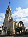
Saint-Pierre church

Festival hall of the community


Personalities
- Mathias Clemens (1915–2001), racing cyclist
- Pierre Clemens (1913–1963), racing cyclist