
Luheheide
| Luheheide and Uelzen basin | |
|---|---|
 |
|
| surface | approx. 1 360 km² |
| Systematics according to | Handbook of the natural spatial structure of Germany |
| Main unit group | 64 → Lüneburg Heath |
| 1st order natural space | North German Lowlands |
| Natural space |
643/644 → Luheheide and Uelzen basin |
| Geographical location | |
| Coordinates | 53 ° 0 '6 " N , 9 ° 39' 29" E |
 |
|
| circle | District of Harburg , district of Lüneburg , Uelzen district |
| state | Lower Saxony , Hamburg |
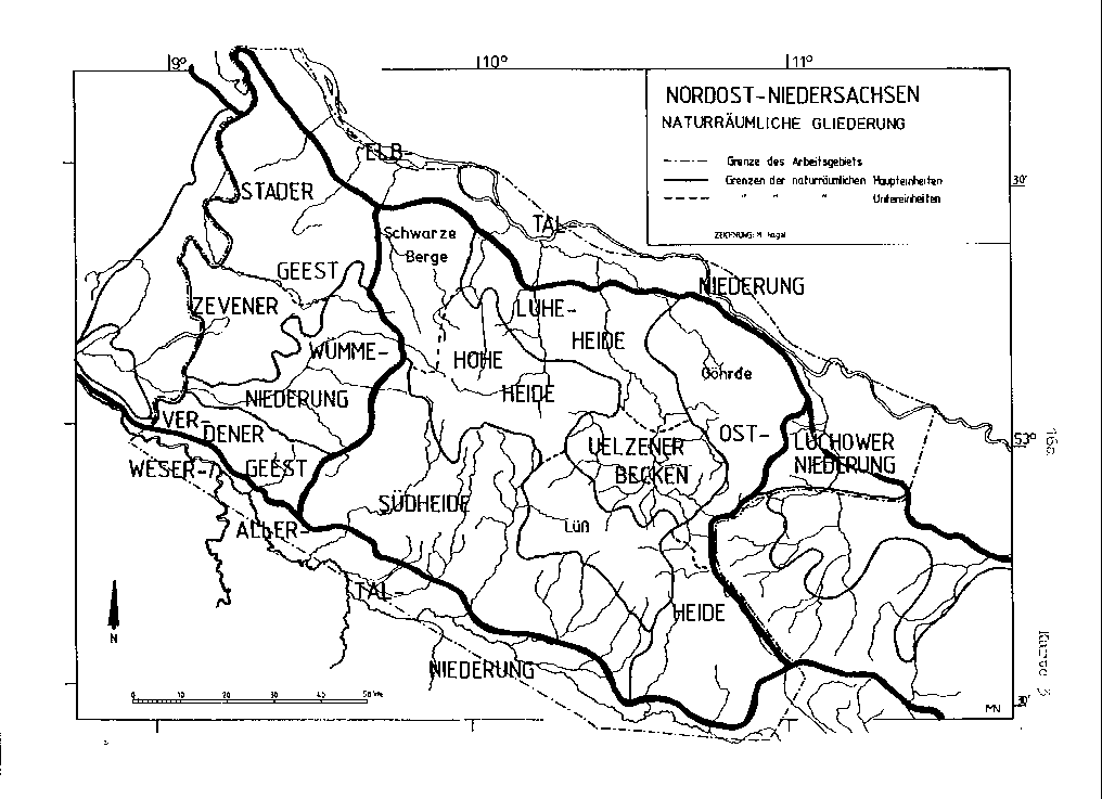
With Luheheide the North is Lüneburg Heath between the terminal moraines of Harburg Hills ( Hohe Heide ) in the west and the Elbe Lateral Canal and the Bohndorfer terminal moraines ( Ostheide hereinafter) which the treated here in the eastern part Uelzener pool is lie north. In addition to the Hoher Heide, Ostheide, Uelzener Becken and Südheide , the Luheheide is one of the five main natural areas of the Lüneburg Heath. The term Luhe heath is somewhat misleading, as in addition to the lower reaches of the central Luhe also the lower reaches of the Seeve the west and the Ilmenau in the East flow through the natural environment. These are pronounced ground moraine landscapes , which are only weakly crisscrossed by terminal moraine remnants at the seams of the partial landscapes.
The main landscapes of the Luheheide are, from west to east, the Harburger Hügelland as the eastern roofing of the Harburg Mountains between the southwest of Hamburg and Buchholz in the Nordheide , the Toppenstedter Geest with the Höllenberg between the Seeve and Luheniederung and the Lüneburg Basin on the Ilmenau around Lüneburg . It is disputed whether the Bevens Basin around Bad Bevensen and Bienenbüttel , which adjoins the Lüneburg Basin to the south, is also included or is included in the main unit of the larger Uelzen Basin around Uelzen , which is even further south .
The Westermann Lexicon of Geography from 1983 brings the Luheheide and the Uelzen Basin together as just one main unit, Nordheide . This includes, east of the Lüneburg Basin, also the western part of the Bohndorfer terminal moraines and the Neetzer Basin on the lower reaches of the Neetze near Neetze . The term Nordheide is commonly used to refer to the north-west of the heather in the Seeve and Luhe catchment areas, including the associated parts of the Hohe Heide.
Natural structure
The main units of Luheheide and Uelzen Basin are naturally divided into sub-natural areas as follows:
-
(to 64 Lüneburg Heath )
- 644 Luheheide (approx. 650 or 653 km²), from west to east, secondary from north to south:
- 644.0 → Harburger Hügelland (approx. 155 km²)
- 644.1–3 → Toppenstedter Geest and peripheral lowlands (approx. 215 km²)
- 644.1 Seeveniederung
- 644.2 Toppenstedter Geest
- 644.3 Luheniederung
- 644.4–7 → Lüneburg basin and edge heights (approx. 280 km²)
- 644.4 Dachtmisser Berge - western northern edge of the Lüneburg basin
- 644.5 Wetzer Berge - western edge of the Lüneburg basin
- 644.6 Lueneburg Basin
- Lüneburg Kalkberg ( 56 m ; singularity )
- 644.7 Grünhagener terminal moraine (approx. 40 km²) - separating moraine to the Bevens basin
- 643 Uelzen and Bevens basins (approx. 710 and 716 km²), further from north to south:
- 643.2 / 1 → Bevens basin and Emmendorfer moraines (approx. 300 km²)
- 643.2 Bevens Basin (approx. 200 km²)
- 643.1 Emmendorfer Moraine (approx. 100 km²) - separating moraine between the two tongue basins
- 643.0 → Uelzen basin (approx. 410 km²)
- 643.2 / 1 → Bevens basin and Emmendorfer moraines (approx. 300 km²)
- 644 Luheheide (approx. 650 or 653 km²), from west to east, secondary from north to south:
Harburg hill country
With Harburger Hügelland (644.0) the eastern slope of the Harburg Mountains becomes the Seeveniederung (644.1) of the Seeve near Hittfeld in the southwest of the Hanseatic city of Hamburg and in the communities Rosengarten and Seevetal , the integrated community Jesteburg and the city Buchholz in the Nordheide , all district Harburg , Lower Saxony, designated.
Elevations west of the Seeve
The following surveys of the Harburg hill country are worth mentioning (in brackets the height above sea level and below the respective natural area):
- Langer Stein ( ⊙ ; 129.0 m; near Vahrendorf ) - Harburger Hügelland
- Kiekeberg ( ⊙ ; 127.1 m; near Vahrendorf) - Harburger Hügelland
- Hill east of Sottorf ( 100.7 m ) - Harburger Hügelland
- Klecker Wald (just under 87 m ; Hünenbett in Klecker Wald ) - Harburger Hügelland
- Sundern ( 82 m ; southeast of Tötensens ) - Harburg hill country
- Hitzenberg (a good 54 m ; north-easternmost Harburg hill near Meckelfeld ) - Harburg hill country
Toppenstedter Geest and peripheral lowlands
With Toppen townspeople Geest (644.2) the Nordostabdachung is Wilseder and Garlstorfer mountains between the Seeveniederung (644.1) of the Seeve at Hittfeld in the northwest and the Luheniederung (644.3) of Luhe in Salzhausen referred to the southeast. The landscape lies entirely in the eastern half of the Harburg district . It is named after the municipality of Toppenstedt .
The Seeve flows from about 20 m above sea level. NHN near Jesteburg to about 5 m near Maschen , the Luhe from about 35 m near Oldendorf (outskirts of the district of Lüneburg ) to about 15 m near Garstedt jden Bergedorfer Marschen (670.1) the Harburger Elbmarschen (670) the Elbmarschen (67). Both lowlands are connected in the area of the Toppenstädter Geest by a peripheral lowland that stretches from southeast to northwest, from Putensen via Eyendorf , Gödenstorf , Garlstorf , Toppenstedt , Tangendorf and Brackel to Marxen . The elevations here are consistently below 50 m and are clearly dominated by the Geest ridge, which reaches 93 m on the Höllenberg south-east of Toppenstedt . The Garlstorfer Aubach , which turns east from the rim depression near Wulfsen, separates a north (west) part from this ridge, which does not exceed 73 m .
The natural area takes up almost the entire municipality of Salzhausen - only the east of Putensen and Luhmühlen are in the Luhen lowlands and Vierhöfen is at the eastern seam of the lowlands with the Dachtmisser mountains (644.4). Of the joint municipality of Hanstedt , only the north of the administrative headquarters and the places Marxen and Brackel (with Thieshope) are in the natural area. Seevetal districts such as Ohlendorf , Ramelsloh and, above all, the seamlessly merging districts of Horst and Maschen (-Heide), the largest coherent settlement in the natural area, occupy the north-west . In the east to the north is Stelle next to Ashausen , south of Ashausen, Scharmbeck and Pattensen, are two current districts of Winsen .
Elevations between Seeve and Luhe
The following surveys of the Toppenstedter Geest are worth mentioning (in brackets the height above sea level and below the respective natural area):
- Höllenberg ( 93 m ) - (southern) Toppenstedter Geest
- Hamberg ( 78 m ; AT on the northeast slope) - (southern) Toppenstedter Geest
- Brummelsberg ( 73 m ) - (northern) Toppenstedter Geest
-
Kreuzberg ( 62 m ) - (northern) Toppenstedter Geest
- Rehmenberg ( 62 m ; 1.8 km east-northeast of the Kreuzberg) - (northern) Toppenstedter Geest
- Peak in the Großer Buchwedel (almost 68 m ) - (northern) Toppenstedter Geest
- Hallonen (a good 62 m ; northern Randberg with Reiherhorst youth home ) - (northern) Toppenstedter Geest
Lüneburg basin and edge heights
The basin landscape on the Ilmenau around the Hanseatic city of Lüneburg in the district of Lüneburg , Lower Saxony, is called the Lüneburg Basin (644.6) .
The Lüneburg Basin has a total of only five, z. Sometimes quite narrow transitions to neighboring basins and lowlands and is limited by the following edge heights (counterclockwise, starting in the western north, heights above sea level ):
-
Dachtmisser Berge (up to 68 m ), western limit to the north
- ↓ Brümbach (to the west to Luhe ) near Westergellersen (around 40 m ); Northwest
- (northern) Wetzer Mountains (up to 91 m ); West boundary
- (Eastern) Wetzer Mountains (up to 87 m ); western limit to the south
- ↓ Entry of the Barnstedt-Melbeck brook near Kolkhagen (around 25 m ); south
-
Grünhagener terminal moraines (southwest wing; up to 84 m ); South boundary
- ↓ Entry of the Ilmenau above Melbeck (by 15 m ); southeast
- Grünhagener terminal moraines (northeast wing; up to 78 m ); Southeast boundary
-
Elbe Lateral Canal (here 42 m ), behind it Bohndorfer terminal moraines , Ostheide (here up to 91 m ); East limit
- ↓ Escape of the Ilmenau west of Adendorf (by 5 m ), east north
While the breakthrough valley of the Ilmenau to the basin is narrow and accompanied by steep slopes, the cleared depression at Kolkhagen looks like the actual drainage of an interglacial tongue basin .
The Dachtmisser Mountains (644.4) and the Wetzer Mountains (644) are mixed landscapes of ground moraines with remnants of terminal moraine. The core area of the Dachtmisser Berge, which forms a ridge in a west-east direction , is the uninterrupted forest area Hohe Linde , which encompasses 19 km² in the natural area, but also continues to the north into the Elbmarschen . The Wetzer Mountains are shown opposite on sheet Hamburg (South) as a strip extending from north to south with a constant, narrow width in the transverse direction. This does not quite apply to the geomorphology and today's vegetation. Rather, the forest mountains around Wetzen surround the basin in a sickle shape, with a wooded ridge north of the village (core forest: 13 km²) and a second, which extends to the southeast with an island-like clearing around ( Embsen -) Heinsen (23 km² minus clearing islands) . The eastern Wetzer Mountains separate Marxen am Berge , Drögennindorf and Betzendorf on the edge of the Süsing or its direct foothills from the core basin.
From the ridge line of the terminal moraine remains between Bohndorfer terminal moraine and Süsing, Kolkhagen would still be just in the Lüneburg Basin, while the mother community of Barnstedt was already in the Bevens Basin (643.2) to the southeast . The map of Blatt Lüneburg, however, places the border on the low water divide between Barnstedt-Melbecker Bach and Eitzer Bach or middle Ilmenau, which is why Barnstedt is still shown there as a peripheral location. However, the watershed is only 39 m high and practically imperceptible in the terrain.
The Grünhagener terminal moraines (644.7) on the border between the district of Lüneburg and the district of Uelzen , named after ( Bienenbüttel -) Grünhagen on the Bevens side of the breakthrough valley, are forested on about 26 km² and thus two thirds of their area; Also along the Ilmenau breakthrough valley, the clearing is just 100 m wide and just above it. The slopes to the Bevens Basin are steep, those to the Lüneburger are only in the northeast of the northeast wing, between Deutsch and Wendisch Evern . To the south of Wendisch Evern, in the saddle that reaches down to 36 m between the two main peaks of the wing, each reaching 78 m , namely the Timeloberg in the north-west and the Klötzenberg in the south-east, there is the Wendisch Evern training area , where Heinrich Himmler is buried. At 84 m on the Eitzener Berg, the southwest wing is slightly higher than the northeast wing.
The transition from the Grünhagener to the Bohnhagener terminal moraines (642.7) and thus the Ostheide is actually flowing; however, today the Elbe Lateral Canal forms a comparatively sharp landscape boundary. Further north, where it runs directly on the edge of the basin, it is also largely the western tree line, which makes it all the more the current landscape border.
In the core basin, in addition to the city of Lüneburg, all core locations of the joint municipality of Ilmenau are located except Barnstedt in the south, all core locations of the joint municipality of Gellersen in the west, Wendisch Evern in the east and Vögelsen and Adendorf in the northern outskirts . Outside the Hanseatic city there are scattered island-like groves, in the city itself in the 56 m high Kalkberg there is a natural spatial singularity .
Elevations and heights of the Lüneburg Basin
The following elevations and marginal mountains (those from neighboring main units in small letters) of the Lüneburg basin are worth mentioning (the height above sea level in brackets and the respective natural area below):
- Hambornsberg (just under 91 m ; west of Südergellersen ) - (northern) Wetzer Mountains
- The birch trees ( 91 m ; immediately southeast of Barendorf , interface to the Grünhagen terminal moraines) - Bohndorfer terminal moraines, Ostheide
-
Fuchsberge ( 87 m ; outermost south-west frame of the Lüneburg basin, near the interface with Süsing; on the other hand, west-south-west extension of the Grünhagen terminal moraines separated by a depression) - (eastern) Wetzer Mountains
- Brünsberg ( 85.5 m ; immediately southwest of the Fuchsberge) - (eastern) Wetzer Berge
- Steinhöhe ( 86 m ; eastern Stadtberg Lüneburg ) - Bohndorfer terminal moraines
- Eitzener Berg ( 84 m ) - Grünhagener terminal moraines (southwest wing)
- Rough mountains ( 80 m , north-northwest foothills of the Süsing southeast of Salzhausen ) - (northern) Wetzer Mountains
- Timeloberg ( 78 m ) - Grünhagener terminal moraines (northeast wing, north side)
- Escherberg (just under 74 m ; at the interface to Süsing and Lopauer Switzerland, east of Wetzens ) - (eastern) Wetzer Mountains
- On the Hohenfelde ( 68 m , north of Dachtmissens ) - Dachtmisser Berge
- Osterberg ( 67 m ; southwestern edge of the Lüneburg Basin) - (eastern) Wetzer Mountains
- Galgenberg ( 65 m ) - Grünhagener terminal moraines (southwest wing, north side)
- Tappenshöhe ( 64 m ) - Dachtmisser Berge
- Central mountain of the Dachtmisser Berge (almost 64 m ) - Dachtmisser Berge
- Black Heath ( 61 m ; western Lüneburg Basin) - Lüneburg Basin
- Ohberg (just under 61 m ; interface between the Dachtmisser Mountains and the Wetzer Mountains east of Westergellersen ) - Dachtmisser Berge
- Lüneburg Kalkberg ( 56 m ) - Singularity in the Lüneburg Basin (western part)
Bevenser basin and Emmendorfer moraines
Elevations and heights of the edge of the Bevens basin
The following elevations and marginal mountains (those from neighboring main units in small letters) of the Bevens Basin are worth mentioning (the height above sea level in brackets and the respective natural area below):
- Eschenberg ( 109 m ; near Hohenbünstorf ) - Emmendorfer Moränen (west wing)
- Hellkuhlenberg ( 108.3 m ; northeast of the Süsing main forest area, near the L 233) - Süsing end moraine, Hohe Heide
- Fechtenberg ( 104 m ; west of Göhrde, northeast of Himbergens ) - Göhrde, Ostheide
- Lindenberg ( 102 m ; east of Barums , directly at the breakthrough of the Ilmenau ) - Emmendorfer Moränen (west wing)
- Schierbusch (a good 100 m ; eastern Süsing edge height southeast ( Hanstedt -) Velgens , beyond the L 233) - Süsing end moraine
- Hohe Berge ( 99 m ; western Drawehn-Randberg) - Hohe Geest, Ostheide
- Sieckerberg ( 97.2 m ) - Bohndorfer terminal moraines, Ostheide
- Hill in Wiebeck ( 96 m ; north of Groß Thondorf ; connected to the Göhrde to the southeast) - Bohndorfer terminal moraine, Ostheide
- Fuchsberg ( 93 m ; northwest of Wiebeck) - Bohndorfer terminal moraines
- Sandberg ( 92 m ; western foothills of the Göhrde north of Himbergens) - Göhrde
- Wiernitzberg ( 92 m ; immediately west of the Göhrde) - Bohndorfer terminal moraines
- Tiedkenberg ( 83 m ; western Drawehn-Randberg) - Hohe Geest
- Eitzener Berg ( 84 m ) - Grünhagener terminal moraines (west wing)
- Hill in the Mührgehege ( 83 m ; west-northwest of Oetzens ) - Emmendorfer Moränen (east wing)
- Tiedkenberg ( 83 m ; western Drawehn-Randberg) - Hohe Geest
- Häsekenberg ( 83 m ) - Bevens Basin (eastern part)
- Thondorfer Berg ( 80 m ) - Bevenser Basin (eastern part)
- Weißer Berg ( 80 m ; Doppelkuppe, northern slightly higher) - Bevens Basin (eastern part)
- Hill near Vastorf - Gifkendorf ( 78 m ) - Bohndorfer terminal moraines
- Klötzenberg ( 78 m ) - Grünhagener terminal moraines (east wing, south side)
- Schäferberg (a good 76 m ; extreme east of the basin) - Bevens basin (eastern part)
- Weißer Berg ( 80 m ; Doppelkuppe, northern slightly higher) - Bevens Basin (eastern part)
- Hochberg ( 80 m ; Doppelkuppe, southern slightly higher) - Bevens Basin (eastern part)
- Heisterberg ( 74 m ; Randberg of the Uelzen Basin and the Ilmenau Gorge) - Emmendorfer Moränen (east wing)
- On the location (almost 72 m ; central Bevens Basin, immediately east of Bad Bevensen , Ilmenau and Canal) - Bevens Basin (eastern part)
- Eichenberg (a good 70 m ) - Bevens Basin (western part)
- Hahnenberg ( 58 m ; cultural monument in the northeast of the basin) - Bevens basin (eastern part)
Uelzen basin
Elevations and heights of the Uelzen basin
The following elevations and marginal mountains (those from neighboring main units in small letters) of the Uelzen basin are worth mentioning (the height above sea level in brackets and the respective natural area below):
- Wierener Berge (almost 136 m ; Lüß-Randberg, which protrudes like a peninsula into the Uelzen basin, southwest of Wieren ; the highest peak is called Hoher Berg ) - Lüßmoränen, Hohe Heide
- Blauer Berg ( 128 m ; Lüß-Randberg, which protrudes like a peninsula into the Uelzen basin, southeast of Suderburg ) - Lüßmoränen
-
Fuchsberge ( 116 m ; 5 km east of Suhlendorf ) - Hohe Geest, Ostheide
- Mallätzer Berg ( 82 m ; southwest foothills to the edge of the Uelzen basin)
- Eschenberg ( 109 m ; near Hohenbünstorf ) - Emmendorfer Moränen (west wing)
- Kronsberg ( 105 m ; one of various peaks northeast of the Fuchsberge) - Hohe Geest
- Lindenberg ( 102 m ; east of Barums , directly at the breakthrough of the Ilmenau ) - Emmendorfer Moränen (west wing)
-
Bosenberg ( 93 m ; Lüß-Randberg northeast of the railway, immediately west of Ebstorf ) - Lüßmoränen
- Bullenberg ( 78 m , south-southwest foothills)
- Lerchenberg ( 92 m ; east Lüß-Randberg west of Böddenstedts ) - Lüßmoränen
- Luisenhöhe ( 87 m ; western edge mountain of Drawehn) - Hohe Geest
- Ringenberg ( 85 m ; edge height immediately west of the Blue Mountain) - Uelzen basin
-
Weißer Berg ( 85 m ; western edge mountain of Drawehn) - Hohe Geest
- Wachtberg ( 79 m ) - southwest foothills
- Hasselberg ( 71 m ) - western foothills
- Schlaminsberge (just under 84 m ; south-eastern edge of the basin at the interface with the Lüß) - Bodenteicher Geest, Ostheide
- Blauer Berg (just under 84 m ; south-eastern edge of the pool) - Bodenteicher Geest
- Hill in the Mührgehege ( 83 m ; west-northwest of Oetzens ) - Emmendorfer Moränen (east wing)
- Buchenberg ( 78 m ; west of Uelzen ) - Uelzen basin (western part)
- Heisterberg ( 74 m ; Randberg of the Uelzen Basin and the Ilmenau Gorge) - Emmendorfer Moränen (east wing)
- Vossberg ( 74 m ; westernmost mountain of Drawehn) - Hohe Geest
More global surveys
The following elevations of the Luheheide and the Uelzen basin are the highest mountain of an orographic partial mountain range or at least particularly dominant , (at least one side) prominent or singular (in brackets the height above sea level and subsequently the respective natural area):
- Eschenberg ( 109 m ; near Hohenbünstorf ) - Emmendorfer Moränen (west wing)
- Hill east of Sottorf ( 100.7 m ) - Harburger Hügelland
- Höllenberg ( 93 m ) - (southern) Toppenstedter Geest
- Hambornsberg (just under 91 m ; west of Südergellersen ) - (northern) Wetzer Mountains
- Fuchsberge ( 87 m ; extreme south-west frame of the Lüneburg Basin, near the interface with Süsing; on the other hand, west-south-west extension of the Grünhagen terminal moraines separated by a depression) - (eastern) Wetzer Mountains
- Häsekenberg ( 83 m ) - Bevens Basin (eastern part)
- Hill in the Mührgehege ( 83 m ; west-northwest of Oetzens ) - Emmendorfer Moränen (east wing)
- Buchenberg ( 78 m ; west of Uelzen ) - Uelzen basin (western part)
- Timeloberg ( 78 m ) - Grünhagener terminal moraines (east wing, north side)
- Klötzenberg ( 78 m ) - Grünhagener terminal moraines (east wing, south side)
- Brummelsberg ( 73 m ) - (northern) Toppenstedter Geest
- On the Hohenfelde ( 68 m , north of Dachtmissens ) - Dachtmisser Berge
- Lüneburg Kalkberg ( 56 m ) - Singularity in the Lüneburg Basin (western part)
Individual evidence
- ↑ Sketch of a map according to the Westermann Lexicon of Geography from 1983 (ill. P. 541) in a master's thesis by Martin Nagel
- ^ Emil Meynen , Josef Schmithüsen et al .: Handbook of the natural spatial structure of Germany . Federal Institute for Regional Studies, Remagen / Bad Godesberg 1953–1962 (9 deliveries in 8 books, updated map 1: 1,000,000 with main units 1960).
- ↑ a b c d Sofie Meisel: Geographical land survey: The natural spatial units on sheet 57 Hamburg-Süd. Federal Institute for Regional Studies, Bad Godesberg 1964. → Online map (PDF; 4.4 MB)
- ↑ a b Wolfgang Meibeyer : Geographical land survey: The natural spatial units on sheet 58 Lüneburg. Federal Institute for Regional Studies, Bad Godesberg 1980. → Online map (PDF; 4.8 MB)
- ↑ Wolfgang Meibeyer : Geographical Land Survey: The natural spatial units on sheet 74 Salzwedel. Federal Institute for Regional Studies, Bad Godesberg 1970. → Online map (PDF; 4.7 MB)
- ↑ a b c d e f g h i j k l m n Polygon measurement according to the course on the single sheets
- ↑ Luheheide landscape profile ( memento of the original from March 16, 2014 in the Internet Archive ) Info: The archive link has been inserted automatically and has not yet been checked. Please check the original and archive link according to the instructions and then remove this notice. (644) of the BfN
- ↑ Without Raven, which was strangely included in the Geest on sheet Hamburg (South ), but already clearly belongs to the Garlstorfer Mountains due to its altitude (around 100 m , wooded steep slopes to the east)
- ↑ With the southwestern outskirts (clockwise) Barnstedt, Betzendorf, Drögennindorf, settlement Drögennindorf and along 60 to 70 m altitude to the south of Wetzens
- ^ Title of sheet Lüneburg; the ten years older sheet Salzwedel by the same author uses the designation Uelzen Basin and Ilmenauniederung , as does the manual nine years older (7th edition) .
- ↑ Uelzen and Bevens Basin landscape profile ("Uelzen Basin") ( Memento of the original from March 16, 2014 in the Internet Archive ) Info: The archive link was automatically inserted and not yet checked. Please check the original and archive link according to the instructions and then remove this notice. (643) of the BfN
- ↑ The Heisterberg ( 74 m ) on the northern edge, to the right of the Ilmenau, was counted as one of the Emmendorfer terminal moraines during the measurement.
- ↑ a b Map services of the Federal Agency for Nature Conservation ( information )
- ↑ a b Sottorf and hill ( memento of the original from February 21, 2017 in the Internet Archive ) Info: The archive link was inserted automatically and has not yet been checked. Please check the original and archive link according to the instructions and then remove this notice. at the DTK 25
- ↑ The Hünenbettgebiet in Klecker Wald ( memento of the original from February 21, 2017 in the Internet Archive ) Info: The archive link was automatically inserted and not yet checked. Please check the original and archive link according to the instructions and then remove this notice. on AK 2.5
- ↑ Der Sundern ( Memento of the original from February 21, 2017 in the Internet Archive ) Info: The archive link was inserted automatically and has not yet been checked. Please check the original and archive link according to the instructions and then remove this notice. on AK 2.5
- ↑ Der Hitzenberg ( Memento of the original from February 21, 2017 in the Internet Archive ) Info: The archive link was automatically inserted and not yet checked. Please check the original and archive link according to the instructions and then remove this notice. on AK 2.5
- ↑ a b Der Höllenberg ( Memento of the original from November 14, 2016 in the Internet Archive ) Info: The archive link was inserted automatically and has not yet been checked. Please check the original and archive link according to the instructions and then remove this notice. on DTK 50
- ↑ Der Hamberg ( Memento of the original from April 24, 2014 in the Internet Archive ) Info: The archive link was inserted automatically and has not yet been checked. Please check the original and archive link according to the instructions and then remove this notice. on DTK 50
- ↑ a b Der Große Brummelsberg ( Memento of the original from April 24, 2014 in the Internet Archive ) Info: The archive link was inserted automatically and has not yet been checked. Please check the original and archive link according to the instructions and then remove this notice. on AK 2.5
- ↑ Der Kreuzberg und Rehmenberg ( Memento of the original from April 24, 2014 in the Internet Archive ) Info: The archive link was inserted automatically and has not yet been checked. Please check the original and archive link according to the instructions and then remove this notice. on DTK 50
- ↑ Der Große Buchwedel ( Memento of the original from April 24, 2014 in the Internet Archive ) Info: The archive link was inserted automatically and has not yet been checked. Please check the original and archive link according to the instructions and then remove this notice. on AK 2.5
- ↑ Hallonen ( Memento of the original from April 24, 2014 in the Internet Archive ) Info: The archive link was inserted automatically and has not yet been checked. Please check the original and archive link according to the instructions and then remove this notice. on DTK 25
- ↑ a b Der Hambornsberg ( Memento of the original from February 21, 2017 in the Internet Archive ) Info: The archive link was automatically inserted and not yet checked. Please check the original and archive link according to the instructions and then remove this notice. on DTK 50; ÜKN 500 shows "91 m"
- ↑ Die Birken ( Memento of the original from April 24, 2014 in the Internet Archive ) Info: The archive link was inserted automatically and has not yet been checked. Please check the original and archive link according to the instructions and then remove this notice. on AK 2.5
- ↑ a b c Die Fuchsberge ( Memento of the original from April 24, 2014 in the Internet Archive ) Info: The archive link was inserted automatically and has not yet been checked. Please check the original and archive link according to the instructions and then remove this notice. next to Brünsberg on DTK 25; on AK 2.5 and TK 100 the height of 87 m is displayed
- ↑ Die Steinhöhe ( Memento of the original from April 24, 2014 in the Internet Archive ) Info: The archive link was inserted automatically and has not yet been checked. Please check the original and archive link according to the instructions and then remove this notice. on AK 2.5; 86.0 m are shown on TK 10 (BfN Service Protected Areas); on a coarser scale it is mostly only 83 m
- ↑ a b c Eitzener Berg and Galgenberg ( Memento of the original from April 24, 2014 in the Internet Archive ) Info: The archive link was inserted automatically and has not yet been checked. Please check the original and archive link according to the instructions and then remove this notice. on TK 100
- ↑ a b c d Timelo- und Klötzenberg ( Memento of the original from April 24, 2014 in the Internet Archive ) Info: The archive link was inserted automatically and has not yet been checked. Please check the original and archive link according to the instructions and then remove this notice. on the DTK 100
- ↑ Der Escherberg ( Memento of the original from April 29, 2014 in the Internet Archive ) Info: The archive link has been inserted automatically and has not yet been checked. Please check the original and archive link according to the instructions and then remove this notice. on TK 100
- ↑ a b Auf dem Hohenfelde ( Memento of the original from April 24, 2014 in the Internet Archive ) Info: The archive link was automatically inserted and not yet checked. Please check the original and archive link according to the instructions and then remove this notice. on AK 5
- ↑ Der Osterberg ( Memento of the original of April 24, 2014 in the Internet Archive ) Info: The archive link was automatically inserted and not yet checked. Please check the original and archive link according to the instructions and then remove this notice. on the DTK 50
- ↑ The tap height ( page no longer available , search in web archives ) Info: The link was automatically marked as defective. Please check the link according to the instructions and then remove this notice. on AK 5
- ↑ Der Berg ( Memento of the original from March 6, 2016 in the Internet Archive ) Info: The archive link was inserted automatically and has not yet been checked. Please check the original and archive link according to the instructions and then remove this notice. on AK 2.5
- ↑ Die Schwarze Heide ( Memento of the original from September 4, 2017 in the Internet Archive ) Info: The archive link was inserted automatically and has not yet been checked. Please check the original and archive link according to the instructions and then remove this notice. on AK 5
- ↑ Der Ohberg ( Memento of the original from March 6, 2016 in the Internet Archive ) Info: The archive link was inserted automatically and has not yet been checked. Please check the original and archive link according to the instructions and then remove this notice. on AK 2.5
- ↑ a b c Der Eschenberg ( Memento of the original from April 24, 2014 in the Internet Archive ) Info: The archive link was inserted automatically and has not yet been checked. Please check the original and archive link according to the instructions and then remove this notice. on AK 5
- ↑ a b View of the western Göhrde with the Fechtenberg and the Sandberg (west) ( Memento of the original from April 24, 2014 in the Internet Archive ) Info: The archive link was automatically inserted and not yet checked. Please check the original and archive link according to the instructions and then remove this notice. on TK 100
- ↑ a b Der Lindenberg ( Memento of the original from April 24, 2014 in the Internet Archive ) Info: The archive link was inserted automatically and has not yet been checked. Please check the original and archive link according to the instructions and then remove this notice. on the AK 2.5
- ↑ Der Schierbusch ( Memento of the original from April 24, 2014 in the Internet Archive ) Info: The archive link was inserted automatically and has not yet been checked. Please check the original and archive link according to the instructions and then remove this notice. on the AK 5
- ↑ The High Mountains ( Memento of the original from April 24, 2014 in the Internet Archive ) Info: The archive link was inserted automatically and has not yet been checked. Please check the original and archive link according to the instructions and then remove this notice. on AK 2.5
- ↑ The Sieckerberg ( Memento of the original from April 24, 2014 in the Internet Archive ) Info: The archive link was automatically inserted and not yet checked. Please check the original and archive link according to the instructions and then remove this notice. on DTK 50
- ↑ a b Der Wiebeck ( Memento of the original from April 24, 2014 in the Internet Archive ) Info: The archive link was inserted automatically and has not yet been checked. Please check the original and archive link according to the instructions and then remove this notice. on TK 100
- ↑ The Wiernitzberg, as also the place Groß Thondorf , on the map of Lüneburg sheet still just assigned to the Bevenser pool; however, both are one level above the actual basin.
- ↑ Der Wiernitzberg ( Memento of the original from April 24, 2014 in the Internet Archive ) Info: The archive link was inserted automatically and has not yet been checked. Please check the original and archive link according to the instructions and then remove this notice. on DTK25; The height is visible on AK 2.5, where the name Strothberg is entered
- ↑ Der Tiedkenberg ( Memento of the original from April 24, 2014 in the Internet Archive ) Info: The archive link was inserted automatically and has not yet been checked. Please check the original and archive link according to the instructions and then remove this notice. on AK 2.5
- ↑ a b c The Mührgehege ( Memento of the original from April 24, 2014 in the Internet Archive ) Info: The archive link was inserted automatically and has not yet been checked. Please check the original and archive link according to the instructions and then remove this notice. on the DTK 25 - DTK 50 explicitly states the height.
- ↑ Der Tiedkenberg ( Memento of the original from April 24, 2014 in the Internet Archive ) Info: The archive link was inserted automatically and has not yet been checked. Please check the original and archive link according to the instructions and then remove this notice. on AK 2.5
- ↑ a b c d e f Häsekenberg, Thondorfer Berg, Weißer Berg and Hochberg ( Memento of the original from April 24, 2014 in the Internet Archive ) Info: The archive link was inserted automatically and has not yet been checked. Please check the original and archive link according to the instructions and then remove this notice. on the TK 100 - on AK 2.5 the heights are visible (except for the Häselenberg, where only 81 m are displayed here)
- ↑ Gifkendorf and hill ( memento of the original from April 24, 2014 in the Internet Archive ) Info: The archive link was inserted automatically and has not yet been checked. Please check the original and archive link according to the instructions and then remove this notice. on TK 100
- ↑ Der Schäferberg ( Memento of the original from April 24, 2014 in the Internet Archive ) Info: The archive link was inserted automatically and has not yet been checked. Please check the original and archive link according to the instructions and then remove this notice. at the DTK 25
- ↑ a b Der Heisterberg ( Memento of the original from April 24, 2014 in the Internet Archive ) Info: The archive link was inserted automatically and has not yet been checked. Please check the original and archive link according to the instructions and then remove this notice. on the TK 100
- ↑ Auf der Lage ( Memento of the original from April 24, 2014 in the Internet Archive ) Info: The archive link was inserted automatically and has not yet been checked. Please check the original and archive link according to the instructions and then remove this notice. on AK 2.5
- ↑ Der Eichenberg ( Memento of the original from April 24, 2014 in the Internet Archive ) Info: The archive link was inserted automatically and has not yet been checked. Please check the original and archive link according to the instructions and then remove this notice. on DTK 25
- ↑ Der Hahnenberg ( Memento of the original from April 24, 2014 in the Internet Archive ) Info: The archive link was inserted automatically and has not yet been checked. Please check the original and archive link according to the instructions and then remove this notice. on the DTK 50
- ↑ a b Wierener Berge and Blauer Berg ( Memento of the original from February 21, 2017 in the Internet Archive ) Info: The archive link has been inserted automatically and has not yet been checked. Please check the original and archive link according to the instructions and then remove this notice. on TK 100
- ↑ a b Fuchsberge and Kronsberg ( Memento of the original from April 25, 2014 in the Internet Archive ) Info: The archive link was inserted automatically and has not yet been checked. Please check the original and archive link according to the instructions and then remove this notice. on TK 100
- ↑ The Bosenberg and its foothills ( memento of the original from February 21, 2017 in the Internet Archive ) Info: The archive link was automatically inserted and not yet checked. Please check the original and archive link according to the instructions and then remove this notice. on TK 100
- ↑ Der Lerchenberg ( Memento of the original from February 21, 2017 in the Internet Archive ) Info: The archive link has been inserted automatically and has not yet been checked. Please check the original and archive link according to the instructions and then remove this notice. on TK 100
- ↑ The Luisenhöhe ( Memento of the original from April 25, 2014 in the Internet Archive ) Info: The archive link was inserted automatically and has not yet been checked. Please check the original and archive link according to the instructions and then remove this notice. on DTK 50
- ↑ Der Ringenberg ( Memento of the original from April 25, 2014 in the Internet Archive ) Info: The archive link was inserted automatically and has not yet been checked. Please check the original and archive link according to the instructions and then remove this notice. on DTK 50
- ↑ The White Mountain and its Foothills ( Memento of the original from April 25, 2014 in the Internet Archive ) Info: The archive link was inserted automatically and has not yet been checked. Please check the original and archive link according to the instructions and then remove this notice. on DTK 50
- ↑ The Schlaminsberge ( Memento of the original from April 25, 2014 in the Internet Archive ) Info: The archive link has been inserted automatically and has not yet been checked. Please check the original and archive link according to the instructions and then remove this notice. on AK 2.5
- ↑ Der Blaue Berg ( Memento of the original from April 25, 2014 in the Internet Archive ) Info: The archive link was inserted automatically and has not yet been checked. Please check the original and archive link according to the instructions and then remove this notice. on DTK 25
- ↑ a b Der Buchenberg ( Memento of the original from April 24, 2014 in the Internet Archive ) Info: The archive link was inserted automatically and has not yet been checked. Please check the original and archive link according to the instructions and then remove this notice. on DTK 50
- ↑ Der Voßberg ( Memento of the original from April 24, 2014 in the Internet Archive ) Info: The archive link was automatically inserted and not yet checked. Please check the original and archive link according to the instructions and then remove this notice. on AK 2.5; the mountain name becomes visible on a coarser scale