Lapalud
| Lapalud | ||
|---|---|---|

|
|
|
| region | Provence-Alpes-Cote d'Azur | |
| Department | Vaucluse | |
| Arrondissement | Carpentras | |
| Canton | Bollène | |
| Community association | Rhône Lez Provence | |
| Coordinates | 44 ° 18 ′ N , 4 ° 41 ′ E | |
| height | 42-59 m | |
| surface | 17.37 km 2 | |
| Residents | 3,805 (January 1, 2017) | |
| Population density | 219 inhabitants / km 2 | |
| Post Code | 84840 | |
| INSEE code | 84064 | |
| Website | http://www.mairie-lapalud.fr/ | |
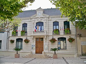
 Lapalud Town Hall |
||
Lapalud is a French municipality with 3805 inhabitants (at January 1, 2017) in the department of Vaucluse in the region Provence-Alpes-Cote d'Azur . It belongs to the Arrondissement Carpentras and the Canton of Bollène . The inhabitants are called Lapalucia (ne) s .
geography
Lapalud is the westernmost municipality in the Vaucluse department. It is located in the Tricastin countryside in Provence . The Rhône limits the municipality to the west. Lapalud is surrounded by the neighboring communities of Pierrelatte in the north, Bollène in the east, Lamotte-du-Rhône in the south, Saint-Just-d'Ardèche in the southwest and Saint-Marcel-d'Ardèche in the west.
The National Route 7 runs through the municipality .
Population development
| year | 1962 | 1968 | 1975 | 1982 | 1990 | 1999 | 2006 | 2017 |
|---|---|---|---|---|---|---|---|---|
| Residents | 1477 | 2345 | 2260 | 3133 | 3332 | 3267 | 3425 | 3805 |
|
source
|
||||||||
Attractions
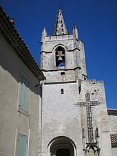
- Saint-Pierre-aux-Liens church, partly built in the 13th century in Romanesque style, bell tower from the 15th century, monument historique since 1973
- Cardinal house, residence of cardinals during the seat of the (anti-) Pope in Avignon
- Town hall from 1911
Personalities
- Joseph Louis Victor Jullien de Bidon (1764–1839), general
- Rodolphe Julian (1839–1907), painter
Web links
Commons : Lapalud - collection of images, videos and audio files
Individual evidence
- ↑ INSEE ( page no longer available , search in web archives ) Info: The link was automatically marked as defective. Please check the link according to the instructions and then remove this notice. , accessed September 5, 2014

