
Monieux
| Monieux | ||
|---|---|---|
.svg)
|
|
|
| region | Provence-Alpes-Cote d'Azur | |
| Department | Vaucluse | |
| Arrondissement | Carpentras | |
| Canton | Pernes-les-Fontaines | |
| Community association | Ventoux Sud | |
| Coordinates | 44 ° 4 ′ N , 5 ° 22 ′ E | |
| height | 439–1,022 m | |
| surface | 47.12 km 2 | |
| Residents | 317 (January 1, 2017) | |
| Population density | 7 inhabitants / km 2 | |
| Post Code | 84390 | |
| INSEE code | 84079 | |
 View of Monieux |
||

Monieux is a French municipality with 317 inhabitants (at January 1, 2017) in the department of Vaucluse in the region Provence-Alpes-Cote d'Azur .
Two dedicatory inscriptions for the Gallo-Roman local god Mars Nabelcus were found in Monieux .
geography
Monieux is located at the foot of the mountain range, to which Mont Ventoux also belongs, in the Sault plateau , the Plateau d'Albion . This is where the Gorges de la Nesque begin , which the river Nesque has dug up to 400 meters deep into the mountains. The D 942 road from Villes-sur-Auzon to Sault runs through the gorge and through Monieux.
Population development
| year | 1962 | 1968 | 1975 | 1982 | 1990 | 1999 | 2008 |
|---|---|---|---|---|---|---|---|
| Residents | 139 | 152 | 122 | 171 | 158 | 250 | 344 |
Attractions
City wall and watchtower

Following the example of most medieval villages, a surrounding wall was also built in Monieux in the 12th century . Taking into account the particular location of the village, which is overlooked by a rock wall, the city walls do not form a circle that surrounds the village, but a kind of collar, the two ends of which converge on both sides of the cliff. Of the three original gates in the wall, only the Portail Meunier at the south-western end of the village has survived.
This defense system was completed by a watchtower located on the top of the cliff. It is still in ruins and has lost about half of its original height over time. It was part of a system of towers to protect the Sault Valley, of which only a few towers have survived. The closest is that of Saint-Jean-de-Sault , the outline of which can be seen from the village of Monieux.
Sacred buildings
church
The parish church of Saint-Pierre, located outside the city walls, was built in the 12th century. Over time, the original apse has disappeared. Various additions and changes (raising the floor, building side chapels in the 17th and 18th centuries, etc.) have redesigned the church, only the choir has retained a magnificent trumpet dome from its Romanesque origins .
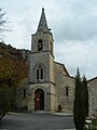
Parish Church of Monieux
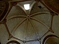
Trumpet dome


Chapels
- Champ de Sicaude
Located near the impressive Rocher du Cire, this chapel was built in 1713, at a time when the hamlet of Champ de Sicaude was home to many working farms. Later converted into a school, today only a few parts of the collapsed walls and a bell that was found by chance in the middle of the stones and carefully preserved by the community are preserved.
- Notre-Dame-de-la-Consolation

This chapel is also erroneously called Notre-Dame-des-Abeilles after the hamlet at this location. The exact date of construction of the chapel is unknown; it was first mentioned in the 17th century and underwent restoration at the beginning of the 18th century. Every year on August 15, a service is held in the chapel to commemorate the pastor of Abeilles, Joseph Thouard (1825–1888), who selflessly cared for the sick and invented a famous elixir.
- Saint-André
The Romanesque chapel, of which only a ruin remains, was built on a rock near the watchtower above Monieux and was still in use before the last world war .
- Saint-Michel-de-la-Nesque

This rock chapel of Romanesque origin, which lies at the foot of the Nesque Gorge and is protected by an imposing rock mass, was the destination of a pilgrimage on the day of its patron saint even before the war . She was once dependent on the Montmajour Priory . According to the stone inscriptions in front of the entrance hall, it was rebuilt several times over the centuries, especially in 1643. A nearby rock cavity housed a hermitage until the middle of the 19th century .
- Saint-Roch
The chapel, built in honor of the plague saint Saint Rochus , is located in the middle of the cedar forest opposite the village. It was built in 1852 on the site of an older chapel that was built after the plague of 1629, expanded and restored during the plague of 1720, and destroyed during the revolution . Every year, on the second Sunday in August, it is the destination of a pilgrimage in which the inhabitants of Monieux take part.
Crosses and oratorios
Three crosses marked the processions to the parish church. One is made of wood at the Portail Meunier, another made of wrought iron at the lower end of the village, above the Fontaine du Moulin, and the third is at the northeast entrance of Monieux, at the foot of a large chestnut tree.
Two oratories in the form of chapels, donated by the inhabitants of Monieux, were built: one from 1858, dedicated to the Lieu-dit Oratoire and the Blessed Virgin , and the other from 1948 in the center of the village, at the foot of the path leading to the Watchtower and dedicated to Anthony of Padua .
Secular buildings
Farms
- Saint-Hubert
The Saint-Hubert farm, built in the 18th century, was originally a hunting seat of the neighboring Château de Javon . Over time, the hunt gave way to agriculture, and after this was again abandoned, the building was restored and turned into a hostel valued by hikers and horse riders .
- Lausemolan
The Lausemolan farm was built at the end of the 16th century. Isolated in the mountains at almost 900 m altitude, it is an excellent example of a mas in typical Provencal rural architecture. Abandoned after the First World War , only ruins remain today, but you can still see the farmers' apartment, various outbuildings, stables, two cisterns, a bread oven, an aiguier and the enclosure surrounded by dry stone walls around a central courtyard. where goats and sheep were kept.
Nearby you meet a group of other Aiguiers and on the way back to the farm you will find the rest of a coal pile .
Fountain

The oldest of Monieux's two fountains, called “du Moulin”, is located in the lower part of the village, on the banks of the Nesque. It is fed by a spring and can be reached via the Chemin de la Fontaine of the same name. He has a wash house where women worked their laundry with wooden bats and exchanged news until the 19th century.
However, since this fountain was far outside the village, Léon Doux, Mayor of Monieux and director of the prestigious Alcazar Theater in Marseille , decided in 1905 to equip his community with a water point in the center of the village. He had a dowser investigate and build the fountain that now bears his name in the village square. He commissioned the sculptor Pérosi to create a bronze statue depicting an allegory of Anesca (Nesque) in the form of a young girl with a jug and an arm full of ears of corn. The fountain was inaugurated on August 27, 1905 to everyone cheering.
During the last world war, Anesca almost was melted down as gun metal . Fortunately, thanks to the inhabitants of the village, it was saved and was hidden in a cave in the ravine until the end of the war, and when it was liberated it was put back on its pedestal.
Aiguiers
These basins, carved into the rock by humans, were intended to collect rainwater and serve as drinking troughs for the herds. In the vicinity of the farms they were also used for domestic purposes (hygiene, cleaning, watering the vegetable garden). Some of them are simple open cavities. Others, very complex, have an upstream impluvium and several basins or are protected by a dry stone vault that serves as a "dew capacitor". Most of the aiguiers that have been inventoried in the Monts de Vaucluse date from the 18th and 19th centuries, but some were still built in the early 20th century.
A large number of Aiguiers can be seen all over the plateau. In Monieux there are interesting examples on the Champ de Sicaude, the Lausemolan farm and the Combe de Puits Verrier.
Plague wall
In July 1720, the plague broke out in the south of Provence. Faced with the threat of the epidemic spreading, the villages of the Monts de Vaucluse decided to join forces and build a dry stone wall about twenty kilometers long and two meters high between Lagnes and Monieux. The wall, equipped with guard houses, in which the soldiers responsible for surveillance were housed, was intended to control the passages in order to prevent the spread of the disease to the north. Each village had to provide men and equipment to work and guard the wall. The result was positive, because thanks to the measures taken and the natural protection of the site, the protected areas were spared the epidemic.
Part of the wall has been restored and is now accessible to walkers. In the municipality of Monieux, the remains of it can be seen near the Saint-Hubert farm.
Archaeological sites
- Bau de l'Aubesier
It has long been known that several rock shelters in the Gorges de la Nesque were already inhabited by humans in prehistoric times . The Bau de l'Aubesier, rediscovered in the 19th century, bears witness to the prolonged presence of human groups, who found there both a supply of flint for their tools and an environment favorable to their livelihood. The site is considered one of the most important deposits of the Middle Paleolithic (300,000 to 35,000 BC) in Provence and has been the subject of methodical archaeological excavations carried out by a Canadian team for about twenty years and including tools and remains from the Neanderthal period Have brought days. In order not to hinder the work of the archaeologists, this site is not open to the public.
Personalities
- Évariste de Valernes (1816–1896), painter
- Stefan Hertmans (* 1951), Belgian author
Web links
- Old official website ( Memento of March 3, 2016 in the Internet Archive ) with a lot of historical information (French)
Individual evidence
- ↑ a b c d e f g h i j k l m n o p q r s t u Découvrir le patrimoine historique. Office de Tourisme de Monieux et des Gorges de la Nesque, archived from the original on March 3, 2016 ; accessed on April 25, 2020 (French).