
Ferrassières
| Ferrassières | ||
|---|---|---|
.svg)
|
|
|
| region | Auvergne-Rhône-Alpes | |
| Department | Drôme | |
| Arrondissement | Nyons | |
| Canton | Nyons et Baronnies | |
| Community association | Ventoux Sud | |
| Coordinates | 44 ° 8 ' N , 5 ° 29' E | |
| height | 830-1,389 m | |
| surface | 29.27 km 2 | |
| Residents | 127 (January 1, 2017) | |
| Population density | 4 inhabitants / km 2 | |
| Post Code | 26570 | |
| INSEE code | 26135 | |
 Town hall (Mairie) of Ferrassières |
||

Ferrassières is a place and a community with 127 inhabitants (at January 1, 2017) in the department of Drôme in the southern French region of Auvergne Rhône-Alpes (before 2016 Rhône-Alpes ). The municipality belongs to the Arrondissement of Nyons and the canton of Nyons et Baronnies (until 2015 Séderon ).
location
Ferrassières is located about 45 kilometers east-northeast of Avignon . Ferrassières is surrounded by the neighboring communities of Barret-de-Lioure in the north and northeast, Revest-du-Bion in the east and southeast, Saint-Trinit in the south, Aurel in the west and Montbrun-les-Bains in the northwest.
Population development
| year | 1962 | 1968 | 1975 | 1982 | 1990 | 1999 | 2006 | 2013 |
|---|---|---|---|---|---|---|---|---|
| Residents | 118 | 109 | 118 | 124 | 106 | 113 | 118 | 118 |
| Sources: Cassini and INSEE | ||||||||
Attractions
- Saint-Julien-de-Brioude church
- La Gabelle Castle
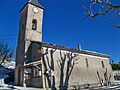
Saint-Julien-de-Brioude church
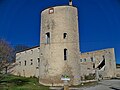
La Gabelle Castle


Web links
Commons : Ferrassières - Collection of images, videos and audio files