Curnier
| Curnier | ||
|---|---|---|
|
|
||
| region | Auvergne-Rhône-Alpes | |
| Department | Drôme | |
| Arrondissement | Nyons | |
| Canton | Nyons et Baronnies | |
| Community association | Baronnies en Drôme Provençale | |
| Coordinates | 44 ° 23 ' N , 5 ° 14' E | |
| height | 313-742 m | |
| surface | 8.00 km 2 | |
| Residents | 181 (January 1, 2017) | |
| Population density | 23 inhabitants / km 2 | |
| Post Code | 26110 | |
| INSEE code | 26112 | |
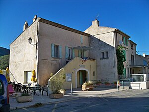
 The Mayor's Office ( Mairie ) of Curnier |
||
Curnier is a South French municipality with 181 inhabitants (at January 1, 2017) in the department of Drôme in the region Auvergne Rhône-Alpes .
geography
Curnier is about ten kilometers east of Nyons at the confluence of the Ennuye and Eygues rivers in a valley that widens strongly downstream and is characterized by vineyards and lavender, between the Baronnies in the south and the Diois in the north.
history
The area around Curnier was already settled in prehistoric times. In the Bronze Age there was an oppidum here .
The place was originally a fiefdom of the Lords of Mévouillon , in the 14th century the rule went to the Principality of Orange .
Population development
| year | 1962 | 1968 | 1975 | 1982 | 1990 | 1999 | 2009 | 2016 |
| Residents | 108 | 133 | 145 | 132 | 179 | 186 | 196 | 172 |
| Sources: Cassini and INSEE | ||||||||
Culture and sights
Curnier has a well-preserved old town center with the remains of a castle. The parish church of the village dates from the 19th century. Four vaulted niches are set into the pillars of the chapel.
Economy and Infrastructure
The main occupation in Curnier is agriculture, in which lavender, olives, wine and fruit are grown. Sheep and poultry breeding are decisive in the livestock industry. Another important agricultural product in the region is honey .
Web links
Individual evidence
