Montboucher-sur-Jabron
| Montboucher-sur-Jabron | ||
|---|---|---|
|
|
||
| region | Auvergne-Rhône-Alpes | |
| Department | Drôme | |
| Arrondissement | Nyons | |
| Canton | Montélimar-2 | |
| Community association | Montélimar agglomeration | |
| Coordinates | 44 ° 33 ' N , 4 ° 49' E | |
| height | 96-170 m | |
| surface | 9.8 km 2 | |
| Residents | 2,285 (January 1, 2017) | |
| Population density | 233 inhabitants / km 2 | |
| Post Code | 26740 | |
| INSEE code | 26191 | |
| Website | http://www.montboucher-sur-jabron.fr/ | |
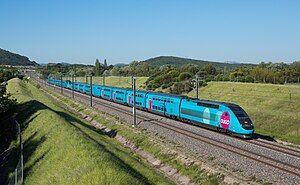
 TGV Paris-Marseille at Montboucher-sur-Jabron |
||
Montboucher-sur-Jabron is a French commune with 2,285 inhabitants (as of January 1 2017) in the department of Drôme in the region Auvergne Rhône-Alpes . Montboucher-sur-Jabron belongs to the arrondissement of Nyons and the canton of Montélimar-2 .
geography
Montboucher-sur-Jabron is on the edge of Provence on the Jabron , which also forms the southern or southeastern municipal boundary. Montboucher-sur-Jabron is surrounded by the neighboring communities Sauzet in the north, La Bâtie-Rolland in the east, Puygiron in the east and south-east, Espeluche in the south and Montélimar in the west.
The A7 autoroute runs through the municipality .
Population development
| year | 1962 | 1968 | 1975 | 1982 | 1990 | 1999 | 2006 | 2016 |
| Residents | 639 | 667 | 693 | 1042 | 1278 | 1424 | 1823 | 2273 |
Source: INSEE
Attractions
- former fort
- lock
- Fortified house
Web links
Commons : Montboucher-sur-Jabron - Collection of images, videos and audio files
