Tulette
| Tulette | ||
|---|---|---|

|
|
|
| region | Auvergne-Rhône-Alpes | |
| Department | Drôme | |
| Arrondissement | Nyons | |
| Canton | Grignan | |
| Community association | Drôme Sud Provence | |
| Coordinates | 44 ° 17 ′ N , 4 ° 56 ′ E | |
| height | 109-222 m | |
| surface | 23.53 km 2 | |
| Residents | 1,989 (January 1, 2017) | |
| Population density | 85 inhabitants / km 2 | |
| Post Code | 26790 | |
| INSEE code | 26357 | |
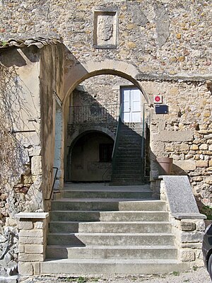
 Entrance to the priory |
||
Tulette is a French commune with 1,989 inhabitants (at January 1, 2017) in the Drome region, in the region of Auvergne Rhône-Alpes ; it belongs to the Arrondissement of Nyons and the Canton of Grignan .
geography
The place is located in the very south of the Rhône-Alpes region on the border with the Provence-Alpes-Côte d'Azur region and is traversed by the Eygues .
Neighboring municipalities of Tulette are Visan (Vaucluse) in the north, Saint-Maurice-sur-Eygues in the east, Buisson (Vaucluse) in the southeast, Saint-Roman-de-Malegarde (Vaucluse) in the south, Sainte-Cécile-les-Vignes (Vaucluse ) in the southwest, Suze-la-Rousse in the west and Bouchet in the northwest.
Population development
| year | 1962 | 1968 | 1975 | 1982 | 1990 | 1999 | 2009 | 2016 |
| Residents | 1,331 | 1,402 | 1,440 | 1,507 | 1,575 | 1,707 | 1.915 | 1,976 |
Viticulture
The municipality has a share in the Côtes du Rhône wine-growing region and is allowed to market its wines under the designation of origin Côtes du Rhône AOC and Côtes du Rhône Villages AOC .
Attractions
- Saint-Pierre church and adjoining priory to the south
- Renaissance façades and -staircases, including two as a monument historique classified
- Notre-Dame du Roure chapel (10th century)
- City wall (completed at the end of the 14th century)
- Ruins of the Saint-Léger chapel
- Gallo-Roman ruins
Personalities
- Giuliano della Rovere (1443–1513), Prior of Saint-Saturnin du Port, Prince de Tulette, Pope Julius II.
Partner municipality
- Bastogne (Belgium)
