Colon cell
|
Colon cell Colonzèla |
||
|---|---|---|
|
|
||
| region | Auvergne-Rhône-Alpes | |
| Department | Drôme | |
| Arrondissement | Nyons | |
| Canton | Grignan | |
| Community association | Enclave des Papes-Pays de Grignan | |
| Coordinates | 44 ° 24 ' N , 4 ° 54' E | |
| height | 132-204 m | |
| surface | 6.06 km 2 | |
| Residents | 549 (January 1, 2017) | |
| Population density | 91 inhabitants / km 2 | |
| Post Code | 26230 | |
| INSEE code | 26099 | |
 Saint-Pierre-ès-Liens church |
||
Colonzelle ( Occitan : Colonzèla ) is a southern French city and a municipality with 549 inhabitants (at January 1, 2017) in the department of Drôme in the region Auvergne Rhône-Alpes . The hamlet of Margerie also belongs to the community .
location
The place Colonzelle is on the river Lez in the hilly landscape in the southwest of the Drôme department at an altitude of approx. 170 m. The next largest city, Montélimar , is approx. 31 kilometers (driving distance) to the northwest.
Population development
| year | 1800 | 1851 | 1901 | 1954 | 1999 | 2017 |
|---|---|---|---|---|---|---|
| Residents | 386 | 574 | 501 | 232 | 432 | 549 |
The population decline in the first half of the 20th century is largely due to the loss of jobs as a result of the mechanization of agriculture . The population increase in recent decades, on the other hand, is related to the relative proximity to the cities of Montélimar and Orange and the significantly lower property prices in the countryside.
economy
The inhabitants of the place lived for centuries as a self-sufficiency from agriculture (agriculture and cattle breeding). Wine was also grown; the place still has the right to market its grapes through the Appellations Comtés Rhodaniens , Mediterranée , Grignan-les-Adhémar and Drôme ; There are still vineyards in the vicinity of the village, but there are no longer any vintners in the village. Since the last decades of the 20th century, tourism has played an important role in the economic life of the place in the form of renting holiday apartments ( gîtes ) .
history
Gallo-Roman traces have been discovered in the municipality. The existence of the modern town, however, is the foundation of Cluny - priory by Adhemar due in the 11th century. Colonzelle belonged to the barony since the 13th century , later to the county of Grignan. During the Huguenot Wars (1562-1598), but also in 1620, the place was sacked by Protestant troops.
Attractions
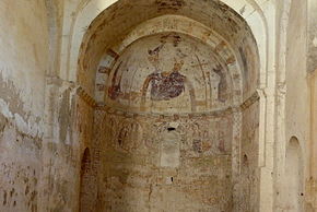
- The small late Romanesque priory church of Saint-Pierre-ès-Liens is located about one kilometer south of today's town. The unadorned building, made of roughly hewn quarry stone , but with an effort to ensure regular stone layers and stabilized by side buttresses , was later plastered. In contrast to the simple west portal of the church, the monk's gate on the south side - which was later walled up - shows simple decorative motifs and characters. Remains of late Gothic wall paintings from the 14th century were discovered inside the church . The building was recognized as a monument historique in 1926 .
- The parish church of Notre-Dame-des-Lumières is located in the hamlet of Margerie and is a neo-Romanesque building from the late 19th century, which, with the exception of the west tower, was also made of rubble and then plastered.
literature
- Serge Panarotto: Chapelles de Provence. Edition Edisud 2007, ISBN 978-2-7449-0817-0
Web links
Individual evidence
- ^ Colon cell - viticulture
- ^ Geneviève Jourdan: Les peintures murales de Saint-Pierre de Colonzelle: une découverte récente dans le canton de Grignan (Drôme). In: In Situ. Revue des patrimoines No. 2, 2002
- ↑ Église Saint-Pierre-ès-Liens, Colon cell in the Base Mérimée of the French Ministry of Culture (French)
- ↑ Chapelles de Provences - photos + information

