
Lachau
| Lachau | ||
|---|---|---|
|
||
| region | Auvergne-Rhône-Alpes | |
| Department | Drôme | |
| Arrondissement | Nyons | |
| Canton | Nyons et Baronnies | |
| Community association | Sisteronais-Buëch | |
| Coordinates | 44 ° 14 ' N , 5 ° 38' E | |
| height | 676-1,538 m | |
| surface | 25.78 km 2 | |
| Residents | 232 (January 1, 2017) | |
| Population density | 9 inhabitants / km 2 | |
| Post Code | 26560 | |
| INSEE code | 26154 | |
 Local panorama |
||

Lachau is a French municipality with 232 inhabitants (at January 1, 2017) in the region of Auvergne Rhône-Alpes . It belongs to the Département Drôme , the Arrondissement Nyons and the Canton Nyons et Baronnies . It is bordered by Ballons to the north, Salérans to the northeast, Éourres to the east, Curel to the southeast, Montfroc to the southwest and Eygalayes to the west .
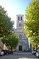
Notre-Dame-de-l'Assomption church

Notre-Dame-de-Calma church


Population development
| year | 1962 | 1968 | 1975 | 1982 | 1990 | 1999 | 2008 | 2016 |
|---|---|---|---|---|---|---|---|---|
| Residents | 217 | 217 | 225 | 234 | 190 | 225 | 206 | 228 |
Web links
Commons : Lachau - Collection of images, videos and audio files