Charols
| Charols | ||
|---|---|---|

|
|
|
| region | Auvergne-Rhône-Alpes | |
| Department | Drôme | |
| Arrondissement | Nyons | |
| Canton | Dieulefit | |
| Community association | Montélimar agglomeration | |
| Coordinates | 44 ° 36 ′ N , 4 ° 57 ′ E | |
| height | 71-395 m | |
| surface | 7.31 km 2 | |
| Residents | 918 (January 1, 2017) | |
| Population density | 126 inhabitants / km 2 | |
| Post Code | 26450 | |
| INSEE code | 26078 | |
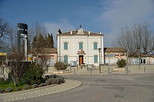
 City Hall (Mairie) of Charols |
||
Charols is a French municipality with 918 inhabitants (at January 1, 2017) in the department of Drôme in the region Auvergne Rhône-Alpes (before 2016 Rhône-Alpes ); it belongs to the Arrondissement of Nyons and the canton of Dieulefit (until 2015 Marsanne ). The inhabitants are called Charolais .
geography
Charols is located around 33 kilometers south-southeast of Valence on the Roubion . Charols is surrounded by the neighboring communities Cléon-d'Andran in the north and north-west, Puy-Saint-Martin in the north and north-east, Manas in the north-east, Pont-de-Barret in the east, Salettes in the south and La Bégude-de-Mazenc in the south and west.
Population development
| year | 1962 | 1968 | 1975 | 1982 | 1990 | 1999 | 2006 | 2013 |
| Residents | 278 | 265 | 261 | 305 | 415 | 501 | 693 | 841 |
| Source: Cassini and INSEE | ||||||||
Attractions
- Saint-Jean-Baptiste church from the 9th century, monument historique since 1994
- Bridge over the Roubion
- moth
Web links
Commons : Charols - collection of images, videos and audio files

