
Chantemerle-lès-Grignan
| Chantemerle-lès-Grignan | ||
|---|---|---|
|
||
| region | Auvergne-Rhône-Alpes | |
| Department | Drôme | |
| Arrondissement | Nyons | |
| Canton | Grignan | |
| Community association | Enclave des Papes-Pays de Grignan | |
| Coordinates | 44 ° 24 ′ N , 4 ° 50 ′ E | |
| height | 99-351 m | |
| surface | 9.82 km 2 | |
| Residents | 251 (January 1, 2017) | |
| Population density | 26 inhabitants / km 2 | |
| Post Code | 26230 | |
| INSEE code | 26073 | |
| Website | http://www.mairie-chantemerlelesgrignan.fr/ | |
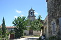
 Town hall (Mairie) of Chantemerle-lès-Grignan |
||

Chantemerle-lès-Grignan is a French municipality with 251 inhabitants (as of January 1 2017) in the Drome region, in the region of Auvergne Rhône-Alpes ; it belongs to the Arrondissement of Nyons and the Canton of Grignan .
geography
Chantemerle-lès-Grignan is located about 70 kilometers south-southwest of Valence . Neighboring municipalities of Chantemerle-lès-Grignan are Réauville in the north, Grignan in the east and northeast, Chamaret in the east, Montségur-sur-Lauzon in the south and southeast, Clansayes in the south and southwest and Valaurie in the west and northwest.
Population development
| year | 1962 | 1968 | 1975 | 1982 | 1990 | 1999 | 2006 | 2013 |
|---|---|---|---|---|---|---|---|---|
| Residents | 130 | 115 | 94 | 114 | 180 | 177 | 214 | 251 |
| Source: Cassini and INSEE | ||||||||
Attractions
- Saint-Maurice church from the 18th century
- Notre-Dame-des-Grâces chapel from the 14th century
- medieval remains
Saint-Maurice Church

Notre-Dame-des-Grâces chapel


Web links
Commons : Chantemerle-lès-Grignan - Collection of images, videos and audio files