Propiac
| Propiac | ||
|---|---|---|
|
|
||
| region | Auvergne-Rhône-Alpes | |
| Department | Drôme | |
| Arrondissement | Nyons | |
| Canton | Nyons et Baronnies | |
| Community association | Baronnies en Drôme Provençale | |
| Coordinates | 44 ° 17 ′ N , 5 ° 12 ′ E | |
| height | 297-782 m | |
| surface | 11.15 km 2 | |
| Residents | 131 (January 1, 2017) | |
| Population density | 12 inhabitants / km 2 | |
| Post Code | 26170 | |
| INSEE code | 26256 | |
| Website | www.propiac.com | |
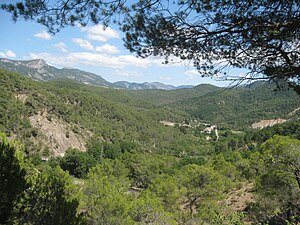
 Valley with Propiac (center) |
||
Propiac , also called Propiac-les-Bains in tourist guides , is a French commune with 131 inhabitants (January 1, 2017) in the Drôme department in the Auvergne-Rhône-Alpes region . It belongs to the Arrondissement of Nyons and the Canton of Nyons et Baronnies . embossed.
Propiac is located at 367 m above sea level on the pass road to Col de Propiac , which leads from Buis-les-Baronnies via Faucon to Vaison-la-Romaine . The municipality is located eight kilometers west of Buis-les-Baronnies, 14 kilometers east of Vaison-la-Romaine and 22 kilometers south of Nyons .
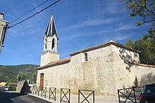
From Propiac the visitor has a good view of Mont Ventoux , which towers over all the surrounding mountains at 1912 meters. The town's landmark is the Saint-Marcel church. The community is designated as a health resort . Viticulture also plays an important role.
The D147 runs through Propiac and crosses the Col de Propiac. Immediately at the end of the village, the D347 joins the D147 from the south. At the beginning of the 20th century Propiac shared a station on the Orange-Buis-les-Baronnies railway line with Mollans-sur-Ouvèze, ten kilometers away .
Population development
| year | 1962 | 1968 | 1975 | 1982 | 1990 | 1999 | 2006 | 2016 |
| Residents | 44 | 38 | 49 | 47 | 60 | 78 | 105 | 124 |
| Sources: Cassini and INSEE | ||||||||

