Bouvières
| Bouvières | ||
|---|---|---|
|
|
||
| region | Auvergne-Rhône-Alpes | |
| Department | Drôme | |
| Arrondissement | Nyons | |
| Canton | Dieulefit | |
| Community association | Dieulefit-Bourdeaux | |
| Coordinates | 44 ° 31 ' N , 5 ° 13' E | |
| height | 540-1,577 m | |
| surface | 25.05 km 2 | |
| Residents | 146 (January 1, 2017) | |
| Population density | 6 inhabitants / km 2 | |
| Post Code | 26460 | |
| INSEE code | 26060 | |
Bouvières is a french commune in the department of Drôme in the region Auvergne Rhône-Alpes .
geography
Bouvières is about seven kilometers east of Montélimar (as the crow flies). The municipality has a size of 25.05 km² and mainly comprises agricultural land and forest areas. The Roubion river crosses the territory of the commune of Bouvières.
Population development
With 146 inhabitants (as of January 1, 2017), the municipality of Bouvières is one of the smaller municipalities in the Drôme department. In 1968 Bouvières still had 196 inhabitants, since then the number of inhabitants has steadily decreased.
| year | 1962 | 1968 | 1975 | 1982 | 1990 | 1999 | 2007 | 2016 |
| Residents | 209 | 196 | 194 | 181 | 184 | 160 | 153 | 147 |
| Sources: Cassini and INSEE | ||||||||

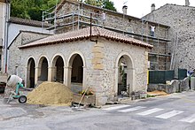
Lavoir in Bouvières
|
Web links
Commons : Bouvières - Collection of images, videos and audio files

