Rochegude (Drôme)
| Rochegude | ||
|---|---|---|

|
|
|
| region | Auvergne-Rhône-Alpes | |
| Department | Drôme | |
| Arrondissement | Nyons | |
| Canton | Le Tricastin | |
| Community association | Drôme Sud Provence | |
| Coordinates | 44 ° 15 ′ N , 4 ° 50 ′ E | |
| height | 101-365 m | |
| surface | 18.3 km 2 | |
| Residents | 1,579 (January 1, 2017) | |
| Population density | 86 inhabitants / km 2 | |
| Post Code | 26790 | |
| INSEE code | 26275 | |
| Website | www.mairie-rochegude.fr | |
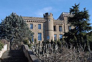
 Château de Rochegude |
||
Rochegude is a French commune with 1,579 inhabitants (at January 1, 2017) in the department of Drôme in the region Auvergne Rhône-Alpes .
geography
Rochegude is about ten kilometers east of the Rhône and the parallel A7 autoroute . Larger towns in the area are Saint-Paul-Trois-Châteaux in the north and Orange in the south. The next big city is Avignon , 40 kilometers south. The neighboring municipalities are Suze-la-Rousse in the north, Sainte-Cécile-les-Vignes in the east, Lagarde-Paréol in the south-east, Uchaux in the south-west, Mondragon in the west and Bollène in the north-west.
Population development
| year | 1962 | 1968 | 1975 | 1982 | 1990 | 1999 | 2005 | 2016 |
| Residents | 601 | 591 | 684 | 831 | 1053 | 1236 | 1346 | 1586 |
| Sources: Cassini and INSEE | ||||||||
Attractions
- In the north of the village, on the D8 in the direction of Bollène, there are the ruins of a fortified church called Notre-Dame-des-Aubagnans , Monument historique since 1926
- Chapel of Saint Denis the 12th century
- The castle was completely restored by the Marquis de Rochegude and converted into a luxury hotel
economy
The local winemakers produce wines from the Côtes du Rhône Villages appellation .
Web links
Commons : Rochegude - collection of images, videos and audio files
