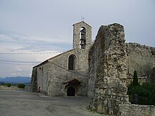
Sauzet (Drôme)
| Sauzet | ||
|---|---|---|

|
|
|
| region | Auvergne-Rhône-Alpes | |
| Department | Drôme | |
| Arrondissement | Nyons | |
| Canton | Dieulefit | |
| Community association | Montélimar agglomeration | |
| Coordinates | 44 ° 36 ′ N , 4 ° 49 ′ E | |
| height | 92-430 m | |
| surface | 19.19 km 2 | |
| Residents | 1,840 (January 1, 2017) | |
| Population density | 96 inhabitants / km 2 | |
| Post Code | 26740 | |
| INSEE code | 26338 | |
| Website | http://www.sauzet-drome.fr/index.php | |
Sauzet is a commune with 1,840 inhabitants (as of January 1 2017) in the department of Drôme in the region Auvergne Rhône-Alpes . It belongs to the Arrondissement of Nyons and the Canton of Dieulefit (until 2015: Canton Marsanne ). Sauzet is a member of the Montélimar-Agglomération municipal association .
geography
Sauzet is located in the metropolitan area around seven kilometers northeast of Montélimar on the Roubion River . Sauzet is surrounded by the neighboring communities of Condillac in the north, La Laupie in the northeast, Bonlieu-sur-Roubion in the east, La Bâtie-Rolland in the southeast, Montboucher-sur-Jarbon in the south, Montélimar in the southwest, Savasse in the west and northwest and Saint- Marcel-lès-Sauzet in the northwest.
The A7 autoroute runs through the municipality .
Population development
| year | 1962 | 1968 | 1975 | 1982 | 1990 | 1999 | 2006 | 2012 |
| Residents | 967 | 1.110 | 1,126 | 1,335 | 1,436 | 1,673 | 1,860 | 1,843 |
| Source: Cassini and INSEE | ||||||||
Attractions
- Saint-Lambert Church
- Castle complex
- several fortified houses with modifications from the 16th to 20th centuries
- 19th century Villa Sestier
Parish partnership
There is a partnership with the French community of Sauzet in the Gard (Languedoc-Roussillon) department.

