Chamaret
| Chamaret | ||
|---|---|---|
|
|
||
| region | Auvergne-Rhône-Alpes | |
| Department | Drôme | |
| Arrondissement | Nyons | |
| Canton | Grignan | |
| Community association | Enclave des Papes-Pays de Grignan | |
| Coordinates | 44 ° 24 ' N , 4 ° 53' E | |
| height | 135-264 m | |
| surface | 7.79 km 2 | |
| Residents | 546 (January 1, 2017) | |
| Population density | 70 inhabitants / km 2 | |
| Post Code | 26230 | |
| INSEE code | 26070 | |
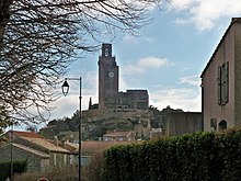
Chamaret is a French commune in the department of Drôme in the region Auvergne Rhône-Alpes . The inhabitants call themselves Chamarétois. The view of the medieval city is dominated by a fortress with two mountain tombs visible from afar .
geography
Chamaret is about nine kilometers from Valréas and in the immediate vicinity of Colonzelle .
Population development
| year | 1962 | 1968 | 1975 | 1982 | 1990 | 1999 | 2007 | 2016 |
| Residents | 347 | 312 | 275 | 349 | 455 | 493 | 538 | 561 |
| Sources: Cassini and INSEE | ||||||||
With 546 inhabitants (as of January 1, 2017), Chamaret is one of the smaller communities in the Drôme department.
Attractions
- Tower and the ruins of the castle
- Saint Barthélemy Church
Web links
Commons : Chamaret - collection of images, videos and audio files

