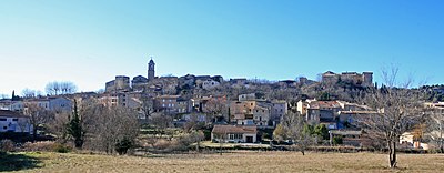
Mormoiron
| Mormoiron | ||
|---|---|---|

|
|
|
| region | Provence-Alpes-Cote d'Azur | |
| Department | Vaucluse | |
| Arrondissement | Carpentras | |
| Canton | Pernes-les-Fontaines | |
| Community association | Ventoux Sud | |
| Coordinates | 44 ° 4 ′ N , 5 ° 11 ′ E | |
| height | 179-450 m | |
| surface | 25.03 km 2 | |
| Residents | 1,873 (January 1, 2017) | |
| Population density | 75 inhabitants / km 2 | |
| Post Code | 84570 | |
| INSEE code | 84082 | |
 Bell tower of the Church of Mormoiron |
||
Mormoiron is a French commune with 1,873 inhabitants (at January 1, 2017) in the department of Vaucluse in the region Provence-Alpes-Cote d'Azur .
geography
Mormoiron is located in the Vaucluse department between the municipalities of Bédoin , Villes-sur-Auzon and Mazan at an altitude of about 280 meters. The Ruisseau de Saint-Laurent stream flows through the village and flows into the Auzon .
Population development
| year | 1793 | 1856 | 1896 | 1926 | 1954 | 1962 | 1968 | 1975 | 1982 | 1990 | 1999 | 2006 |
|---|---|---|---|---|---|---|---|---|---|---|---|---|
| Residents | 1,617 | 2,579 | 1,387 | 963 | 922 | 956 | 997 | 1,018 | 1,070 | 1,264 | 1,562 | 1,785 |
Sources: INSEE and Cassini
economy
Mormoiron is part of the Côtes du Ventoux wine-growing region . Together with the neighboring village of Villes-sur-Auzon, the grapes are pressed, expanded and sold through a cooperative.
Culture
The theme of the museum is the mining and processing of local mineral resources ( gypsum , ocher and clay ). It also has a small but interesting prehistoric and paleontological collection, including the full skeleton of a palaeotherium (fossil mammal).
See also
Individual evidence
- ^ Mormoiron in Cassini
- ↑ Michel Albarède et al .: Vaucluse (= Encyclopédies du Voyage ). Gallimard Loisirs, Paris 2007, ISBN 2-7424-1900-4 , p. 326 .
- ↑ Le Musée. mormoiron.com, accessed April 28, 2020 (French).
Web links
- Community presentation (French)

