Easter tree
|
Ostersbaum (02) district of Wuppertal |
|
|---|---|
| Coordinates | 51 ° 15 '54 " N , 7 ° 9' 21" E |
| height | 150- 200 m above sea level. NHN |
| surface | 1.38 km² |
| Residents | 15,731 (December 31, 2018) |
| Population density | 11,399 inhabitants / km² |
| Proportion of foreigners | 30.7% (Dec. 31, 2018) |
| Post Code | 42107 |
| prefix | 0202 |
| Borough | Elberfeld |
| Transport links | |
| Highway |
|
| bus | 607 612 622 623 625 635 643 645 CE65 NE4 |
| Source: 2018 Wuppertal Statistics - spatial data | |
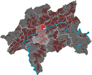
The Ostersbaum residential area in Wuppertal is one of six districts in the Elberfeld district .
geography
The 1.38 km² residential area is bordered in the north by the federal highway 46 , in the east by the streets Schwesterstraße and Schwabenweg , in the south by the street Hofkamp and in the west by the street Gathe and its continuation Uellendahler Straße . Clockwise, the Uellendahl-West , Clausen , Loh , Elberfeld-Mitte and Nordstadt residential areas surround the Ostersbaum residential area.
Except for the Ostersbaum part of the park on the Hardtberg, the residential area is densely built up and belongs to the inner city area. The central point is the Republic Square on the Engelnberg . Sights include the botanical garden , an open-air stage and the Elisenturm on the Hardt and the old Jewish cemetery on Weißenburgstrasse . The infrastructure includes three primary schools and one comprehensive school .
Etymology and history
The name Ostersbaum comes from a barrier on the Elberfeld line of the Bergische Landwehr that runs through today's residential area and was guarded by a Mostert family . The place name Am Mostertsbaum became Am Ostersbaum .
The population center of Ostersbaum is largely in the field of Barmen at today Rudolfstraße corner sister street . Only with the large-scale settlement of the area around Elberfelder Platz der Republik did the name of the location transfer to the Elberfeld area.
In 1815/16 the core of the settlement had 238 inhabitants. In 1832 the place belonged to Section 1 of the rural foreign citizenship of the city of Barmen . The place, which was categorized as individual houses according to the statistics and topography of the Düsseldorf administrative district , had 14 residential buildings and three agricultural buildings at that time. At that time there were 214 inhabitants in the place, 42 of the Catholic and 172 of the Protestant faith.
In 1879 the Wuppertal Northern Railway was opened, which was laid right through the center of the settlement and divided it into two parts.
Transport infrastructure
The disused railway line Düsseldorf-Derendorf-Dortmund Süd ( Wuppertaler Nordbahn ) crossed under the Engelnberg in the Engelnberg tunnel and had a stopping point established in 1952 under the name Wuppertal-Ostersbaum in the residential area . From here, commuters and schoolchildren could use the railcars for trips to other parts of the city. This was served until 1991.
Culture
Light trails
In 2009, the art campaign “Lights Paths” celebrated its tenth anniversary, and over 3000 colored lights were placed on the numerous stairs in the district. Numerous international choirs and musicians accompany the romantic light show. The campaign, which has become an integral part of the Wuppertal cultural calendar, is now threatened with end. Due to the city's debt situation, it is not allowed to further promote these and similar campaigns in the future. In 2004 the campaign won second prize in the image competition "Social City NRW",
Stair art
In Ostersbaum there are fifteen stairs, including the listed outside stairs Engelnbergtreppe and Holsteiner stairs . A partly poor condition of the stairs led to structural redesign from 1999 onwards. Osterbaum also took part in the 2006 Regionale with the art project “7 stairs”, in which stairs were artistically redesigned. The colored design of the Holstein staircase was permanently retained. In 2009, the art of stairs was awarded the National Prize for Integrated Urban Development and Building Culture by the Federal Ministry of Transport .
See also
- List of architectural monuments in the Ostersbaum residential area in Wuppertal (A – F)
- List of architectural monuments in the Ostersbaum residential area in Wuppertal (G – Z)
Individual evidence
- ↑ a b Johann Georg von Viebahn : Statistics and Topography of the Administrative District of Düsseldorf , 1836
- ^ André Joost: Operating Offices Archive Wuppertal-Ostersbaum. In: NRWbahnarchiv. Retrieved June 22, 2017 .
- ↑ New train stations on the REG line. In: Bahnen-Wuppertal.de. Retrieved June 22, 2017 .
- ^ "Paths of Lights" plus protest: Wuppertaler Rundschau from January 31, 2009
- ↑ Federal Ministry of Transport: SozialeStadt.de: staircase staging - Public stairs in the district Ostersbaum Accessed on 17 December 2011th
- ↑ StadtbauenStadtleben.de :. (No longer available online.) In: Results> Committed to the city. Formerly in the original ; accessed on September 13, 2018 . ( Page no longer available , search in web archives )


