
Schefflenz
| coat of arms | Germany map | |
|---|---|---|

|
Coordinates: 49 ° 24 ' N , 9 ° 17' E |
|
| Basic data | ||
| State : | Baden-Württemberg | |
| Administrative region : | Karlsruhe | |
| County : | Neckar-Odenwald district | |
| Height : | 273 m above sea level NHN | |
| Area : | 36.97 km 2 | |
| Residents: | 3922 (December 31, 2018) | |
| Population density : | 106 inhabitants per km 2 | |
| Postal code : | 74850 | |
| Area code : | 06293 | |
| License plate : | MOS, BCH | |
| Community key : | 08 2 25 115 | |
| LOCODE : | DE ZFW | |
| Community structure: | 4 districts | |
| Address of the municipal administration: |
Mittelstrasse 47 74850 Schefflenz |
|
| Website : | ||
| Mayor : | Rainer Houck ( CDU ) | |
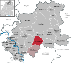
| Location of the community Schefflenz in the Neckar-Odenwald district | ||
  |
||

Schefflenz is a municipality in the Neckar-Odenwald district in Baden-Württemberg . It belongs to the European metropolitan region of Rhine-Neckar (until May 20, 2003 the Lower Neckar region and until December 31, 2005 the Rhine-Neckar-Odenwald region ).
geography
Geographical location
The four districts are located on the by the Bach Schefflenz eingetalten limestone plateau of the southwestern building land in 250-310 meters, the edge heights reach a maximum of approximately 350 m. In the far north of the municipal area, the Upper Röttonen rock formations of the Buntsandstein are already pending, which are characteristic of the neighboring landscape of the so-called Hinteren Odenwald in the northwest , but geomorphologically inconspicuous as a slightly sloping plane with the shell limestone evenness to a presumably tertiary (several million ago Years) unite the hull area in the direction of Heidersbach and Rittersbach . The municipality is partly in the Neckartal-Odenwald nature park .
geology
Depending on the geological subsoil, the deepening of the valley on the right of the Schefflenz (i.e. in the west) in the municipal area predominantly rises gently towards the watershed towards the Elz (mostly in the Middle Muschelkalk ). To the left of the valley (i.e. to the east) and in the Upper Muschelkalk, the Schefflenz has carved out a more striking valley layer from Kleineicholzheim to Oberschefflenz. Below Oberschefflenz, the layer level changes the valley side and on the north side of the Vogelberg (338 m above sea level) is only clearly visible again in the catchment area of the Elz, namely in the Auerbachtal. The stately 544 m long Vogelberg tunnel in Schefflenz connects the catchment areas of Neckar (Auerbachtal) and (Neckar-) Jagst (Schefflenztal) in the east of the Auerbachtal . In the 1860s (commissioning: Aug. 25, 1866) this route offered topographical and territorial advantages over a more northerly (Elztal) route, in order to guarantee a route within the Baden area until shortly before Würzburg . The height of the tunnel is slightly over 300 m.
The presence of very high-quality soils with climatic conditions that basically allowed viticulture (annual mean temperature in the 1980s and 90s consistently above 9 ° C) are typical conditions of an old settlement landscape (landscape of building land ). The soil quality results from the geological substrate (little karstified shell limestone) and moderate loess cover . However, there are some karst phenomena (waterless hollow forms) on the heights around (in the Weidachswald and southwest of Großeicholzheim ).
climate
Climatically, the lower topographical altitude compared to the neighboring Odenwald to the north is due to the higher temperature and lower but i. d. Usually sufficient amounts of precipitation (> 600 l / m² per year; i.e. precipitation greater than evaporation, no additional irrigation necessary for conventional crops) is noticeable. The relatively open location of the valley and plateaus with a general south-south-west orientation, which is advantageous in terms of radiation technology, is also "useful" from an agricultural / climatic point of view. The seasonal temperature curve mostly shows maxima in late July and early August, several lows usually occur from the beginning of December to mid-February (according to our own measurements 1987–1996 and historical evaluations as far back as the 1920s). In the thermal extremes, which are sometimes delayed compared to the position of the sun, and in the winter maximum of precipitation (especially December), properties of a more oceanic dominated suboceanic to subcontinental transitional climate come into their own. It can be assumed that the heights of the Odenwald to the north and north-west (up to approx. 600 m above sea level) may have a shielding effect in terms of precipitation or a slight damming effect. a. With westerly to northerly winds, a slight warming blow-dryer effect is to be expected (not proven in figures). Short-term fluctuations in circulation and weather conditions, as in many places in the middle latitudes , occasionally lead to notable, "historical" events that are reflected in the general memory of the locals - usually classified according to the seasons. B .:
- lowest (lowest) temperature: approx. −30 ° C, probably winter 1928/29;
- Depth of snow over 50 cm: March 1987, December 2001;
- brook frozen over for the last time: end of the 1960s;
- regional “century” floods: December 1993;
- Storm events: late winter 1990, Christmas storm Lothar 1999.
Evidence for these and (not listed) other extreme events are based on information from contemporary witnesses as well as on personal and / or official documentation.
Settlement and population geography
In terms of settlement geography, Unter- and Mittelschefflenz belong to the clustered village type. The course of the road appears to be random, the arrangement of the farmsteads arbitrary. In contrast, the historical local setters of Oberschefflenz are concentrated along the main street (approx. 120 building units) and along a few side streets (approx. 60 building units). The course of the old Heidelberg-Würzburg trade and military route is traced along the Oberschefflenzer Hauptstrasse. The Römerweg (from the 1st century AD) also led to the east through the Schefflenz Valley. However, the exact course is controversial: While Roedder assumes an early tour over the heights south of the Elz Valley through Oberschefflenz, Ebersold advocates an old Mittel / -Unterschefflenz route. In any case, the Roman road crossed the only valley on the route between the Roman camps Neckarburken (West) and Osterburken (East) for 30 km in what is now the municipality. In Kleineicholzheim, the so-called "hamlet", the features of a cluster and a street village are mixed, whereas on Odenwaldstrasse and Seckacher Strasse - the two main routes - as in Oberschefflenz, unregulated forms of street or row villages predominate.
The Schefflenzdörfer and Kleineicholzheim are four (territorially) historically closely related units. Nonetheless, over the centuries there has only been an administrative merging of today's districts, only and ultimately in the course of the municipal reform of the early 1970s, even if the naming of the three Schefflenzdörfer “always” shows old ties. This bond was evident over the centuries in the mixed claims of the Electoral Palatinate and Kurmainz on the villages. In 1973, on the other hand, the political community affiliations of the two Eicholzheimdörfer changed after referendums: Groß- im Obersten Schefflenztal to the community of Seckach, Klein- zu Schefflenz.
It should be noted that after the end of the Second World War, Schefflenz experienced a considerable increase in population as a result of the expulsion of the population, classified as German - essentially linguistically and in historical memory - from Central and Eastern European settlement areas (above all Sudetenland, Moravia, Hungary; also Danzig) after the end of the Second World War. To this day, private peculiarities of the local war refugees in the care of dialect or religion or cultural self-image, e.g. Partly away, but not as a club (as in the district town of Mosbach ). From a denominational point of view, the influx of war refugees has resulted in an increase in the Catholic population compared to the traditional Calvinist-Protestant majority.
In terms of population structure, the outskirts of the municipality between the metropolitan areas of Heidelberg-Mannheim, Heilbronn / Neckar-Unterland as well as Rhine-Main and Würzburg have been noticeable in the last two decades through an overall stagnating population. Migration, births and deaths resulted in a maximum population of around 4400 people in 1995 and 2000, while a slight decrease has continued since then (4290 inhabitants at the end of 2005). Compared to the national average of 220, the population density is below average with slightly less than 120 inhabitants / km². In contrast, the mean ages of the male and female population groups are pretty much the same as in Baden-Württemberg in 2005: 40.0 years for men (B.-W .: 40.1), 43.0 for women (B.-W .: 42, 7). [State Statistical Office B.-W., see web links]
Community structure
The municipality of Schefflenz consists of the four districts of Kleineicholzheim (228 inhabitants, 2017), Mittelschefflenz (1070 inhabitants), Oberschefflenz (1505 inhabitants) and Unterschefflenz (1146 inhabitants). The districts are identical in area to the earlier communities of the same name.
The village of Kleineicholzheim and the village of Eicholzheim train station belong to the Kleineicholzheim district. Only the villages of the same name belong to the districts of Mittelschefflenz and Oberschefflenz. The village of Unterschefflenz, the village of Am Kelchenwald and the house Kelchenmühle belong to the district of Unterschefflenz.
The Eildorf desert is located in the Mittelschefflenz district .
Neighboring communities
The following communities border on the community of Schefflenz. They partly belong to the Neckar-Odenwald district and partly to the Heilbronn district : Adelsheim , Billigheim , Elztal , Limbach , Roigheim (Heilbronn district) and Seckach .
history
Schefflenz is first mentioned in the Lorsch Codex on the occasion of a donation by a Lentrich in 774 as Scaflenze . As imperial villages , the three Schefflenzdörfer initially had imperial immediacy. In the course of the Middle Ages, however, various knight families acquired rights to the villages. After the dissolution of the Lorsch monastery in 1232, the three villages came to Kurmainz . From the second half of the 14th century the Electoral Palatinate tried to gain dominance in the area, which gradually succeeded in Schefflenz. In 1545, the Reformation was introduced in the Electoral Palatinate according to the Lutheran confession. This exacerbated the conflict between Kurpfalz and Kurmainz. In 1653 Kurmainz renounced all rights to the three Schefflenzdörfern and Schefflenz finally came to the Electoral Palatinate.
After the Thirty Years War , the population grew strongly, also due to immigration. When the Electoral Palatinate was dissolved in the Reichsdeputationshauptschluss 1803, Schefflenz first came to the Principality of Leiningen and from 1806 to the Grand Duchy of Baden . In the middle of the 19th century, around 500 residents left Schefflenz, mostly for North America. In 1862 Oberschefflenz was connected to the Heidelberg – Würzburg railway line . During the Nazi era , eight Jewish residents became victims of the Shoah . A plaque commemorates her in the Jewish cemetery in Bödigheim , her traditional burial place.
On January 1, 1972, the community of Schefflenz was formed by merging the previously independent communities of Mittelschefflenz, Oberschefflenz and Unterschefflenz. On February 1, 1972, the community of Kleineicholzheim was incorporated into Schefflenz.
Coats of arms of the former municipalities

Mittelschefflenz

Oberschefflenz

Underefficiency

Kleineicholzheim


politics
Municipal council
The municipal council has 14 honorary members who are elected for five years. In addition, the mayor acts as the municipal council chairman with voting rights.
The 2019 local elections led to the following result (in brackets: difference to 2014):
| Municipal Council 2019 | ||||
|---|---|---|---|---|
| Party / list | Share of votes | Seats | ||
| Nomination 2 | 54.0% (+7.7) | 8 (+2) | ||
| Nomination 1 | 46.0% (−7.7) | 6 (−2) | ||
| Turnout: 65.7% (+8.5) | ||||
mayor
At the head of the community is the mayor, who is directly elected by the population for eight years. His deputies are newly elected by the municipal council after the municipal council elections. In the election on October 12, 2008, Rainer Houck won the election as mayor with 57.1 percent. He replaces Peter Fox (CDU), who served for 16 years.
- 1972–1992: Hermann Döttling (Free Voters)
- 1992-2008: Peter Fox (CDU)
- since November 28, 2008: Rainer Houck (CDU), Houck was confirmed in office in September 2016 with 71.2% of the votes.
coat of arms
By a curved silver (white) tip, in which a green oak leaf lying to the left under a green pea pod placed in a pile with silver (white) peas, split; in front of blue and silver (white) roughened obliquely to the left (Wittelsbach coat of arms: the Electoral Palatinate as part of the Wittelsbach heritage), behind in black a red armored and red-tongued golden (yellow) lion.
Community partnerships
Schefflenz maintains community partnerships with the following communities:
Culture and sights
Buildings
There is a Protestant church in Unterschefflenz, the portal of which is dated 1764. In front of the church there is a dancing linden tree planted in 1870 , and in the adjacent cemetery there are two war memorials for those who died in the town from the wars of 1870/71 and 1914 to 1918 and 1939 to 1945. The citizens' office is a modern, functional building from 1957/58 . The town's schoolhouse, built in 1911, now serves as a residential building. As in the other districts, there are numerous historical half-timbered buildings in Unterschefflenz, including the building from 1797, which is now used as a local museum.

former town hall

Local museum

Evang. church

War memorials


In Mittelschefflenz there is a Protestant church, which was completed in its current form in 1473 and has been extensively renovated in recent years. On the long wall of the nave is a sundial, in front of the church there is a war memorial. The town hall is also a modern, functional building.

Evang. church
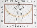
Sundial at Protestant church

old town hall replaced by a new building


In the center of Oberschefflenz there is the Catholic Church of St. Kilian from 1795 and the Protestant church built in 1885 in the neo-Gothic style. The schoolhouse was built in 1909.

Catholic Church of St. Kilian

Evang. church

school

S-Bahn station


The former castle of the Counts of Waldkirch is located in Kleineicholzheim, which also housed the synagogue of the local Jewish community from 1845 to 1938. The building was converted into an apartment building in the 1950s.
theatre
Every year at the beginning of the year, the theater group of the Eintracht Mittelschefflenz singing group takes place in the Schefflenzer Harmonie.
Museums
Local history museum of the Schefflenztal Collections e. V. in Unterschefflenz, which was awarded a home award.
Regular events
- Concerts by the Oberschefflenz Musikverein
- Concerts by the Schefflenz Music Corps
- Maypole erection of the trade association
- Oven festival of the association of the "Schefflenztal Collections e. V. "
- Everyone's shooting of the Schefflenz archery club
- Motocross races on the MSC Schefflenz World Championship course
Economy and Infrastructure
In addition to agriculture , medium-sized businesses (small agricultural engines, wood, paints) developed in the middle of the 20th century. Campina AG produces layered cheese and cream cheese in a dairy in Unterschefflenz . Craft businesses predominate locally. Some of the residents commute to Heilbronn or Neckarsulm and Mannheim to the industrial companies there .
traffic

The next motorways are the A 81 (Heilbronn - Würzburg, junction Osterburken, approx. 16 km, and Möckmühl, approx. 19 km) and the A 6 (Mannheim - Heilbronn, junction Sinsheim, approx. 50 km). The federal road 292 , which also serves as a feeder to the aforementioned motorway connections, runs through the municipality and the Oberschefflenz district .
With the RheinNeckar S-Bahn along the Neckarelz – Osterburken line , Schefflenz is well connected to Mannheim and Würzburg . With the S1 line, the Oberschefflenz and Eicholzheim stops are served every hour in the direction of Mosbach and Osterburken . From Osterburken there is a connection to Würzburg. In the direction of Mosbach, the S1 continues via Heidelberg and Mannheim directly to Kaiserslautern or Homburg . From 1908 to 1965, the private Schefflenz Valley Railway to Billigheim had its starting point in Oberschefflenz .
The local public transport ( ÖPNV ) also serve several bus routes.
media
The predominant daily newspaper in Schefflenz - especially as a subscription sheet - is the Mosbacher edition of the Rhein-Neckar-Zeitung published in Heidelberg . In its regional section it offers news from the Altkreis Mosbach .
The Schefflenzer Bote , which is published as a communal newsletter by Nussbaum Medien in Bad Rappenau , contains official announcements, current information from the municipal administration, school and church messages, reports from associations and parties as well as advertising content and private advertisements. The publisher is the municipality of Schefflenz. It is available as a print subscription, the "Schefflenz aktuell" section is available online on the Schefflenz community website.
Educational institutions
Schefflenz has a general education primary school in Oberschefflenz as well as a primary and secondary school with a Werkrealschule (Schefflenzschule). The educational offer is supplemented by offers from the Mosbach Music School and the Mosbach Adult Education Center . Musical instruments can also be learned in various clubs.
tourism
Forest parking lots, rest areas and shelters invite you to visit, as well as well-kept restaurants in the districts and in the surrounding area. The barefoot path at the top of the forest in the Mittelschefflenz district offers an alternative intermediate program .
leisure
Motocross area, outdoor pool in the Unterschefflenz district, well-developed bike paths, marked hiking trails, forest paths, forest hut with barbecue facilities, children's playgrounds, sports fields, sports halls, archery range, riding facility with hall.
Public facilities
- An old people's and nursing home of the DRK "Haus Luise von Baden" (new building 2006, former Roedderheim)
Personalities
Honorary citizen
The community of Schefflenz and the communities that are now part of Schefflenz have granted the following people honorary citizenship:
- 1930: Edwin Roedder (born April 8, 1873 in Hornberg-Niederwasser, † October 21, 1945 in Madison / Wisconsin), philologist
Sons and daughters of the church
- Augusta Bender (1846–1924), farmer's daughter, telegraph operator, teacher, women's rights activist, (native) writer, who struggled to realize her lifelong dream of going into the big wide world.
- Oskar Wirth (1884–1956), politician (BCSV, CDU), member of the Advisory State Assembly of the State of Baden.
- Ferdinand Strobel (1908–1999), Swiss Jesuit and church historian
- Otto Konrad (1924–1970), painter and graphic artist
- Ingolf Burkhardt (* 1963), jazz musician
literature
- Michael Böhm, Mayor's Office Schefflenz (ed.): Our expellees - the expulsion of the Germans from their settlement areas in southern and southeastern Europe .
- Günther Ebersold: In the forest there are the robbers - history and stories from the Odenwald and building land . Volk publishing house, Buchen 1990.
- Georg Fischer (Ed.): Augusta Bender - Collected Works . Odenwälder printing company, Buchen-Walldürn 1996.
- Franz Sales Meszmer: Historical Atlas of the Mosbach Region . History and Museum Association, Mosbach 1989.
- Günter Olbert: Valley development and layer level morphogenesis on the southern edge of the Odenwald . Tübingen geographic studies (64), Geographical Institute of the University of Tübingen, Tübingen 1975.
- Edwin Roedder: Folk language and vocabulary of the Baden Franconian region - represented on the basis of the dialect of Oberschefflenz . Modern Language Association of America, New York 1936.
- Edwin Roedder: The Southwest German Reichsdorf in the past and present - depicted on the basis of the history of Oberschefflenz in the Baden building land . Publishing house Schauenburg, Lahr 1928.
- Ernst Schmidt: Geomorphological studies in the rear Odenwald and in building land . Self-published by the Federal Institute for Regional Studies, Remagen 1954.
- Karl Otto Walter and Ludwig Sommer: Houses and people from Oberschefflenz - A walk through the village . Odenwälder printing company, Buchen-Walldürn 1998.
Web links
- Schefflenz community , homepage
- LEO-BW, discover regional studies online , Schefflenz
Individual evidence
- ↑ State Statistical Office Baden-Württemberg - Population by nationality and gender on December 31, 2018 (CSV file) ( help on this ).
- ↑ Günter Olbert: talent development and Schichtstufenmorphogenese on the southern edge of the Odenwald . Tübingen geographic studies (64), Geographical Institute of the University of Tübingen, Tübingen 1975
- ↑ Schefflenz - Short portrait on the Schefflenz website, accessed on March 26, 2017
- ↑ Main statute of the community of Schefflenz from September 21, 2009
- ^ The state of Baden-Württemberg. Official description by district and municipality. Volume V: Karlsruhe District Kohlhammer, Stuttgart 1976, ISBN 3-17-002542-2 . Pp. 322-324
- ↑ Minst, Karl Josef [transl.]: Lorscher Codex (Volume 5), Document 3580, August 24, 774 - Reg. 1072. In: Heidelberger historical stocks - digital. Heidelberg University Library, p. 220 , accessed on December 9, 2017 .
- ↑ Erhard Nietzschmann: The free in the country. Former German imperial villages and their coats of arms. Melchior, Wolfenbüttel 2013, ISBN 978-3-944289-16-8 , p. 58.
- ^ Website Schefflenz , history
- ↑ Memorial sites for the victims of National Socialism. A documentation, Volume I, Bonn 1995, p. 20, ISBN 3-89331-208-0
- ^ Federal Statistical Office (ed.): Historical municipality directory for the Federal Republic of Germany. Name, border and key number changes in municipalities, counties and administrative districts from May 27, 1970 to December 31, 1982 . W. Kohlhammer, Stuttgart / Mainz 1983, ISBN 3-17-003263-1 , p. 477 .
- ↑ State Statistical Office of Baden-Württemberg: Municipal elections 2019, Schefflenz ; Municipality of Schefflenz: municipal council election 2019 (PDF) ; Rhein-Neckar-Zeitung , May 27, 2019: This is the new local council of Schefflenz ; accessed July 2, 2019.
- ↑ http://www.rnz.de/nachrichten/mosbach_artikel,-Mosbach-Buergermeisterwahl-Schefflenz-Rainer-Houck-deutlich-im-Amt-bestaetigt-_arid,222606.html

Adelsheim | Aglasterhausen | Cheap home | Binau | Book | Elztal | Fahrbach | Hardheim | Hassmersheim | Höpfingen | Hüffenhardt | Limbach | Mosbach | Mudau | Neckargerach | Neckarzimmern | Neunkirchen | Obrigheim | Osterburken | Ravenstein | Rosenberg | Schefflenz | Schwarzach | Seckach | Waldbrunn | Walldürn | Zwingenberg