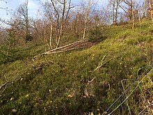
Niederwald Recklinghausen nature reserve
The Niederwald Recklinghausen nature reserve with a size of 25.1 hectares is located east of Recklinghausen in the urban area of Sundern (Sauerland) . The area was designated as a nature reserve (NSG) with an area of 25 hectares for the first time in 1993 with the Sundern landscape plan by the district council of the Hochsauerlandkreis . When the landscape planner Sundern was reorganized, the NSG was again identified and enlarged.
description
The NSG borders directly to the west on the buildings of Recklinghausen and Sundern-Oberröhre. In the south the landscape protection area borders the outskirts of Recklinghausen and in the north and east the landscape protection area Sundern .
The NSG is a coppice forest . The landscape plan Sundern explains to NSG: “The oak coppice rich in dwarf shrubs grows on a south exposed slope and the narrow ridge of a ridge north of Recklinghausen. The typical, multi-stemmed growth method is still widespread. The main tree species are, besides the sessile oak, birch and small areas of beech. The undergrowth is formed by a layer of herbs that partially covers the ground and is rich in bilberry and common heather. In the west of the area, rock cliffs up to 5 m high, but largely flatter, emerge, which merge into natural scree slopes down the slope. Individual specimens of other tree species such as ash and elm are mixed in at these locations, which indicate very weak transitions to the rubble forest. In these areas, the beech is represented in the multi-stemmed, low-forest type of growth. A high voltage line crosses the area in the eastern part. Spruce trees were planted on the route, some of which are interspersed with birch trees and heather. A noticeable amount of lichen in places is high on the trees. There are still numerous, mostly well-developed coppice forest areas in the planning area. As relics of a historical form of forest management, they represent evidence of the cultural landscape of this area. The present area occupies a special position within a network of coppice forest. "
Protection purpose
The landscape plan states: “Protection of a valuable forest (management) type, in places with rocky cliffs and natural rubble heaps and with a predominantly species-rich herb layer from a geological, faunistic, vegetation and cultural-historical point of view; Protection of a species-rich cryptogam flora; Preservation and optimization of a species-rich coppice forest area on a rocky-stony site in places through management adapted to the type of forest. The NSG also serves to sustainably secure the occurrence of rare animal and plant species. ”As with all nature reserves in Germany, the protection designation pointed out that the area became a nature reserve“ because of the rarity, special character and beauty of the area ”.
Development measure
In the landscape plan, the following additional development measures were stipulated: “Existing softwood must be removed (§ 13 LNatSchG); In order to maintain the traditional forest management method, the use of the coppice forest on the area is to be continued or resumed within the framework of contractual regulations (§ 13 LNatSchG). "
The plan is for the removal of the softwood: “In the NSG, several softwood areas between pure hardwood areas have been included in the delimitation so that the NSG is not cut up despite the same soil quality and the same development potential of all areas. The return of the proportion of softwood and an expansion of the proportion of hardwood is carried out on these composite areas in the private forest in agreement with the respective owner. "
See also
literature
- Hochsauerlandkreis - Lower Landscape Authority (ed.): Landscape plan Sundern , Meschede 1993.
- Hochsauerlandkreis: Landscape plan Sundern - reorganization . Meschede 2019.
Web links
- "Niederwald Recklinghausen" nature reserve (HSK-051) in the specialist information system of the State Office for Nature, Environment and Consumer Protection in North Rhine-Westphalia
Individual evidence
- ↑ Hochsauerlandkreis - Lower Landscape Authority (ed.): Landschaftsplan Sundern , Meschede 1993, p. 21 ff.
- ↑ a b c d e Landscape plan Sundern - reorganization, p. 41 ff. (PDF) Retrieved on May 4, 2019 .
Coordinates: 51 ° 18 ′ 41.1 ″ N , 8 ° 1 ′ 21.5 ″ E

