
Rathen
| coat of arms | Germany map | |
|---|---|---|

|
Coordinates: 50 ° 57 ' N , 14 ° 5' E |
|
| Basic data | ||
| State : | Saxony | |
| County : | Saxon Switzerland-Eastern Ore Mountains | |
| Management Community : | Koenigstein / Saxon. Schw. | |
| Height : | 112 m above sea level NHN | |
| Area : | 3.56 km 2 | |
| Residents: | 349 (Dec. 31, 2019) | |
| Population density : | 98 inhabitants per km 2 | |
| Postal code : | 01824 | |
| Area code : | 035024 | |
| License plate : | PIR, DW, FTL, SEB | |
| Community key : | 14 6 28 310 | |
| Community structure: | 2 districts | |
| Association administration address: | Goethestrasse 7 01824 Koenigstein |
|
| Website : | ||
| Mayor : | Thomas Richter | |
| Location of the municipality of Rathen in the Saxon Switzerland-Eastern Ore Mountains district | ||
  |
||


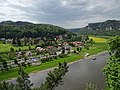
Rathen is a spa town in the Saxon Switzerland-Eastern Ore Mountains district in the Free State of Saxony . It is located below the rocky backdrop of the Elbe Sandstone Mountains in Saxon Switzerland, about 35 kilometers from Dresden . The place belongs to the administrative community Königstein / Saxon Switzerland . Rathen is the smallest municipality in Saxony in terms of population and area.
Local division
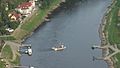
Rathen consists of two districts that are separated by the Elbe . Oberrathen is on the left side of the Elbe on a sliding slope and can be reached by car or S-Bahn. The traffic-calmed district of Niederrathen is on the right-hand side of the Elbe and is connected to Oberrathen by a historic Gierseilfähre , which is a listed building. There are a total of 400 inhabitants in both districts.
Oberrathen

Niederrathen
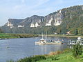
The " Bergland " ferry that connects the two districts
Gier cable ferry on the Elbe between Niederrathen and Oberrathen


tourism
From the state-recognized health resort Rathen, the starting point for tours in the western part of Saxon Switzerland, you get to the Bastei . By Amselgrund you get to by Talwächter and locomotive towered over Amselsee and Rathen . In addition to the old mill from 1567, which is about to be demolished after the flood of the century, a number of other half-timbered houses have been preserved. The Gamrig rises to the east of the village .
Rathen is a popular destination for hikers and climbers , both for day trips, especially from Dresden, as well as for longer stays , due to its surroundings with a multitude of rocky areas and peaks in the Elbe sandstone .
history

Rathen's origins are shrouded in legend. The place was created at the same time as the castles Altrathen and Neurathen . The oldest written evidence is a document from 1261 in which a certain Theodericus de Raten is mentioned. Altrathen Castle, first mentioned in 1289 as a stone castle, lies on a rocky spur above the Elbe valley and today's Niederrathen settlement. Both castles were demolished as robber barons' castles in 1469. Originally, the inhabitants earned their living with shipping on the Elbe , forest work and stone breaking.
In 1919 the Saxon community deaconess house "Zion" was founded in Rathen . In 1924 it moved out of the rooms that had become too small and took its headquarters in Aue . It's part of the community movement . Rathen a Bible and remained setup -Home made that since 1937 the name of "Peace castle" bears (instead of Zion).
During the time of National Socialism there was a satellite camp of the Flossenbürg concentration camp in Rathen with the code name Schwalbe II . A gasoline production project for BRABAG was started in the sandstone . 8 m wide rooms and 14 tunnel entrances were built. A floor area of 80,000 m² was planned. The planned production facility for the production of aviation fuel as part of the mineral oil safeguard plan was never completed. The mouth hole is protected by a strong dry stone wall.
The community was given the nickname "Kurort" in 1935, which has since been part of the community's name.
Today tourism is the main source of income.
Development of the population
|
|
|
politics
Since the municipal council election on May 26, 2019 , the 10 seats of the municipal council have been distributed among the individual groups as follows:
Culture and sights
- see also: List of cultural monuments in Rathen
- Bastei with Schweizerhaus, Bastei bridge and Bastei view
- Rathen rock stage in Wehlgrund
- Rhododendron Park Small Bastion
- Rauenstein
- Amselgrund and Amselfall
- Saxon Switzerland National Park
- Castles Neurathen and Altrathen
- Railway worlds in the health resort Rathen
- Sweden holes
Film productions
Rathen was often a film location. Above all, the Bastei bridge , the Gamrig and the rock stage served as the backdrop. In 1981 and 1984 different scenes for the Police Call 110 series were filmed in the town.
traffic
The Kurort Rathen train station is on the Děčín – Dresden-Neustadt railway line and is served by S-Bahn line 1 of the Dresden S-Bahn . The station used to be called Kurort Rathen (Kr Pirna) . This can still be seen on the station signs today.
literature
- Rathen . In: August Schumann : Complete State, Post and Newspaper Lexicon of Saxony. 8th volume. Schumann, Zwickau 1821, pp. 776-780.
- Hans Brenner: Iron "swallows" for the Elbe Sandstone Mountains. Use of concentration camp inmates to build fuel systems in the final phase of World War II , in: Sächsische Heimatblätter , 1/1999, pp. 9-16
- Richard Steche : Rathen. In: Descriptive representation of the older architectural and art monuments of the Kingdom of Saxony. 1. Booklet: Official Authority Pirna . CC Meinhold, Dresden 1882, p. 77.
Web links
- Rathen in the Digital Historical Directory of Saxony
- Oberrathen in the Digital Historical Directory of Saxony
- Niederrathen in the Digital Historical Directory of Saxony
- Private website about the health resort Rathen
Individual evidence
- ↑ Population of the Free State of Saxony by municipalities on December 31, 2019 ( help on this ).
- ^ Ernst Gotthelf Gersdorf (ed.): Document book of the Hochstift Meissen , vol. 1. Giesecke & Devrient, Leipzig 1864, p. 153, certificate no.190.
- ↑ Rentzing: God alone decides what will be blessed , idea.de, article from July 1, 2019.
- ↑ Homepage of the "Saxon Deaconess House"
- ^ Main statute of the municipality
- ↑ Results of the 2019 municipal council elections
- ↑ Documentation of the GDR-FS / DFF , German Broadcasting Archive (DRA) Potsdam-Babelsberg
Altenberg | Bad Gottleuba-Berggießhübel | Bad Schandau | Bahretal | Bannewitz | Dippoldiswalde | Dohma | Dohna | Village grove | Dürrröhrsdorf-Dittersbach | Freital | Glassworks | Gohrisch | Hartmannsdorf-Reichenau | Heidenau | Hermsdorf / Erzgeb. | Hohnstein | Klingenberg | Königstein (Saxon Switzerland) | Kreischa | Liebstadt | Wages | Müglitztal | Neustadt in Saxony | Pirna | Rabenau | Rathen | Rathmannsdorf | Reinhardtsdorf-Schöna | Rosenthal-Bielatal | Sebnitz | City of Wehlen | Stumble | Struppen | Tharandt | Wilsdruff