
Saint-Priest (Ardèche)
| Saint-Priest | ||
|---|---|---|
|
||
| region | Auvergne-Rhône-Alpes | |
| Department | Ardèche | |
| Arrondissement | Privas | |
| Canton | Privas | |
| Community association | Privas Center Ardèche | |
| Coordinates | 44 ° 43 ' N , 4 ° 33' E | |
| height | 278–1,019 m | |
| surface | 19.15 km 2 | |
| Residents | 1,200 (January 1, 2017) | |
| Population density | 63 inhabitants / km 2 | |
| Post Code | 07000 | |
| INSEE code | 07288 | |
| Website | http://www.saint-priest-ardeche.fr/ | |

Saint-Priest ( Occitan : Sant-Priest ) is a French municipality with 1,200 inhabitants (as of January 1 2017) in the department of Ardèche in the Region Auvergne Rhône-Alpes ; it belongs to the Arrondissement Privas and the Canton Privas . The inhabitants are called Saint-Priéroux .
geography
Saint-Priest is located about 15 kilometers northeast of Aubenas on the Ouvèze . Saint-Priest is surrounded by the neighboring communities of Pourchères in the north and northwest, Veyras in the north, Privas in the east and northeast, Freyssenet in the south, Saint-Laurent-sous-Coiron in the southwest, Saint-Étienne-de-Boulogne in the west and southwest as well Gourdon to the west and northwest.
Population development
| year | 1962 | 1968 | 1975 | 1982 | 1990 | 1999 | 2006 | 2013 |
| Residents | 481 | 486 | 550 | 749 | 968 | 1.107 | 1,194 | 1,265 |
| Source: Cassini and INSEE | ||||||||
Attractions
- Church of Saint-Priest
- Ruins of the Saint-Michel monastery
- Entrevaux Castle
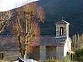
Church of Saint-Priest

Saint-Michel monastery ruins
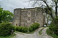
Entrevaux Castle

.JPG)
