
City mill (Heinsberg)
| City mill (Heinsberg)
|
||
|---|---|---|
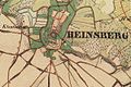
 Heinsberg on the tranchot card 1806/1807 |
||
| Location and history | ||
|
||
| Coordinates | 51 ° 3 '40 " N , 6 ° 5' 35" E | |
| Location | Germany | |
| Waters | Worm , boy worm, mill channel | |
| Built | around 1307 | |
| Shut down | 1905 | |
| technology | ||
| use | Oil and grinder mill | |
| Grinder | 1 grind 1 oil press | |
| drive | 2 water wheels | |
| water wheel | undershot | |

The city mill was a watermill on the Junge Wurm in the town of Heinsberg in the North Rhine-Westphalian district of Heinsberg in the administrative district of Cologne .
geography
The city had its mill site on the boys worm , the mill canal, on the high street in the town of Heinsberg. The land on which the mill building stood was approx. 40 m above sea level . The Dahlmühle was located above the town mill .
Waters
The Junge Wurm was a body of water that ran more or less parallel to the Wurm . The junction from the Wurm was in Nirm, a district of the city of Geilenkirchen . Here the worm has a height of 54 m above sea level. The river Junge Wurm, also known as the Kleine Wurm , flowed in a north-northwest direction via Randerath , Horst , Porselen , Dremmen , Grebben , Heinsberg, Kempen and Karken across the German-Dutch border towards Vlodrop and empties at an altitude of 29 m above sea level on Dutch territory into the Rur . It was a natural body of water in which humans had a hand in many places. The Junge Wurm was connected to the Heinsberg moat , the mill canal, the Liecker brook and the mill brook . This composite body of water served for surface drainage and the benefit of the people. For centuries there were around 15 water mills on the Junge Wurm, with a slope of 26 m between Randerath and Karken. With the worm straightening in the 1960s and 1970s, the young worm disappeared from the maps . Instead, drainage channels and trenches were created. The water association Eifel-Rur (WVER) is responsible for the care and maintenance of the water body with a catchment area of 355.518 km 2 .
history
While in many cities the mills were outside the city walls , in the city of Heinsberg there was not only the external mill Dahlmühle but also a mill within the city walls, which was built around 1300 by the landlord . It lay on the Junge Wurm, the mill canal that flowed through Heinsberg. The mill was first mentioned in a document in 1307 when Gottfried II , Herr von Heinsberg , gave the mill to the miller Gottfried on a long lease for 100 Malter rye annually . In 1542 the mill got a second water wheel . In 1711 the mill with the neighboring buildings burned down, but was immediately rebuilt. In 1808 the town mill was sold as a confiscated feudal property by France together with the Dahlmühle to private hands. The mill building was destroyed in 1944 during World War II.
gallery
Heinsberg on the first recording from 1843

Heinsberg on the new recording from 1893


literature
- Hans Vogt: Lower Rhine water mill guide 2nd edition. Verein Niederrhein, Krefeld 1998, ISBN 3-00-002906-0 , pages 305-306.
- Heinrich Tischelbäcker: The Heinsberger Mühlenkanal home calendar of the Selfkantkreis Geilenkirchen-Heinsberg 1962, page 128-134, 1963, page 142-144.
- Hubert Berens: Die Stadtmühle zu Heinsberg home calendar of the district of Heinsberg 1986, page 22-29
→ See also the list of mills on the Wurm
Web links
Individual evidence
- ^ German basic map 1: 5000
- ↑ Archived copy ( memento of the original from October 17, 2013 in the Internet Archive ) Info: The archive link was inserted automatically and has not yet been checked. Please check the original and archive link according to the instructions and then remove this notice.
- ↑ http://www.wver.de/
At the worm :
Beeretz mill |
Bommers Mill |
Frelenberger Mill |
Horriger Mill |
Hünshovener oil mill |
Grinder and Oil Mill Trips |
Marienthaler Mill |
Müllendorfer mill |
Lohmühle |
Lohmühle |
Eichenthal Mill |
Mill Hommerschen |
Oil and paper mill Oberbruch |
Porselener Mill |
Randerather oil mill |
Rimburg mills |
Süggerather mill |
Interrupt mill |
Full mill interruption |
Zweibrügger Mühle
An der Junge Wurm:
Aldenhover Mühle |
Brünkers Mill |
Dahlmühle |
Horster mill |
Karker Mill |
Kemper Mill |
Lambertz Mill |
Liecker mill |
Powder mill ] |
Schafhausen grain mill |
Schafhausen oil mill |
Town mill |
Valley mill |
Wolfhager Mühle
Am Rodebach :
Brommler Mühle |
Dahlmühle |
Angel Mill |
Etzenrather mill |
Ingentaler Mill |
Isenbruch Mill |
Istrater mill |
Tüddern grain mill |
Millener mills |
Mohrenmühle |
Square mill |
Vollmühle Tüddern |
Wehrer Mühle
An der Schwalm :
Bischofsmühle |
Post mill |
Kornmühle Tüschenbroich |
Kringsmühle |
Lohmühle |
Neumühle |
Oil mill Tüschenbroich |
Rossmühle |
Wegberger Mühle
Am Mühlenbach :
Buschmühle |
Holtmühle |
Meismühle |
Molz mill |
Schrofmühle
Am Helpensteiner Bach:
Dalheimer Mühle |
Helpensteiner Mill |
Rödgener Mühle
Am Beeckbach :
Ophover Mühle
Am Kitschbach :
Kitscher Mühle
Am Knippertzbach :
Knippertzmühle
Am Uebach :
Übacher Mühle