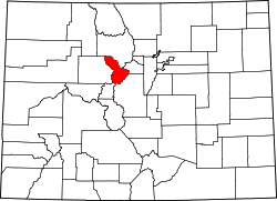
Summit County, Colorado
 Summit County Courthouse |
|
| administration | |
|---|---|
| US state : | Colorado |
| Administrative headquarters : | Breckenridge |
| Foundation : | 1861 |
| Demographics | |
| Residents : | 27,994 (2010) |
| Population density : | 17.8 inhabitants / km 2 |
| geography | |
| Total area : | 1604 km² |
| Water surface : | 29 km² |
| map | |
| Website : www.co.summit.co.us | |
The Summit County is a county in the state of Colorado of the United States . The county seat is Breckenridge .
history
Summit County was formed on November 1, 1861 as one of the 17 original counties of the Colorado Territory. Until 1874 it still consisted of today's Counties Summit, Grand , Routt , Moffat , Garfield , Eagle and Rio Blanco . Summit County is named after the state's numerous mountains and is located in central Colorado.
geography
The county's area is home to numerous ski resorts, Keystone Resort , Copper Mountain , Breckenridge, and Arapahoe Basin . Other tourist areas are in Dillon (Dillon Reservoir) and on Green Mountain.
The Interstate 70 runs through the county, as is the Blue River and the Continental Divide .
Demographic data
| growth of population | |||
|---|---|---|---|
| Census | Residents | ± in% | |
| 1870 | 258 | - | |
| 1880 | 5459 | 2,015.9% | |
| 1890 | 1906 | -65.1% | |
| 1900 | 2744 | 44% | |
| 1910 | 2003 | -27% | |
| 1920 | 1724 | -13.9% | |
| 1930 | 987 | -42.7% | |
| 1940 | 1754 | 77.7% | |
| 1950 | 1135 | -35.3% | |
| 1960 | 2073 | 82.6% | |
| 1970 | 2665 | 28.6% | |
| 1980 | 8848 | 232% | |
| 1990 | 12,881 | 45.6% | |
| 2000 | 23,548 | 82.8% | |
| 2010 | 27,994 | 18.9% | |
| Before 1900
1900–1990 2000 2010 |
|||

According to the 2000 census , the county had 23,548 people. There were 9,120 households and 4,769 families. The population density was 15 people per square kilometer. The racial the population was composed of 91.84 percent white, 0.68 percent African American, 0.48 percent Native American, 0.87 percent Asian, 0.07 percent of residents from the Pacific island area and 3.96 percent from other ethnic groups Groups; 2.10 percent were descended from two or more races. 9.79 percent of the total population were Hispanic or Latino of any race.
Of the 9,120 households, 24.0 percent had children and adolescents under the age of 18 living with them. 44.0 percent were married couples living together, 4.4 percent were single mothers. 47.7 percent were not families. 21.6 percent were single households and 1.6 percent had people aged 65 or over. The average household size was 2.48 and the average family size was 2.86 people.
For the entire county, the population was composed of 17.4 percent of residents under the age of 18, 15.7 percent between 18 and 24 years of age, 44.3 percent between 25 and 44 years of age, 19.4 percent between 45 and 64 years of age 3.3 percent were 65 years of age or over. The median age was 31 years. For every 100 females there were 139.0 males, and for every 100 females aged 18 and over there were 144.9 males.
The median income for a household in the county is $ 56,587 , and the median income for a family is $ 66,914. Males had a median income of $ 33,741 versus $ 27,017 for females. The per capita income was $ 28,676. 9.0 percent of the population and 3.1 percent of families are below the poverty line. This included 4.3 percent of the population under the age of 18 and 3.4 percent of the population aged 65 and over.
Places in Summit County
Passports
The Fremont Pass lies on the border with Lake County . The Vail Pass lies on the border with Eagle County .
Individual evidence
- ↑ GNIS-ID: 198174. Retrieved on February 22, 2011 (English).
- ↑ US Census Bureau - Census of Population and Housing . Retrieved March 15, 2011
- ↑ Extract from Census.gov . Retrieved February 28, 2011
- ↑ Excerpt from factfinder.census.gov.Retrieved February 28, 2011
- ^ Extract from census.gov.Retrieved March 31, 2012
Web links
Coordinates: 39 ° 38 ′ N , 106 ° 6 ′ W


