Watergraafsmeer
| province |
|
| local community |
|
|
Area - land - water |
11.2 km 2 10.36 km 2 0.84 km 2 |
| Residents | 60,440 (Jan. 1, 2010) |
| Coordinates | 52 ° 21 ′ N , 4 ° 56 ′ E |
| Important traffic route |
|
| prefix | 020 |
| Postcodes | 1097-1098 |
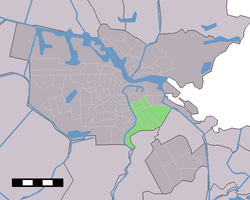
| Location of the Oost en Watergraafsmeer neighborhood in Amsterdam | |
Watergraafsmeer (colloquially De Meer ) is a former district of the municipality of Amsterdam . In 1998 it was merged with the Oost district to form the Oost en Watergraafsmeer district. Watergraafsmeer has been part of the Amsterdam-Oost district since 2010 . Before 1921 Watergraafsmeer was an independent municipality with about 10,000 inhabitants.
The district consists largely of a polder . At the beginning of the 17th century , the polder was created by closing a lake. The name comes from "Watergraftsmeer" - water = water, graft = canal = canal, sea = lake.
It is the main area of Ajax Amsterdam , whose De Meer Stadium is named after this area.
Web links
Commons : Watergraafsmeer - Collection of images, videos and audio files
Individual evidence
- ↑ Kerncijfers wijken en buurten 2009–2012 Centraal Bureau voor de Statistiek , accessed on April 26, 2018 (Dutch)
