Guils de Cerdanya: Difference between revisions
Content deleted Content added
m rm overlink, cleanup using AWB |
|||
| Line 13: | Line 13: | ||
| image_map = |
| image_map = |
||
| map_caption = |
| map_caption = |
||
| pushpin_map = Spain |
| pushpin_map = Spain Province of Girona#Spain |
||
| pushpin_label_position = |
| pushpin_label_position = |
||
| pushpin_map_caption = Location in Catalonia |
| pushpin_map_caption = Location in Catalonia |
||
Revision as of 02:51, 10 November 2016
Guils de Cerdanya | |
|---|---|
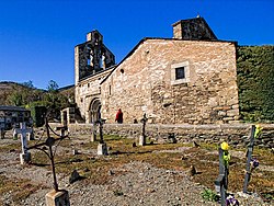
 Church of Sant Esteve. | |
| Country | |
| Autonomous community | |
| Province | Girona |
| Comarca | Cerdanya |
| Government | |
| • Mayor | Valentí Tuset Creus (2015)[1] |
| Area | |
| • Total | 22.0 km2 (8.5 sq mi) |
| Elevation | 1,385 m (4,544 ft) |
| Population (2014)[1] | |
| • Total | 536 |
| • Density | 24/km2 (63/sq mi) |
| Demonym | Guilsenc |
| Time zone | UTC+1 (CET) |
| • Summer (DST) | UTC+2 (CEST) |
| Postal code | 17528 |
| Official language(s) | Catalan |
| Website | guils |
Guils de Cerdanya is a municipality in the comarca of Cerdanya, province of Girona, Catalonia, Spain.
Attractions include the Romanesque church of Sant Esteven (12th century).
References
- ^ a b "Ajuntament de Guils de Cerdanya". Generalitat of Catalonia. Retrieved 2015-11-13.
- ^ "El municipi en xifres: Guils de Cerdanya". Statistical Institute of Catalonia. Retrieved 2015-11-23.
- Panareda Clopés, Josep Maria; Rios Calvet, Jaume; Rabella Vives, Josep Maria (1989). Guia de Catalunya, Barcelona:Caixa de Catalunya. ISBN 84-87135-01-3 (Spanish). ISBN 84-87135-02-1 (Catalan).


