
Branice (Czech Republic)
| Branice | |||||
|---|---|---|---|---|---|
|
|||||
| Basic data | |||||
| State : |
|
||||
| Region : | Jihočeský kraj | ||||
| District : | Písek | ||||
| Area : | 505 ha | ||||
| Geographic location : | 49 ° 24 ' N , 14 ° 20' E | ||||
| Height: | 493 m nm | ||||
| Residents : | 290 (Jan. 1, 2019) | ||||
| Postal code : | 398 43 | ||||
| License plate : | C. | ||||
| traffic | |||||
| Street: | Okrouhlá - Jetětice | ||||
| Railway connection: | Tábor – Písek | ||||
| Next international airport : | České Budějovice Airport | ||||
| structure | |||||
| Status: | local community | ||||
| Districts: | 1 | ||||
| administration | |||||
| Mayor : | Stanislav Češka (as of 2012) | ||||
| Address: | Branice 77 398 43 Bernartice |
||||
| Municipality number: | 549304 | ||||
| Website : | www.branice.cz | ||||


Branice (German Branitz ) is a municipality in the Czech Republic . It is located six kilometers south of Milevsko in South Bohemia and belongs to the Okres Písek .
geography
Branice is located on the left side of the Branický creek in the south of the Milevská pahorkatina belonging to the Central Bohemian hill country. To the northeast is the Ostrovský rybník pond, to the east of the Velký Prachovský rybník. The Lomy (518 m) rises to the northeast, the Šlahoun (514 m) to the south, the Mladšiny (535 m) to the southwest and the Jirouškův vrch (552 m) and the Obora (570 m) to the northwest. The Tábor – Písek railway line runs on the eastern edge of the village, and the state road II / 105 between Milevsko and Bernartice is one kilometer east of the village .
Neighboring towns are Rukáveč and Milevsko in the north, Okrouhlá , Líšnice, Zalerna, Ostrov, U Kunců and Sepekov in the northeast, Laňka, Libeňák, Prachov, Zálší and Křižanov in the east, Jestřebice, Veselíčko and Bilina in the southeast, U Zárubice , Křenovice , Horní Rastory and Dolní Rastory in the south, Podolí I , Myslivna, Jižiny, Podolí and Stehlovice in the south-west, Skalka, Vůsí , Pazderna and Dolnice in the west and Tyrolský Dům and Květov in the north-west.
history
Branice was founded as a settlement on Bechyněer Steig in the middle of the 13th century, according to archaeological finds dating back to between 1240 and 1260 . According to tradition, Branice belonged to the Premonstratensian Monastery of Mühlhausen in 1306 during the time of Abbot Heinrich . The monastery was destroyed by the Hussites in 1420 , and all documents were lost. Then the Klingenberg burgrave Jan Hájek von Hodětín struck the orphaned monastery property of the royal rule Klingenberg. When the Hussites besieged Klingenberg Castle in 1430, King Sigismund pledged the rule to Ulrich II von Rosenberg , because he feared that his burgrave Kunata Kapléř would soon overflow to the rebels. In 1473 Heinrich V von Rosenberg left a quarter of the property of the House of Rosenberg , including the Klingenberg pledge, to his cousin Bohuslav V von Schwanberg . The first documentary evidence of Branice dates back to 1488. In 1575, Christoph von Schwanberg bought the lords of Klingenberg and Mühlhausen from the court chamber on Worlik and connected them with Worlik. After the Battle of the White Mountain , the estate of Peter von Schwanberg was confiscated and in 1621 the Eggenberg owners of the estate. After the male line of Eggenberg died out in 1717, the Schwarzenberg family inherited their property. Until 1736 Branice was the seat of a mayor who also exercised the lower jurisdiction in Jetětice , Jickovice , Kučeř , Květov , Osek , Rukáveč, Stehlovice , Velká, and Vusí. In 1840 Branitz consisted of 21 houses with 218 inhabitants. The pastor was Bernarditz . Until the middle of the 19th century, the village always remained subordinate as part of the rule of Klingenberg to the Fideikommissherrschaft Worlik, including the allodial goods Zalužan, Zbenitz and Bukowan.
After the abolition of patrimonial formed Branice / Branitz from 1850, a municipality in the district and in the judicial district Milevsko. After the Okres Milevsko was abolished, Branice was assigned to the Okres Písek in late 1960 . In 1961 Křižanov and Okrouhlá were incorporated . Both villages broke up again in 1990 and 1993 and formed their own community.
Community structure
No districts are shown for the municipality of Branice.
Attractions
- Chapel of St. Wenzel on Dorfstrasse, built in 1881
- Chapel of the Holy Cross, built in 1931 in the park to commemorate those who fell in the First World War. Next to the chapel there is a mighty protected linden tree and a cross. According to the local history, a chapel dedicated to the Holy Cross on an old plague cemetery should have stood on the site as early as the 17th century. When a storm knocked over one of the two old linden trees in 1929, human bones were found under its roots.
- Niche chapel of St. Saturninus, built in 2006 by the Vejrovské zemanství .
- Annual caricature exhibition Prohledárium of the Vejrovské zemanství association in the former cinema hall of the House of Culture
- Jagdschlösschen Tyrolský Dům ( Tyrolean House ), northwest of the village

Chapel of St. Wenceslaus
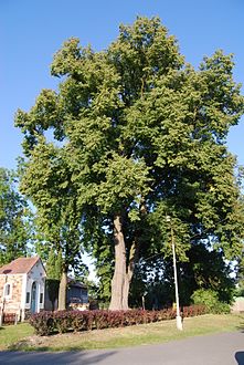
Memorial Chapel to St. Cross with linden tree in the park

Niche chapel of St. Saturninus

House in Branice

_(4.).jpg)
.jpg)
.jpg)
Individual evidence
- ↑ Český statistický úřad - The population of the Czech municipalities as of January 1, 2019 (PDF; 0.8 MiB)
- ↑ Johann Gottfried Sommer The Kingdom of Bohemia, Vol. 9 Budweiser Kreis, 1840, p. 64