
Carnuntum (civil town)


The civil town of Carnuntum or Karnuntum lay directly on the Pannonian Limes , developed parallel to the legionary camp and was the administrative center of the Roman province of (Upper) Pannonia since the beginning of the 2nd century AD . It is one of the most important and most extensively researched ancient archaeological sites in Austria and is located in the municipal areas of Petronell-Carnuntum and Bad Deutsch-Altenburg , federal state of Lower Austria .
The region around a not yet localized Celtic settlement and power center, which the historian Velleius Paterculus called "Carnunto, qui locus regni Norici" (Carnuntum in the Kingdom of Norikum), became one of the central gathering points from the 1st century AD for the expansion of the Romans into free Germania ( Barbaricum ). On the foothills of the Little Carpathians , one of the most important settlement and defense areas in the northern provinces of the empire soon developed. The city owes its rapid rise, among other things, to its favorable location at the intersection of two transcontinental trade routes and at the two military camps , in which up to 6500 men were temporarily stationed. The city was repeatedly the focus of significant historical events during the Roman rule over Pannonia.
Carnuntum consisted of several settlement areas, the legionary camp, a military settlement (canabae legionis) and the so-called civil town, which spread out from the legionary camp to the west outside a security zone of 2.2 km (corresponds to a Celtic league ). The oldest archaeological evidence from Roman times date to the middle of the 1st century. During the reign of Claudius , the civil settlement was built parallel to a permanent wood and earth warehouse with an attached camp village. At the beginning of the 2nd century, around 50,000 people were already living there. Emperor Hadrian subsequently granted her the right to self-government. Under Trajan it rose to the provincial capital of Upper Pannonia. During the Marcomann Wars , Marc Aurel led his campaigns from there to the tribal areas north of the Danube. At the end of the 2nd century, Septimius Severus was proclaimed emperor by the Danube regions and the civil town was then elevated to the rank of colony. This resulted in a long-lasting economic boom in the city. In 308 AD the tetrarchs held the Carnuntum Imperial Conference there . A severe earthquake devastated the region in the middle of the 4th century. This natural disaster combined with the steady reduction in the number of border troops and the effects of the great migration finally sealed the city's economic and demographic decline. In the late 4th century the already very dilapidated place served Emperor Valentinian I as an army camp for a campaign against Transdanubian tribal associations. In the course of the 5th century Carnuntum was abandoned and abandoned by its Romanesque inhabitants. The so-called Heidentor , a triumphal monument from the 4th century and today the landmark of the Carnuntum region, lies between Limes and Bernsteinstrasse .
Surname
The name Carnuntum was taken over from the Celtic predecessor settlement and would refer to the Celtic deity Cernunnos in one of his name forms, since the common root of the names carn means 'horn'. It could also be derived from an Illyrian idiom and mean 'stone wall, stone building, stone city, settlement on the rock or on the stone', but this is assumed to be outdated. Since the time of Emperor Hadrian (117-138), the abbreviation “MAK” for Municipium Aelium Karnuntinum can be read on the relevant inscriptions . Since the reign of Elagabal (204–222) the abbreviation "CSAAK" has been used for Colonia Septima Aurelia Antoniniana Carnuntum .
location

The ancient, ten square kilometers large, populated total area of Carnuntum reached in the west from Petronell-Carnuntum to the Pfaffenberg near Bad Deutsch-Altenburg in the east. This settlement area consisted of the two forts as well as the camp and civil town. The civil town originally extended over the current municipal areas of Petronell-Carnuntum and Bad Deutsch Altenburg. A particular stroke of luck in contrast to most of the other Roman sites in Austria is that, apart from a short period in the early Middle Ages, it was not built over in the following centuries.
The nucleus of the urban development was the area around the legionary camp. To the west of it, 1.5 Roman miles (2.2 kilometers) away, a street settlement for traders and craftsmen was built based on the Italian model in the course of the second half of the 1st century AD. At first it was still legally considered a vicus , as it was about a Gallic leuga (2200 meters) outside of the protected camp area. When the city was actually founded in the 2nd century, there was almost certainly a development plan. At least for the area later surrounded by the city wall, it showed an ovoid hybrid form of rectangle and ellipse (1150 to 525 meters; aspect ratio about 2: 1) with partly straight and partly winding main streets directed to the east-west as well as slightly sloping and partly curved Side streets ( cardines ). The east-west extension was about two kilometers, that from north to south about 1.5 kilometers. In the west their area extended to about 1.5 kilometers west of today's Petronell-Carnuntum in the direction of the Wildungsmauer, corridor Gstettenbreite. In the north it was limited by the steep slope of the Danube with its poorly accessible alluvial forests and its tributaries. In the south, the development extended roughly to the current bypass on Bundesstraße 9 (Amphitheater II).
Carnuntum was annexed to Pannonia under Tiberius . After the province was divided into Pannonia superior (Upper Pannonia) and Pannonia inferior (Lower Pannonia) under Trajan , the place first came to Pannonia Superior and belonged to the newly founded Pannonia Prima (Diocese of Illyria) after the imperial reform of Diocletian . Their territory roughly encompassed today's eastern Austria. The urban territory of Carnuntum originally extended from the northern heights of the Vienna Woods, later from the Schwechat River to the Steinfeld. It also included the Leithagebirge and the northern bank of the Neusiedler See almost up to today's Hungarian border.
Long-distance connections

The Carnuntiner camp, the camp in Vindobona and the auxiliary troop fort in Arrabona secured the Amber Road and the Limes Road as well as the endpoints of heavily frequented highways, two of which met at Colonia Claudia Savaria and from there continued to Italy. Ceramic finds on the territory of Slovakia suggest that Carnuntum was also directly connected to the Waag valley area. Their route probably led over the eastern slopes of the Little Carpathians from the Danube crossing near Bratislava to Trnava .
Research history
The areas of the ancient city area directly on the steep bank of the Danube have plunged into the river through erosion over the centuries. Due to the river regulation at the end of the 19th century, however, these landslides have largely come to a standstill. Large parts of the ancient city area are now used exclusively for agriculture and offer the ideal conditions for large-scale archaeological prospecting projects , such as geophysical measurements and especially aerial archaeological investigations. Since the 1960s, the aerial photo archive of the Institute for Prehistory and Protohistory at the University of Vienna has held more than 1,500 vertical and oblique photographs from the Carnuntum region. Their evaluation yielded a large amount of information on the ancient buildings and infrastructure of the civil city.
13th to 18th centuries
.jpg)

The earliest reference to the ruins of the Roman city is contained in the Descriptio Theutoniae , which a Colmar Dominican chronicler wrote in the 13th century and in which the Heidentor is referred to as the tomb of the giant Theuto. Between 1265 and 1291 a canon from Passau wrote the Vita S. Maximiliani and was of the opinion that Celegia or Celeia had been found in the ruins . Up to the 15th century, large parts of the amphitheater and all four pillars of the Heidentore, among other things, are likely to have stood upright. The Bavarian theologian and chronicler Veit Arnpeck completed his studies at the University of Vienna and also visited Petronell during this time, where he found "... a large amount of marble and other stones". Johannes Cuspinian first correctly identified the ruins as the Roman Carnuntum. In 1534 the scholars Peter Apian and B. Amantius included an inscription from Carnuntum in their directory Inscriptiones sacrosanctae vetustatis for the first time. Johannes Fuchsmagen had ancient coins from Carnuntum brought to Vienna. Wolfgang Lazius described in his work Commentatorium rei publicae Romanae Viennensium commentarii in quattuor libros distincti the remains of Carnuntum and made drawings of the inscriptions found there. Wolf von Unverzagt had in the winter of 1599 on behalf of Archduke Maximilian III. rummage through the ruins for treasure and bring the spoil to the castle of Wiener Neustadt . As in many areas of the ancient city area, the Roman ruins remained visible for a long time in the walking garden of the Petronell Castle. They are clearly recognizable on etchings from the 17th century - which depict the possessions of Count Abensberg-Traun in Petronell (created in 1656 by Matthäus Merian ).
The first known collector of artifacts from Carnuntum was the court librarian of Emperor Leopold I (1658 to 1705), Lambeck. Among other things, he acquired ancient coins, pieces of jewelry and inscriptions from the Petronell farmers. He reported personally to the emperor on each of his trips to Petronell. He planned to publish his findings on “Carnuntum Revidium” (the revived Carnuntum) in book form, but this was never realized. Unfortunately, his extensive records of the condition of the ruins of Carnuntum at that time were also lost later, as the extensive destruction caused by stone robbery only began in the 16th century. Up until the late 18th century, the ruins of the "Heydniche [n] Statt" were almost completely torn down by the peasants because they significantly hindered field work. The stones were reused as building material, the marble was burned to lime. Stones from Carnuntum were even found in the masonry of St. Stephen's Cathedral in Vienna. The centuries of robbery excavations had an even more disastrous effect. The main interest aroused the sarcophagi, as they had the greatest chance of coming across valuable grave goods. Wealthy Viennese antique collectors even commissioned such robbery excavations and added the artefacts found in their private collections. On the occasion of their journey on the Danube from 1736 to 1737, the English educational travelers Jeremiah Milles and Richard Pococke also paid Carnuntum a visit and mentioned it in their travel report. Even then, Milles suspected the location of an amphitheater in the hollow of the green emise. In 1774, numerous Roman inscription stones were walled into the bulk boxes of Traun Castle in Petronell. However, some of them were used as targets during target practice by the Petroneller population in the 19th century and were badly damaged in the process.
19th century
Around 1821, the Prague magazine Hespererus reported on farmers from Deutsch Altenburg who were digging and breaking out old masonry stones as a sideline and sold them “by the fathom ”. In the same year the numismatist and archaeologist Anton von Steinbüchel initiated the first targeted excavations, but this was only a one-man business. The interest in serious research into Carnuntum began with a report by Eduard von Sacken , with which he informed the Imperial and Royal Central Commission about the discovery of the Mithraum Am Stein (Mithraeum I) during blasting work on the Pfaffenberg. In 1884, under the patronage of Crown Prince Rudolf of Austria-Hungary, the Carnuntum Association was founded, with the aim of promoting the scientific investigation of Carnuntum. In 1892 Josef Dell exposed the district in the Tiergarten. In 1894 the KK Archaeological Institute was established. From then on, this and the Limes Commission attached to the Austrian Academy of Sciences were in charge of research into Carnuntum.
20th century
In 1900 the remains of the large thermal baths were discovered. In 1904, the Carnuntinum Museum was opened to present the increasing number of finds in Bad Deutsch-Altenburg . Systematic soil research on the civil town area began in the early 1920s with the uncovering of Amphitheater II by Rudolf Egger and Franz Miltner . Some of the remains of the wall have been preserved or supplemented. In 1938 the German Archaeological Institute bought 70 hectares of the area of the ancient civil town, as the excavations there, on the instructions of Adolf Hitler, were to be continued as a showcase project for archeology research in the Third Reich. Until 1939, parts of the residential buildings in today's Archaeological Park and the Forum thermal baths (palace ruins) were uncovered. They provided completely new insights into the building history of the civil city. Shortly afterwards the work had to be stopped because of the outbreak of the Second World War . Between 1948 and 1957 the ruin area, which is still visible today, was excavated over a size of 1.47 hectares. From the 1950s onwards, land consolidations, the expansion of infrastructure, large-scale material mining, the industrialization of agriculture, etc. led to the destruction of large-scale found landscapes. All these circumstances made rescue excavations necessary under time pressure. Between 1956 and 1978 Erich Svoboda succeeded in completely uncovering the Forum thermal bath, which made it possible to determine its full dimensions for the first time. With the discovery of the cold water basin, its real function could also be determined.
21st century
The most recent excavations, which form a cross-section through the entire history of the settlement, concentrate on a residential area and another thermal bath in the southeast area of the civil town. These Roman buildings, located in the so-called walking garden of Petronell Castle, are part of the Carnuntum Archaeological Park. House I was the first sub-project tackled as part of the walking garden excavation and was examined between 2001 and 2002. In House III, the most complete possible excavation and documentation of those settlement horizons that had remained untouched by the old excavations of 1949–1951 were promoted. The focus of the investigations was the northern area of House III, which had already received the greatest attention in the 1950s. In 2003 the redesign of the area was completed. In addition to the structural measures (renovation of the hypocausts, floors, wall painting), the garden was also replanted. From the holdings of the aerial photo archive, over 100 images were selected for detailed mapping of the archaeological information. This work had already started in autumn 1995, but could only be continued sporadically due to lack of funds. These evaluations were only resumed in 2007 and 2008 and were provisionally brought to a conclusion. In 2005, 2006 and 2007 excavations took place in the small thermal baths in the western part of the so-called Insula VI in the promenade garden of Petronell Castle in preparation for its reconstruction. In 2008, additional excavations took place on the chamber building between the small thermal baths and Villa Urbana. The knowledge gained in this way enables its building history to be traced. In recent years, as part of the 2011 project in Carnuntum, additional excavations have been carried out on terrain that has hardly or not yet been investigated. Most excavation projects have already been completed (House I – III, thermal baths, villa urbana, Weststrasse excavation, zoo, parking lot), individual investigations are being continued. With the help of the results of the old excavations and a reassessment of the current state of research, a scale model of the Roman Carnuntum was produced.
history
The historical development of the civil town was closely related to the constant defensive battles against Germanic tribes across the Danube, which required the permanent stationing of a large number of soldiers. As a result of this fact, the border section at Carnuntum repeatedly moved into the focus of imperial politics, which can be seen particularly in the frequency of the presence of important Roman emperors and generals in the city.
Pre-Roman times
In the centuries before the birth of Christ, the area around Carnuntum was inhabited by Illyrians and Celts . The latter migrated in the 3rd and 4th centuries BC. A. At that time, the Celtic settlement focus was still in the oppidum on the Braunsberg . 100 BC The Celtic tribes of Boier ( Boi ), Skordisker and Taurisker ruled the country. The Boier settled with the Carni in northern Pannonia. The center of their settlement area was in the region between Vienna and Bratislava . Her biggest oppidum was on Castle Hill in Bratislava . The Celtic Carnuntum , the location of which could not yet be precisely localized - perhaps it was identical to the settlement on the castle hill of Bratislava - was probably of greater regional importance even then. Due to the proximity to the Amber Road, the Boisch upper class in particular achieved great wealth, as can be seen from the excavations of this time period. The close economic and political ties to the expanding Roman Empire also contributed significantly to the region's prosperity. A prefect of the border troops, who was also responsible for the supervision of the civitas Boiorum et Azaliorum , is known from a northern Italian epitaph . The Carni are likely to have ruled the area around the Amber Road. The Boian influence extended to western Hungary, Burgenland, Steinfeld (Szombathely), the Vienna Woods and northern Lower Austria. The majority of them settled in small village communities. Around 10,000 of them were likely to have lived in the eastern Danube region of what is now Austria. In the 1940s of the 1st century BC The Boier were subjugated by their eastern neighbors, the Dacians under Burebista , who subsequently also burned the oppidum in Bratislava. After this defeat, the now largely deserted Boi territory ( deserta Boiorum , roughly today's Vienna Basin and Burgenland ) was occupied by the Noriks. Their settlement areas also belonged to the Kingdom of Norikum ( regnum Noricum ) at the end of the first century BC . 15 BC The kingdom of Norikum was agreed as one of the few new areas of the empire, i. H. integrated into the Roman Empire without a forcible conquest.
1st century
The oldest traces of Roman settlement were found for the period between 40 and 50 AD (finds from Upper Italian Terra Sigillata ), when the Legio XV was stationed permanently on the Danube in connection with the expulsion of Vannius and to Vindobona (Vienna) in Carnuntum moved into her second camp on the Pannonian Limes (corridor at Burgfeld). During this time period the ancient Celtic oppida were also abandoned. To the west of the camp, along the Limes road in the direction of Vindobona , the civil town was built in 80 AD. Possibly, after the Celtic hill settlements had moved away, it was also the new capital of the Celtic tribal association ( civitas or civitates peregrinae ) located there. However, immigrants also settled there who, among other things, benefited from the trade on Bernsteinstrasse, but did not want to be under the supervision of the military.
2nd century
.JPG&filetimestamp=20141228234826&)

Due to increased immigration, increased construction activity, promoted by the presence of the Legion, which guaranteed a high level of security, stable economic growth and expanding markets, Carnuntum continued to expand steadily in the course of the 2nd century. After the province was split into two in Upper Pannonia and Lower Pannonia under Trajan, the city advanced to the residence of the consular Upper Pannonian governor between 103 and 107 ( legatus Augusti pro praetore provinciae Pannoniae ). At that time, large public buildings were built, the sewer system was generously expanded and residential buildings were provided with underfloor heating and mosaics for the first time. Long-distance trade with the northern barbarian tribes was an additional driving force behind this continuous upward trend. In addition to everyday items for everyday use, the trade in luxury items also became more and more important. The civil settlement was therefore elevated to the rank of municipality by Hadrian (117-138), probably on the occasion of a visit by the emperor, ( municipium Aelium Karnuntum ). At this point in time, the province's romanization process was probably well advanced. In the following decades, further imposing public buildings (forum complex with town hall ( curia ) and official buildings, temples, thermal baths, etc.) and an elaborate infrastructure were completed. On the ridge of the Pfaffenberg and on the Pfaffenwiese, temples and cult facilities for the supreme imperial god Iuppiter Optimus Maximus and the imperial cult were built.
However, the Marcomann Wars between the 160s and 180s, which were devastating for the Roman Empire, ended the upswing. In the course of the Roman counter-offensive to devastate the Germanic tribal areas north of the Danube, Emperor Mark Aurel (161–180) opened his headquarters in Carnuntum for three years (171–173). There he wrote, among other things, some chapters of his self-reflections before his death in 180 . Surprisingly, the archaeological excavations for this period of time did not reveal a greater horizon of destruction. His son and successor Commodus (180–192) finally concluded an armistice treaty with the Germanic tribes and was probably also in Carnuntum for this purpose. The peace agreement was followed by a period of rapid reconstruction in the Pannonian provinces. On April 9, 193, the most significant historical event for the city took place. The incumbent Upper Pannonian governor Septimius Severus (193–211) was proclaimed by the Danube regions as counter-emperor to Didius Julianus and later also confirmed by the Senate in Rome. He founded the ruling house of the Severi , which brought the empire another massive political and economic boom.
3rd century


Septimius Severus raised the civil city to the rank of Colonia ( colonia Septimia Aurelia Antoniniana Karnuntum ). This made it the most important city in Pannonia superior . The result was another intensive construction activity lasting several decades. The upgrading to Colonia was perhaps also connected with an honor ( deductio ) of a larger number of legionary veterans. Your status as a Roman citizen was thereby enhanced a little more, and the emperor did not incur any further costs. This measure was probably urgently needed after the ravages of the Marcomannic Wars in order to encourage immigrants to settle there permanently. Under the Severians (193-235) Carnuntum reached its economic and cultural heyday and maximum expansion. During the reign of Severus Alexander, the historian Cassius Dio held the office of governor between the years 226 and 228 .
The last decades of the 3rd century were marked by internal unrest, constant defensive battles against invaders and rapidly changing rulers on the imperial throne (so-called imperial crisis of the 3rd century ). Carnuntum remained an important base on the central Danube Limes. 260, during the reign of Gallienus (253–268), the Carnuntine troops proclaimed the governor of Pannonia superior, Regalianus , to be the anti-emperor, but he was not recognized by the Senate in Rome. His influence never grew beyond the Limes strip between Carnuntum and Brigetio . During his brief reign he had coins minted with his image and that of his wife Sulpicia Dryantilla, some of which were found in Carnuntum. Six months later, they were murdered by their own soldiers. Since these coins were only found in Carnuntum, it is assumed that the usurper also set up his headquarters there. With Diocletian's accession to power in 284 the long period of instability among the soldier emperors ended. Upper and Lower Pannonia have now been split into four administrative units. In the course of its extensive imperial reform, Carnuntum entered a final post-bloom period with renewed intensive construction activity.
4th to 5th century

The political conflicts between his successors after his abdication prompted Diocletian, who wanted to prevent the collapse of his system of rule, to convene a meeting of all those involved in Carnuntum in 308 in order to settle the disputes peacefully and to revive the tetrarchy. With this conference being held within its walls, Carnuntum once again moved into the center of imperial politics. Because of its location near the border between the western and eastern parts of the empire and also because of its representative buildings, the city was chosen as the venue for the appropriate accommodation of the delegates. In this historically significant meeting, the Augusti Diocletian, Galerius , Licinius and Maximinus Daia succeeded in putting the distribution of power in the Roman Empire on a new stable basis (so-called fourth tetrarchy ). On the occasion of the restoration of a Mithras shrine (Mithraeum III), the participants donated an altar, which is now kept in the Museum Carnuntinum . During this time, numerous villae rusticae were built on the city territory of Carnuntum and its rural surroundings, which were supposed to ensure the supply of the Limes with food and other everyday goods. One of the last major building projects was a triumphal arch of Emperor Constantius II southwest of the settlement area, the remains of which are known today as the Heidentor .
In the middle of the 4th century (350) Carnuntum was shaken by a severe earthquake. A large part of the urban population probably emigrated as early as the end of the 4th century due to this catastrophe and due to a deterioration in the climate. The general impoverishment of the provincial population also severely affected trade. On the Limes, there were more and more attacks and looting by barbarian tribes advancing from the east. Emperor Valentinian I (364–375 AD) chose Carnuntum in 374 as the starting point for a punitive expedition against the Quaden and Jazygen and stayed there for three months. According to a passage in the writings of Ammianus Marcellinus , the emperor found the city on his arrival as a "neglected, dirty nest" and largely abandoned. Until the last decades of the 4th century, however, extensive construction activities can still be demonstrated in the civil town. The excavations confirmed that at that time large parts of the former settlement area had been destroyed and were only used as cemeteries. Around 376 the Huns crossed the Volga , expelled several peoples to the west and thus triggered the so-called mass migration . In 395 the Marcomanni, Quadi, Visigoths, Alans and Vandals invaded Pannonia without encountering any resistance worth mentioning. The Pannonian Limes collapsed across the board, the unfortified civilian settlements were largely destroyed and then abandoned. The population of Carnuntum withdrew either to the legion camp, to the forum thermal baths or to quarters of the civil city that were still habitable.

After 400 no more major construction activities can be proven there. From 400 to 402 Vandals and Visigoths marched through the area around Carnuntum, but possibly spared the city. In some residential areas, the buildings were still in use until the first half of the 5th century AD. Presumably, more and more Huns, Goths and Avars settled on the city territory. By 433 AD the civil town was probably already completely deserted. In 455 an earthquake devastated the neighboring Savaria, which could also have had an impact on Carnuntum.
Post-Roman times
The focus of the settlement shifted eastwards to Hainburg an der Donau around the middle of the 11th century . The buildings of Carnuntum were demolished by the following generations and their building materials were reused. The centuries-long weathering of blown plant material gradually covered most of Carnuntum's foundation and wall remains (today's ground level is about one and a half meters above the ancient). Only the Heidentor remained visible over the centuries.
| 3d plan of the civil city |
|---|
| Website Roman city Carnuntum |
|
Link to the picture |
administration

Under Hadrian , the city was raised to the rank of Municipium (Municipium Aelium Karnuntum) and under Septimius Severus to Colonia (Colonia Septimia Aurelia Antoniniana Karnuntum). With the granting of the right to self-government, its residents automatically rose to become Roman citizens ( civitas Romana ). Now a separate city senate could also be elected. Members of the indigenous population, especially those of the old tribal aristocracies, were also accepted into the city council. So was z. B. the Boier Titus Flavius Probus member of the Council of Hundred. His son was later also appointed decurio and later even rose to knight ( eques ). Presumably, the Municipium and Colonia did not have the full Roman, but only the minor Latin legal status. The city was ruled by a council assembly ( ordo decurionum ) consisting of a hundred members ( decuriones ) , which met regularly in the town hall at the forum ( curia ). At its head was a college consisting of two men ( duumviri ), the duumviri iure dicundo. They spoke rightly, controlled the city's finances, levied taxes and raised troops if necessary. The maintenance of public order, the administration of public buildings, the maintenance of the streets, market supervision, the organization of public games and the supply of grain to the population were the responsibility of the aediles , who were directly responsible to the college of two. Two quaestors were in charge of the municipal financial administration . The curatores thermarum were responsible for the administration of the public baths and the curator aquarum for the organization of the water supply . The administrative district Carnuntum was divided into village communities and districts ( vici and pagi ). Two of them are also known by name; the vicus Gallorum and the pagi Aelenus .
Road system


The civil town was evidently oriented, like the neighboring Canabae, according to the long-distance traffic routes and the roads leading out of the camp gates. The internal, axial street system was laid out so that the main streets led directly to the most important buildings (e.g. forum, thermal baths, amphitheater II). The starting points were the two main streets of the camp, Limesstraße and Bernsteinstraße. The street grid may have been based on a plan, but it was not laid out exactly at right angles, so that the dimensions of the individual insulae varied greatly. In any case, no regularity can be seen in the city map. Especially in the center of the settlement on both sides of the Limesstrasse, radially branching streets with significant changes of direction could be observed. They probably originated from the slow merging of earlier scattered settlements .
The Limesstrasse, approaching Vindobona (Vienna) from the west , turned slightly to the north at Gstettenbreite and then continued in the city's decumanus maximus , which stretched from west to east in the city center next to the Großer Therme and Forum. It has been archaeologically proven in the promenade south of Petronell Castle. From there it led directly to the legion camp. The branches in the south of the decumanus formed the north and south roads, sections of which were exposed in the promenade. The cardo maximus running from north to south led east of the forum and the large thermal baths in a south direction to the Bernsteinstraße (connection with today's Bruck an der Leitha). The streets of the civil town were 4.5 to 12 meters wide, mostly paved with polygonal stone slabs and provided with canals and in some cases with elevated sidewalks or accompanying porticos. Their pavement was mostly gravel or mortar, paved sections like in the area of the Archaeological Park could only be observed very rarely.
Building structure


The previous excavations in the promenade garden showed that all known Roman house types were present there, from the elongated strip house to courtyard houses with several tracts to peristyle houses; in most cases, however, their floor plans and construction periods are not sufficiently known or cannot be precisely determined. The first buildings consisted of simple wood and clay constructions. During excavations in the inner courtyard of the Forumstherme, remains of the early civil settlement came to light. They came mainly from half-timbered buildings that were destroyed by fire in the second half of the 2nd century AD. By the early 3rd century, most of the wooden houses were replaced by more comfortable and well-equipped stone buildings. The luxurious furnishings of private residential buildings and public buildings of this time were evident at many excavation points. Since its elevation to the municipality of Carnuntum, the civil Carnuntum also had a forum as the urban and mercantile center of the city, several temples, a council building, a city archive with writing offices and several thermal baths, including the forum thermal baths, which were long erroneously referred to as palace ruins, or the smaller thermal baths in the walking garden, Today's Carnuntum Archaeological Park was rebuilt on its original foundations. The houses were built close to one another and some had richly furnished gardens. The larger streets were flanked by porticoes. The building blocks ( insulae ) varied in size from 37.5 × 75 (city center) to 100 × 100 meters. Since early Severe times, they were also surrounded by a city wall. In front of the wall, however, there were also densely built-up areas, which spread out in the south to Amphitheater II and to the west and east along the Limesstrasse. With its upgrading to a Roman colony, the lavishly constructed private and public buildings gave the civil town a capital city character. The civil town reached its maximum extent between the 3rd and 4th centuries with a built-up area of 67 hectares.
Forum

The economic and administrative center of the civil town was localized in 1996 by means of georadar and magnetic investigations south of the large thermal baths. The 142 × 65 meter building complex stood south of the decumanus maximus , the course of which can be equated with that of the Limes Street. The ground plan could be reconstructed fairly exactly with the help of geophysical measurements (geomagnetics, ground radar). The monumental building was oriented from north to south and covered an area of 9900 square meters. The surrounding functional buildings spanned a 47 × 55.5 meter square. In the west and east there were colonnades ( portikus ) with business premises ( tabernae ) behind them . In the north stood a basilica oriented from east to west with tabernae in front , which opened to the decumanus maximus . The south side of the forum was occupied by a 65 × 45 meter, three-part building complex, which presumably served as the seat of the city administration. The front of the middle hall (11.7 × 12.9 meters) protruded over the vestibule; it served as a kind of cult room. The eastern room (9.9 × 13.2 meters) was equipped with underfloor heating, which makes it likely to function as a tabularium (archive room and typing offices) or curia (meeting room). Behind these halls were smaller rooms and an open portico with the entrances to the official buildings.
Forum thermal baths (palace ruins)


To the west of the Meierhof of Petronell Castle are the remains of an extensive, multi-phase thermal bath, which for a long time was mistakenly viewed as a purely representative building. It was only when Herma Stiglitz examined room 30 in the northeast part of the building in the late 1960s that its true function could be clarified. It is one of the most important Roman structures of this type that could be found north of the Alps. Presumably in Severan times, the 104 × 144 m thermal baths were built immediately north of the forum. The architects had to have the site leveled beforehand. The load-bearing walls of the thermal baths were 0.95 to 1.45 m thick and consisted of boarded quarry stones with joints. They were probably once 12 to 15 m high. The last changes were made towards the end of the 4th or the beginning of the 5th century.
The main wing in the north consisted of 40 rooms of different sizes. They were once lavishly decorated with marble slabs on the floors and walls, stucco decorations and wall paintings. The actual bathrooms of the bath complex were also located there. The central hall with the 21 × 9 m and 1.60 m deep water basin with a semicircular end was located in room 30. The drain was laid out with marble. Room 33 housed the cold bath with two apsidal water basins. The undressing room was in room 31, from which the swimming pool could be entered. Room 36 had a marble floor. The hot and leaf bath was located in rooms 9, 20 and the surrounding rooms. A network of canals ran under the thermal baths, providing for the inflow and outflow of water. The process water was fed into a collecting canal in the west of the north wing.
A large, open, rectangular courtyard separated the southern part of the thermal complex from the northern part. In terms of architectural history, this courtyard is part of the south wing, which leads to the assumption that the bathrooms were not built until later. The south wing mainly consists of a small courtyard, which is surrounded on three sides by 16 chambers. Two octagons and a round building in the middle served either as water reservoirs or were cult buildings. To the south, a large market hall ( macellum ) with a portico measuring 104 × 4 m, which opened towards the decumanus maximus , was in front of the thermal baths along their entire length . Finds such as a genius statue and an altar for the collegium fabrum (association of the municipal fire brigade) in room 7 indicate that it was probably also used for official occasions. The dedicatory inscription on the altar says that it was donated by Faustinianus, a member of the city aristocracy.

Findings plan of the forum thermal bath (as of 1976)
Remains of the forum thermal baths ("palace ruins")


city wall
The construction of the city wall could be dated to the reign of Septimius Severus through more recent excavations in the southern area of the civil city and related to the elevation to the colonia . The wall enclosed an area of around 1100 × 550 meters and was 2.10 meters wide. It consisted of an approx. 1 meter wide core of mortared rubble stones ( opus caementicium ), which was paneled on both sides with rectangular cut stone blocks. The construction stood on a 0.50 meter deep slab of cast mortar. There were at least six gates, but only the west gate could be examined more closely. At least at the corners, the wall was reinforced with towers. An intermediate tower also appears to have stood at Amphitheater II. It has been archaeologically observed several times in the west and south of the area. Its eastern section ran between today's Mithrasgasse and Lange Gasse. In the north it stretched along the steep bank of the Danube. In the south, remains of a moat could also be detected. During an emergency excavation at the parking lot of the visitor center, a poorly preserved section of the wall with a pointed ditch in front was uncovered along the state road. When the city wall was being built, some ovens were installed there. Presumably they served to feed the construction crews. The area north of Wallstrasse ( via sagularis ) was later built over. The findings revealed three construction phases, which prove that the site was used until the late 4th century. In the east of the fish pond (zoo), an approx. 100 m long section of the city wall was again uncovered in 2012 during an emergency excavation. In the north the foundations of the west gate were uncovered. A graveled road embankment lined with low walls led through the gate to the decumanus maximus . Perhaps it was built as a layer of wooden planks over the walls. However, no traces of this could be found. Even to the south, only the foundations of the wall were visible for a longer stretch. At the south-west corner of the excavation area, it was still several flocks high, and a tower attached to the inside could also be detected there. The 350 earthquake probably damaged the fortification so badly that most of it had to be demolished afterwards.
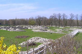
Partly reconstructed district in the walking garden


A typical urban district for the civil town was exposed in the walking garden near Petronell Castle (i.e. approx. 0.5% of the city area), the walls were restored or preserved. Its area has a steep, terrace-like gradient to the north (Danube bank), which divides it into a north and a south part. The buildings excavated there from all epochs of Roman rule are separated from each other by small alleys and corridors as well as streets of different widths. The first buildings were simple half-timbered buildings based on Mediterranean models, which were replaced by Gallo-Roman court or strip houses in the 2nd century . Four of these buildings have recently been rebuilt true to the original (as they were in the 4th century) and made accessible to the public. The reconstructions are planned in such a way that the original building fabric is retained in full and can be shown again, even after the extensions have been removed.
Street system: The quarter was bordered by four streets. Except for the pavement that is visible today, they were uncovered and labeled according to the four cardinal directions: south, west, north and east streets. The first solid roads were laid out in the Flavian era (north and south roads). The road horizons were multi-phase and initially only had a gravel surface. In the early 3rd century, stone slab paving was laid over it; Side canals drained them.
Sewer: The earliest canals made of brick slabs date from the 2nd century. The installation of a fresh and sewage system (stone water basin with several underground channels) took place in the time of Hadrian.
South terrace
There, on both sides of the access road to the castle, antique houses with workshops, gardens and small courtyards of different sizes were discovered (House I − Vb), so-called arbor or central corridor houses. The long rectangular parcels were at right angles to the cobbled streets. Business premises ( tabernae ) opened up on the street side . Behind it were the living quarters of the shopkeepers. The south terrace is closed off by the six meter wide south road (course east to west) and supported by a massive wall because of the steep slope.
House I.


The multi-phase building complex (phase I-VI) measured 54 × 17 meters and was divided into a north wing, a central core building consisting of several rooms and a south garden. The earliest building, still entirely made of wood, dates back to the reign of Domitian. A dome oven inside was probably used for cooking and baking bread. Perhaps the building was already fulfilling an economic function back then.
Around 125/130 AD it was demolished and the area leveled. Then a multi-segmented building was built with adobe walls on stone foundations. The new building was pulled back by about 5 meters towards Südstraße. In the courtyard there was a small furnace that may have been used to make glass. Shortly after the middle of the 2nd century there was a complete renewal of the building fabric. At the same time, the property was enlarged a little to the west. Now a rectangular building was built with massive, mortared quarry stone walls and screed floors. The rising one probably still consisted of half-timbering. A large garden was laid out in the south. Around 200, some minor alterations were made again, only a few changes were made to the core structure. He was only given a veranda-like extension in the north. The living comfort, however, was significantly improved by applying wall paintings and installing underfloor heating. Another heated room with a northern vestibule was added to the west. A brick sewer channeled the sewage into the main sewer that was built at the same time under Südstraße.
At the beginning of the 4th century the building was badly damaged by fire and redesigned again. The annex in the west was particularly badly affected. Its outer wall therefore had to be completely rebuilt. A bathroom was added to the northern extension. An additional, transverse corridor was added to the core building in the south. The garden was raised a little in the north and partitioned off with a wall. The rooms that opened up to Südstrasse were now presumably used for commercial purposes. In the area of the destroyed western annex there were the remains of a blacksmith's workshop. A mosaic floor and wall frescoes in room A showed that the owner of the house probably had considerable financial resources. The earthquake of 350 also badly damaged House I. The apparently slow start of reconstruction was limited to a two-room structure that was built into the southeast corner of the destroyed core building. The southern living room had again been fitted with underfloor heating. To the north was a kitchen with a stove and the prefurnium for heating the living room. The north courtyard was filled in. The street-side installation was divided into smaller chambers that were open to the Südstraße and were probably used commercially by adding several new intermediate walls.
House II (House of Lucius)


This building was the first object in the promenade that was rebuilt from 2006 onwards using the means of experimental archeology on the original foundations with fully functional infrastructure at the level of construction period V. For the first time, a Roman hypocaust heater could be reproduced here down to the smallest detail and tested in practice.
One of its alleged owners, Lucius Maticeius Clemens, could be identified with the help of an inscription on a consecration altar that was discovered during an archaeological investigation in 1951. In the garden of the house, next to a small cult niche, a 69 cm high altar made of sand-lime stone was discovered that had been donated to the nymphs by the owner of the house . His three-part name reveals that he was a Roman citizen and descended from Celtic-Illyrian ancestors. The gentile name Maticeius / Maticius was common in southern Gaul and Hispania . Lucius belonged to the upper Carnuntine middle class. Obviously for a trading center, he probably earned his living as a trader. During the archaeological investigations, no traces of material residues were found that would indicate a craft that used raw materials. Lucius probably worked as a cloth dealer.
Its foundation walls were exposed from 1948. The building history of the house could be divided into six construction phases. The construction of the 1st and 2nd centuries (phase I-III) consisted of residential and farm buildings with walls made of clay and half-timbered, hearths and mortar floors. The rainwater, particularly in the east of the area, was drained off by means of a drainage ditch. In period IV (first half of the 3rd century) the first stone building was erected, a core building with a rectangular floor plan, divided into several rooms and a north courtyard. In period V (first half of the 4th century) the core building was removed again and replaced by a much larger building with two extensions, brick or screed floors and hypocaust heating. Period VI was difficult to grasp due to the ransacking of the area in the 1950s. The north courtyard was extended to the south street. Presumably the core building was also redesigned.
Between 2003 and 2005 his area was thoroughly examined again in order to prepare the reconstruction work. Many of the finds recovered in the process allowed a detailed insight into the everyday life of the house residents. House II stands on a trapezoidal parcel with an area of 1100 square meters. The self-contained building complex from period V consisted of a courtyard in the north, beginning on Südstrasse, with timber-framed farm buildings, the actual, one-story house and a walled garden in the south. The core building, oriented from east to west, measures 14.8 × 24 meters and has a floor area of 355 square meters. It is divided by a corridor running from north to south, from which a room can be entered on either side. In the south it is closed by an extension. In the north there is a small graveled inner courtyard for room lighting, the kitchen, the prefurnium for the hypocaust heating and another extension through which the house can be entered. The masonry consists of lime mortar-bonded rubble stones, plastered with lime mortar and the interior is painted with lime colors green, red, yellow and black. Brick powder was added to the external plaster, which gave it a terracotta-like color and improved the quality of the plaster. The interior walls consist of clay rod plaster walls on stone foundations. The window frames are fitted with hand-blown cast glass and shutters. The archaeological investigations did not provide any information about the use and equipment of the upper rooms, which is why only the ground floor could be completely reconstructed and equipped. Originally, the first floor was almost certainly also inhabited. The interior of the house reflects the lifestyle of a middle-class Carnuntine family in the first half of the 4th century. The main living room (room A) can be heated by means of underfloor heating, a simple double-T-shaped hose heater on brick pillars. On the upper floor there was probably a bedroom for the servants or a storage room. The smoke gases were discharged into the open through clay hollow bricks ( tubules ) in the walls and through chimneys on the roof. The gable roof of the residential wing and the monopitch roofs of the front building are covered with ledges and semicircular tiles (roof tiles, tegulae and mortared covering tiles, imbrices ). The V-shaped wooden gutters attached to the roof edges are hypothetical, but absolutely necessary for precise rainwater drainage. To the north-east of the building, two kilns made of clay with wooden pillars for ceramic production were reconstructed based on original finds.
| Reconstruction data | numbers |
|---|---|
| Built up area: | 335 m² |
| Usable living space: | 250 m² |
| Roof area: | 390 m² |
| Stone masonry: | 250 m³; Weight approx. 1000 to |
| Reclaimed wood requirement: | 30 fm |
| Lime plaster inside: | 1,050 m² |
| Clay / rod plaster walls: | 160 m³ |
| Heating temperature / prefurnium: | 600 degrees |
| Heating temperature after 13 running meters: | 50 degrees |
| Planning effort / architect: | 800 hours |
| Construction: | 50 weeks |
House III


The building was divided into a northern wing, consisting of four rooms with a small inner courtyard and a southern wing with a larger courtyard and two other rooms. A total of seven different construction periods could be identified between the late 1st century AD and the second half of the 4th century. The earliest building horizons could be dated to the late 1st century. A covered walkway along the south side of Südstrasse delimited the plot to the north. Extensive additions could be identified for the middle of the 2nd century (period III). The insula was walled in in the north and east with an adobe wall on a rubble foundation. The plot may have been delimited in the same way in the south. A 6.75 × 4.30 m mud brick building was attached to the east wall, which had been withdrawn about 16.80 m from Südstraße and consisted of two rooms of approximately the same size. These rooms, to be entered from the west, had a U-shaped hose heater. The corresponding prefurnium stood on the south wall. The building was probably used as a kiln . To the north of this kiln and parallel to its north wall ran a 1 meter wide structure made of dense clay at a distance of about 2.25 m. Starting from the east wall of the insula, the clay step formed a boundary rising to the west and at least up to 0.40 m high to the north.
In the early 3rd century, it was completely redesigned according to the then latest structural engineering standards. For the first time, the presence of stone architecture could be consistently demonstrated there (period IV). The east and north walls of the insula were completely rebuilt. In the south, a common boundary wall to houses I-III was created. Another quarry stone wall running off the insula east wall in a bond to the west now separated house III into a north and a south part. To the east of the core structure of House II, the east-west dividing wall bent to the south and separated the southern complex of House III from the south garden of House II. The north wall of house III extended from the early 3rd century to the parcel of the neighboring house II. Through an approximately three meter wide gravel driveway, which probably led through a gate in the north wall, one could get out into the area in front of the Get the core of House II. Another entrance was to the west of the north courtyard. A brick canal started northeast of the core structure of House II, ran along the east wall of the western courtyard area and ended in the main canal under Südstraße. Another sewer under the alley between House III and House IV was further evidence of the significantly improved infrastructure. It too flowed into the canal under Südstrasse. The period IV building remained in existence for a very long time and without major changes.
In period V the west wall of the northeastern courtyard area was removed and completely renewed. In the southern line of the east wall of the northwestern courtyard area of House II, a new partition wall with a narrow passage was installed as a privacy screen. Due to the elevation of the Südstraße in the early 4th century, the canals that led from the southern perimeter to the main canal had to be increased.
In period VI, around the middle of the 4th century, the area north of the core building of House II was completely redesigned and re-parceled out. The north wall was torn down and rebuilt at a higher level. An elongated room was built in front of it, the end of which on Südstrasse was now in line with the northern front of House I. Presumably it was used as a shop. To the south of this newly created building, another wall was raised, which reached to the north front of the core building of House II and divided the north area in front of the core building into a smaller western and a larger eastern section. In the eastern plot of this northern area there were two rectangular courtyards located next to each other. There was a fountain in the south-west corner of the eastern courtyard. A living room with a primitive cross-channel heating system had been created south of the courtyard. These serious changes in the structure of the entire building were probably related to a change in ownership or its functions. The reason could have been the great earthquake in the middle of the 4th century. For the second half of the 4th century, far-reaching changes in the infrastructure could also be observed (e.g. water supply and sewage disposal). The fountain in the east courtyard indicates the obvious decay of the central water supply. This also applies to the sewage system. In the middle or the second half of the 4th century the central main collector under the Südstrasse was removed and filled in. During the construction of the business premises on Südstrasse, the western cheek of the canal between House III and House IV was destroyed and made unusable. The sewer to Südstrasse was also no longer in operation at this time.
It is uncertain when House III was abandoned by its residents; it was probably used at least until the last quarter of the 4th century.
House IV (Domus Quarta with floor mosaic)

This building was the fourth object in the promenade garden, which was partially rebuilt on the original foundations from 2013 using the means of experimental archeology. The area of this house was exposed in the early 1950s. During the excavations, the archaeologists found the only Roman floor mosaic from Carnuntum that had survived in one of the larger rooms. The room may have served as a dining room ( triclinium ) in the warm seasons . After the end of the excavations, the mosaic was first covered with soil again to create the best possible conservation conditions. Subsequent excavations between 2008 and 2011 brought new insights into the social status of the former homeowner. They made it possible to divide the building history into seven construction phases. The foundations were still in good to very good condition. Even some remnants of the masonry that rose up had stood the test of time. Subsequently, the archaeologists also found a small bath house and a separate water pipe that could be traced to the Roman city wall. This proves the high social status of the former landlord. Before the building was rebuilt, the mosaic was removed, restored and embedded in a new carrier material. Finally, in 2013, in order to protect and present this culturally and historically significant artefact, the surrounding residential building architecture was restored as a partial reconstruction using ancient construction technology up to the eaves. After the construction work was completed, it was moved back to its original location.
In phase I (middle of the 1st to 2nd century) a hill rising to the east in the southeast of house IV was leveled, then a narrow, hall-like building oriented from east to west was erected in the south of the area. Swell trenches, post holes and pits from this construction phase could also be observed in the later courtyard and in the area of the later core building. These structures were probably used for residential and commercial purposes. A barrel well in the core area of the area, the wooden cladding of which was still well preserved when it was discovered, served to supply water. The wood was felled or processed in the year 93 AD. In the southeast of the area, the remains of a wooden pipeline fed by groundwater from the same time period were uncovered. In phase II (early 2nd century AD) the site was extensively leveled. At that time there was a simple wooden building in the south. Swell trenches with associated post holes were found in the west courtyard. Presumably there was the more massive, rectangular core structure, which was framed by ditches (drainage?). In phase III (mid-2nd century AD) the site was leveled again. For the first time, a clear delimitation structure to the parcel of house IV a could be demonstrated in the west. In the north of the core building, a rectangular cooking area made of rubble and clay was discovered. A layer of bricked clay and charcoal deposits was observed in the courtyard area of this time. Either the courtyard was used commercially or the core building of construction phase II had been destroyed by a fire. In the west of the area, another quarry stone building was found, which apparently formed the south and east boundaries of the parcel. In phase III the plot was obviously surrounded by solid stone walls.
In phase IV, at the beginning of the 3rd century, major renovations took place again. The core building of this period consisted of solid, mortared quarry stone walls and was equipped with terrazzo floors and underfloor heating. The dining room in the south was decorated with the multi-colored floor mosaic. From the south-east to the north of the excavation area, the remains of a freshwater pipe (a masonry and accessible, underground aqueduct) from this time have been identified. In phase V (last third of the 3rd century) a bath was added to the core building in the south. The water was supplied through a lead pipe from a well house in the south of the courtyard area. The floors in the central corridor and in the northwest area of the core building consisted of brick mosaic. In the west of the courtyard, which is paved with sandstone slabs, remains of a rectangular building with eaves draining to the west could be observed. A furnace and several wall sections from phase VI (middle of the 4th century?) Were uncovered in the courtyard area. A round well shaft framed with quarry stones also seems to come from this period. The south wall was reinforced on the building in the west area of the courtyard. All the walls were built in shell construction. Some structural changes were also made to the core, including the installation of a hose heater. The findings in the western area of the courtyard from construction phase VII (end of the 4th / beginning of the 5th century) provided valuable information for the late antique settlement history of the civil town. A pit filled with rubble and metal waste, walls built after the pit was filled, and minor alterations date back to the early 5th century.
House Va and Vb

During the excavations in 2011, a total of four construction phases could be identified (1st to 4th century AD).
House Va: Its area was probably used in the late 1st century to extract earth. Some post holes and beam trenches also date from the early 2nd century, but so far it has not been possible to complete them into complete floor plans. At the end of the 2nd or the beginning of the 3rd century the basic structure of the strip house was created. At the same time, a well shaft was built south. In construction phase III, a canal bordered with wooden boards was created with a connection to the canal on Südstrasse. It was later replaced by a channel made of rubble stones, which was covered with heavy sandstone slabs. Due to the destruction caused by the earthquake, it had to be abandoned because the canal of Südstrasse was also badly damaged. In construction phase IV (approx. 300) the existing walls were renewed; A small bathroom was set up in the north-west corner of the building. Its sewer was laid out with brick slabs and connected to the canal on Oststrasse. The floors partly consisted of a mortar screed. After the earthquake of 350 (phase V) the building was rebuilt.
House Vb: The subsoil of this building was also initially used to remove humus. A deep pit at the edge of Südstrasse could have been a well shaft. Subsequently, a simple, hall-like building, open to the south, was erected in wood. It was removed again in Phase II and replaced by a new hall with the same orientation. In construction period III, a rectangular half-timbered building with several rooms (14 × 11 meters) was built in the same place. The associated fountain stood on Südstrasse. In phase IV, the house was completely rebuilt in stone on the foundations of the previous building. The area on the street was also enclosed with a quarry stone wall. In phase V the courtyard walls were torn down again and partially rebuilt. After the earthquake of 350, a simple hose heater with a T-shaped heating duct was installed in one of the rooms.
North terrace
Their building structures differ significantly from those on the south terrace, which is three meters higher. There were three closely related individual objects. To the west is the rebuilt bathing facility, to the east the preserved foundation walls of the chamber building. In the northeast, a small Diana shrine was first reconstructed. It later emerged that it was actually the entrance hall to Villa Urbana. This was also rebuilt true to the original. The southeast corner of the terrace has not yet been exposed. The multi-phase north road (course east to west) was excavated on its northern edge. It was lined by a continuous portico with sidewalk, which has now been restored on its south side. In it were the entrances to the thermal baths, the paved courtyard of the chamber building and the Villa Urbana. The road surface consists of limestone and granite slabs and still has clearly visible groove marks from wagon wheels. In the middle runs a 1.20 × 1.20 meter sewer from the 2nd century with a double tile floor. It is covered with two-ton limestone slabs. At a canal intersection, it flows into the collecting canal of Weststrasse, which drains north into the Danube.
Portico
The building, which extends from east to west on the south side of Nordstrasse, was built in the 3rd or 4th century and served as a covered pavement, entrance hall for the buildings behind and weather protection for small shops, cookshops, etc. The column shafts of the building are made of white painted Wood, the bases and capitals made of limestone, the foundations made of rubble stones bonded with lime mortar (Leithakalk). Presumably the northern sidewalk of Nordstraße was built over with such a portico.
Villa Urbana


From 2005 to 2007 a representative building was completely excavated to the north-east of the chamber building except for its southern section. It was the second object in the promenade that was rebuilt from 2008 using experimental archeology on the original foundations with a fully functional infrastructure. The area of the reconstructed or rebuilt building is around 600 square meters, whereby only the representative rooms were taken into account, and corresponds to the expansion stage around AD 295 (phase V). The entire building complex originally extended to the supporting wall of Südstrasse. More detailed archaeological investigations are still pending there. In contrast to the house of the cloth merchant Lucius, there were no epigraphic clues that could provide information about the residents of the city palace at that time. The discovery of over 30 square meters of richly decorated wall painting was an extraordinary stroke of luck for science. The painted wall plaster was removed in a later construction phase and leveled with the rubble. The assembly of the fragments into a usable template was correspondingly complex. After years of meticulous work, it was possible to largely reconstruct the original appearance of the wall painting. Sculpture fragments and remnants of marble paneling also testify to the extremely luxurious furnishings of the individual rooms.
The complex known today as villa urbana comprised a total of eight construction phases and a number of small-scale structural changes.
Phase I-VIII: In the last third of the 1st century AD, there were initially several simple wooden post buildings. Presumably one of them was used for the extraction, perhaps also for the storage (air drying) of clay and earth bricks. In the first third of the 2nd century, the post structures were replaced by a long rectangular, east-west oriented core structure made of stone (phase II). A rod wall separated it into an east and a west half. Both the west and east walls protruded beyond the southern corners of the building. Another building stood in an enclosed courtyard area. There was also a hearth, a storage jar sunk into the ground, and a building made of clay and earth bricks. A well had been dug between the two buildings, and it was abandoned when the clay-earth building was destroyed. Immediately to the north of the stone buildings there was a pillar structure oriented from east to west. There was a box-shaped well shaft at the western end. In the west and north, the pillar structure was surrounded by an exposed gravel surface that sloped slightly towards the north road. In the middle of the 2nd century the pillars and the courtyard were surrounded by a stone wall. A well room was built around the box well, with courtyard areas in front of it in the north and west. The core building of phase II was redesigned twice during phase III. Among other things, he received a room with hose heating, other rooms were decorated with white and red stripes. The courtyard areas were gravel. To the south of the roofed core building there were perhaps shelters or huts that were possibly used to store and process grain.
At the beginning of the 3rd century, the pillar and core structure were replaced by a building with three heatable rooms. The associated infrastructure areas and prefurnas were arranged south of the street hall. The entrance was now a square vestibulum with a corridor to the south. After the box fountain was closed, the well room probably served as a quarter for the craftsmen and construction workers involved in the construction. In one of the courtyards, the remains of five dome ovens were exposed. The so-called east hall was built on Oststrasse, which was connected to a veranda from phase III in the south and bordered the associated courtyard to the east. A small bath was uncovered in the south, which consisted of a horseshoe-shaped cold water basin and in the east of partially heated rooms.
At the end of the 3rd century, the bathhouse was connected to the western street hall, a two- room outbuilding was built and the eastern hall was considerably expanded with a large flight of stairs and the addition of an apse to the main room from phase IV. A heatable loggia facing east was integrated into the west corridor. Mosaic pavements in several rooms, sculpture fragments, remnants of marble paneling and numerous plaster fragments with wall paintings are evidence of the elaborate interior design. However, the function of the building in construction phase V is still unclear. Some architectural features and the wall decorations suggest either the seat of a club ( collegium, schola ) or - more likely - the residence of a wealthy magnate.
Because of the apparently massive destruction caused by the earthquake in the middle of the 4th century, the villa underwent massive renovations. Various repair measures were observed in several places, especially in the southern corridor area. The older hypocausts were filled in, and some of the heating systems had to be completely rebuilt. The east hall in particular showed gross structural damage, which could only be repaired through extensive repairs. Among other things, the floor was renewed and a kind of post structure was set up in the north of the hall. Probably the roof was no longer or only partially intact at this point. The bathing wing was also rebuilt, with a slightly different layout. In the simultaneous leveling shifts there were large amounts of fragments of high-quality wall painting, which probably came from construction phase IV or V. Under the rubble of a courtyard there was an overturned altar dedicated to Silvanus Silvestris .
At the turn of the 4th to 5th century a rectangular building was erected in the north of the now ruinous east hall. It was integrated into the structure of the east hall of phase IV-V, the existing wall of which was partly reused, but partly also supplemented by newly constructed dry stone walls. The excavators assumed that the newly adapted east hall had been converted into an independent building at that time. However, its function is unclear. Various finds suggest that it was primarily used as a residential building. At this point in time, other parts of the villa were already in serious disrepair or demolished. Phase VIII can be seen as post-Roman. Large parts of the villa were destroyed by stone robbery during this time. The rectangular building in the east hall seems to have been given a new use at a time that cannot yet be determined.
Civil town thermal baths (house VI)


This building was the third object in the promenade that was rebuilt from 2011 onwards using the means of experimental archeology on the original foundations with fully functional heating and bathing systems. The building is in the western part of the Insula and extends from the south to the north street. It was built between AD 117 and 125 as part of a comprehensive renovation of the municipality's public infrastructure. During the construction, soldiers were mainly used as labor. The water was supplied via an underground water basin with several canals as inlet and outlet pipes southwest of Weststrasse. In the 4th century the thermal bath was extensively renovated again. It remained in operation until the late 4th century with minor modifications, such as the redesign of individual rooms, the renewal of the canals and the praefurnia.
The thermal complex takes up an area of around 1500 square meters. It is made up of several groups of rooms that could be entered through the entrance hall ( basilica thermarum ) in the north (on so-called Nordstraße). Its functional core consisted of four rooms equipped with underfloor heating, a hot bath ( sudatorium ), a leaf bath ( caldarium ) and a heated passage room ( tepidarium ), which were heated by two large prefurniums in the south wing of the complex. They also heated a copper hot water boiler. A warm water basin ( piscina ) stood on the south wall of the bathing hall . The actual bathing activities took place there. To the west, south and east of it were staff or operating rooms. Among other things, the firewood for the prefurna was stored there. In the western part there was a small, marble-paneled cold water basin. The walls of the visitor rooms were also decorated with marble and decorated with stucco work and wall paintings. Their floors were covered with mosaics. To the north, two groups of four rooms flanking the access corridor were added to the bathrooms. The eastern group could be identified as a cookshop. It appears to have burned down twice and then been renewed. The western rooms probably had a similar function. In the thermal bath there was also a small exercise area for physical exercise ( palaestra ). In the northwest area there was a latrine with 16 seats connected to the public sewer network. It was cleaned via a canal in which fresh water constantly flowed and which was connected to the collecting canal under Weststrasse.
When the thermal baths were built, there was still no public water supply network in Carnuntum. The process water required for the thermal baths was supplied from a well in the south of the area lined with wooden planks. Additional water for the well was drawn from a long, underground drainage gallery. To the southwest of the thermal baths there was an elevated tank, from which pressurized water pipes led into the hot water boiler and the water basin in the thermal bath. The well was abandoned in the late 2nd century and its shaft filled up. At the time, the bathing facility was connected to the public water pipeline that had been built along Weststrasse. It was not until late antiquity, perhaps after damage from the 350 earthquake, that a major renovation took place. The prefurnia were reduced in size and the connection to the public water pipe was cut. The large warm water basin in the bathing hall has also been removed. It was possible to continue heating individual rooms, but the high temperatures required for regular bathing could no longer be achieved. The building may have served as a residential building now.
Reconstruction : Around 1200 cubic meters of stone material were used for the reconstruction. All work steps were carried out by hand. The original walls are undamaged under the newly built stone walls and are made of sand-lime brick from Mannersdorf am Leithagebirge . The roof was covered with reproduced semicircular and ledge tiles ( tegulae, imbrices ). The glazing consists of opaque-milky cast glass made according to the antique model, fragments of which were recovered during the excavations could be used as visual and comparison material. For roof trusses, window frames, lintels, etc., old wood from the 19th century, prepared with a hatchet, was mainly used. Most of the bathrooms have fully functional hypocaust heating . You and the installation of the water supply were the greatest challenges in the reconstruction work. Heating tests at the house of Lucius and at the Villa urbana provided practical experience with the function of a Roman hypocaust heater, but not for building projects of this magnitude. The furniture was made or put together according to images on Roman provincial reliefs and finds from other bathing facilities in the northern provinces.

Central hall ( Basilica thermarum )

Water basin in the frigidarium

Praefurnium and hot water boiler of the thermal bath

Reconstructed latrine in the small thermal bath
.JPG)


Chamber construction


To the east of the civil town thermal baths in the residential area there was a building called Horreum or Valetudinarium with question marks in the literature, which could be reached from both narrow sides via courtyards and alleys from the streets passing by. Between the small thermal baths and the Villa Urbana there is a long rectangular, multi-phase, 38 × 12 meter core building (phase I – IV), which consists of rows of rectangular chambers of the same size on both sides of a central corridor. After it was uncovered in the 1950s, it was initially regarded as a kind of hospital ( valetudinarium ) due to the regular room layout . However, the subsequent excavations did not provide any indication of the actual purpose of the building. The identification as a hospital is rejected in the professional world today. Possibly the building in phase III was a hostel ( mansio ), which was converted into a storage building ( horreum ) in phase IV .
The earliest building findings were a gravel surface, an earth channel and a simple, wooden hall construction with a wooden floor from the late 1st or early 2nd century AD, which stood along the western plot boundary. The eastern boundary of the property was marked with a barbed ditch, which all later boundary walls followed. The earth canal was closed when the thermal baths were built in Hadrianic times. The gravel ground that was used during the early and mid-2nd centuries can also be seen along the eastern edge of the complex. During the reign of Emperor Hadrian, a new hall was built along the west side of the property. Its support beams were based on sandstone blocks in second use.
In construction phase III (late 2nd to early 3rd century) the building stock on the plot was completely renewed. If you entered the building through the portico on Nordstrasse, you came to a paved inner courtyard that could be closed by a gate. The holes for the fishing rods are still clearly visible. The inner courtyard is connected to the north by the central corridor from which the individual chambers could be entered. The sandstone blocks for the support beams were placed on new gravel foundations. The partition walls of the chambers consisted of rod plaster framework. A screed layer served as the floor. To the northeast was a larger room with a large cooking pit. It was used throughout Phase III of the chamber construction.
In construction phase IV (late 3rd to early 4th century) the facility was completely renewed again. The walls of this new building now consisted of half-timbering that sat on narrow wall plinths. Its west and east wings were divided into 15 small chambers. A brick mosaic covering was laid on their screed floors. In chamber 38 there was a hearth on the east wall, which was probably used as a living room at times.
The last verifiable reconstruction measures only affected individual parts of the building. In the northern section, a chamber was provided with a small hypocaust heater. Some walls were rebuilt in other sections. These additions probably took place in the late 4th century. At the end of the century the building was abandoned and abandoned.
District in the Tiergarten


At the end of the 19th century, Josef Dell uncovered another residential area of the civil town in the castle's zoo, 200 meters south of the Forum Therme, on an area measuring 110 × 70 meters. A diagnosis plan was drawn up after the examinations; the ruins were then filled in again. It extended along the 4–5 meter wide Limes Road (D), which ran from west to east. Their substructure was almost identical to that of the streets in the nearby promenade. The only thing that was striking was the much more irregular course. Originally there were probably three or four separate houses with over a hundred rooms on either side of the street. They were mainly used for residential and commercial purposes. A building in the northeast of the excavation area was equipped with large hypocausts and a southern apse (G). Building J right next to Limesstrasse was also noteworthy. It had a rectangular floor plan, was divided into three aisles and had a transverse hall at its eastern end. It was thus very similar to the Mithra II temple on Pfaffenwiese. A semicircular room in the east was right next to the street and seems to have been equipped with a kind of heated bench (H). The three adjoining chambers were also partially heatable. Maybe they were part of a thermal bath. Building J bordered a building (F) to the east and north, the partly heated rooms of which were grouped around a paved inner courtyard (E). In the north it was separated from the nearest house by a double wall (C) running from east to west. On the south wall, directly on Limesstrasse, there was a small street sanctuary (A and B).
Street sanctuary for Silvanus and the Quadriviae
The aforementioned sanctuary consisted of two rooms, labeled A and B on the findings sketch. Room A measured 3.50 × 3.50 meters, room B about 9 × 3 meters. During the excavations, no fewer than 19 consecration altars were found there, consecrated to the gods Silvanus , his companion Silvanae, the god of crossroads ( quadriviae ), Diana and the guardian spirits of the night ( dii nocturni ). Four of the altars are now in the Carnuntinum Museum, the rest apparently disappeared into private collections shortly after they were recovered. The inventory also included numerous lead votive tablets decorated with figures . Perhaps the street sanctuary was once part of a mithraium (building J).
amphitheater


Like almost every larger Roman city, Carnuntum had a meeting place in the form of an amphitheater (Amphitheater II). It could only be localized at the beginning of the 20th century, until then it was used as a game preservation (so-called Grüblremise). On the basis of a cube of inscriptions found there, it could be identified without a doubt as the long-sought amphitheater of the civil city. Since there was still another layer of rubble over the humus layer that had accumulated since Roman times, it was assumed that it had been badly damaged in the 18th century by stone robbery for the construction of the Traunsch dump box and the wall of the zoo. It held up to 13,000 spectators and could be used for gladiator fights, animal hunting and public meetings. It was built almost entirely in stone in the first half of the 2nd century and was located south of the civil town, just 300 meters from the city wall, in a densely built-up suburb. It was probably rebuilt or repaired again in the 3rd century, as the use of spoilage in the east wall suggests.
The approximately 127.5 × 111 meter large building had the shape of an irregular ellipse oriented from north to south . Either the architect had tried to adapt the theater largely to the natural hollow, or construction had started on both ends at the same time. It could be entered from the north and south through two long corridors, which were divided into three cross aisles by two rows of pillars and connected to the seven meter wide gates. The north gate, sloping slightly towards the Danube, was 22 meters long. A massive stone threshold was found there, on which the two wooden gate wings once lay. To the east of the north gate was the entrance to a death chamber ( spoliarium ), in which the injured and dead were deposited during the games. The south gate was constructed similarly. A funnel-shaped courtyard lay in front of both gates, and a two-room, rectangular building was attached to the north gate, perhaps the nemeseum of the amphitheater. The latter could also have been in a room with wall paintings behind the West Zwinger. The floor of the arena ( caeva ) consisted of a compacted layer of gravel on a clay subsoil and sloped slightly towards the middle (slope 40 cm). There was a stone-enclosed, two and a half meter deep water basin. In the west and east of the arena wall, two more entrances were found that led to the animal kennels ( carceres ). The western kennel had two rooms. There was a small window on the back wall, from which one could drive the animals into the arena with spears and torches. In the south of the arena, a two-meter-long stone block was found with an iron ring attached to the top. Animals or prisoners were probably chained there during the games.
The grandstands (up to twelve rows), which rose in steps, surrounded the 68 × 52 meter large arena and probably reached a height of 18 meters. The seats were made of wood. The 4 meter high arena wall was initially painted yellow, later red. It was connected to the outer wall by supporting walls arranged in the shape of spokes, which carried the substructures, outwardly rising vaults and the 25-meter-deep auditorium. It was partially clad in marble, with buttresses and arched arcades on its underside, and it was accompanied by a paved path all around, which led to the spectator entrances . Some are still visible on the west side. Behind the arena wall were two more circular walls, two and six meters apart. On the east side there were three representative boxes for guests of honor (city council, officer corps, governor). Stone plaques were placed above the auditorium. Two of them, one for the citizens of the rural district of Aelenus ( loca Aeleni pagi ) and one for the priestly college of the Augustals ( loca Augustalium m [unicipii] A [elii] K [arnunti] ) could be recovered during the excavations.
Consecration Altars

In the late antiquity (4th century?), Two consecration altars for Nemesis, Fortuna Karnuntina and a statue of Mercury were put together in a kind of hexagonal, approx. 50 cm deep, basin-like container with a drain made of brick plates in the later bricked-up western cross passage of the south gate. Whether it was an early Christian baptistery with a baptismal font ( piscina ) is disputed in research, as no other Christian cult utensils could be found there. A tombstone, the three fragments of which were scattered around the basin, probably served to cover the piscina. In the southern part of the cross corridor there were three more consecration altars (for Nemesis and Fortuna), the inscription side of which faced the wall. The spaces and altar pieces were filled with mortar so that they could be used as a table or altar. They were almost certain to have been dragged there from the nemesis sanctuary of the amphitheater. In 325 Constantine I prohibited the gladiatorial games, perhaps the baptistery was built at this time.
Gladiator school

During ground radar measurements in 1996, geophysicists discovered the first wall structures of this building complex in the immediate vicinity of Amphitheater II. In 2011, employees of the Ludwig Boltzmann Institute for Archeology determined the full scope of the gladiator school ( ludus ), which was built around 200, through aerial photographs and ground penetrating radar measurements . It was comparable to the one next to the Colosseum in Rome. The walled facility, which is up to 11,000 square meters in size, could be reproduced virtually based on the findings. About a hundred such schools are known throughout the Roman Empire. The building discovered in Carnuntum is the fourth largest of its kind to date. It consisted of a representative entrance portal, the accommodation in two elongated, L-shaped building wings, approximately five square meters large living rooms for the gladiators, administrative rooms, an arena in the inner courtyard as a practice area, covered changing halls, a larger bathing area and a garden. The school should have offered space for 40 to 60 fighters. In the center of the arena was a wooden pole for sword fighting, the foundation pit of which, according to radar measurements, is still very well preserved. In the cold season, the training could be moved to a heated hall. To the south of the building complex was a burial ground for the gladiators killed in battle. A district with wine cellars and large bakeries followed in the north-west. The amphitheater's visitors were probably taken care of from here. This discovery was included in the list of the ten most important discoveries of 2011 by the Archaeological Institute of America , among others .
The excavation is difficult as much of the site is privately owned. In 2014, parts of the gladiator school were uncovered and examined; Since 2015 there has been a wooden reconstruction of the training arena at its original location for illustrative purposes. The grave field of the gladiators with partly elaborately designed grave structures could be found in the immediate vicinity.
population
The knowledge about the Boian and Germanic settlement was expanded by the results of recent emergency excavations in the course of the establishment of important road connections (early Germanic finds on the new freeway route "Spange Kittsee" as a connection between the A4 east freeway and the connection to Bratislava) to Slovakia . The Celtic-Illyrian mixed population of Carnuntum seems to have apparently avoided further violent confrontations with the Roman occupation troops after their homeland was fully integrated into the Roman Empire. The locals soon adapted to the advantages of Roman civilization and adopted the Latin language as a link between the ethnic groups. The gradual amalgamation of local traditions with Roman cultural elements can be seen in many stone monuments from the 1st century AD. Although tombstones were made according to Roman models, they also had Celtic elements. A good example of this is the tombstone of a certain Atpomarus. According to his name, the deceased, like his father and brother, belonged to the local Celtic population. The traces of the pre-Roman population in the area east of Vienna could be traced long after the Roman conquest in a fairly large area, which extends from northern Burgenland over the Leithagebirge to the Vienna basin and the area of Győr ( Arrabona ) . In Carnuntum in particular there was a great deal of archaeological evidence of the continued existence of the local traditions long after the Roman conquest. Only in the course of the centuries, there was even there to a complete assimilation and fusion of different elements of the population (indigenous population, soldiers, merchants from Italy and from other parts of the Empire, Germanic) that eventually the new nation of novels aufgingen.
Water supply
From the south, west and apparently also from the east different pipeline systems led to the civil settlements of Carnuntum. In addition to well-known water supply facilities such as the Solafeld pipeline or the Roman water pipeline in the western Canabae, two further supply lines are likely: a line coming from the western slope of the Pfaffenberg, which was led over an aqueduct bridge towards Canabae, and one running from the south to the Reiterkastell. The civil town was supplied with fresh water through draw wells or masonry and partially accessible underground water pipes. Two of them are still functional. One of them is known as the so-called Pfaffenbründl. Its domed mouth is located at the Danube Abort east of a church. It is the end point of a 1.80 meter high and 0.80 meter wide pipeline that was discovered while sewing the Langen Gasse. The main aqueducts collected the water from springs that were located far to the west and south of the urban area of Carnuntum. The pipes, made of stone, were laid underground ( rivus subterranus ) and at the top they were either roof-shaped with large brick slabs or with arches. A 300 meter long section of such a line was discovered on the Gstettenbreite at a depth of 5.5 meters. It was approximately 1.20 meters high, 0.60 meters wide and probably provided with access shafts for maintenance personnel at regular intervals. The fish pond in the castle's zoo is still fed by a Roman aqueduct. The craftsmen for the construction and later for the maintenance and care of the water supply facilities ( aquarii ) were probably provided by the Legion.
economy
The enormous and rapid development of Carnuntum was mainly due to the favorable economic conditions in this region. In his writings, Pliny mentions the main trading object in this region: "... the Pannonian Carnuntum ... [which] is only about 900 kilometers from the coast of that part of Germania from which amber is imported ...". The control of this most important European north-south connection of the time, combined with the monitoring of the important trade route along the Danube, explains the rise of Carnuntum to the economic metropolis of the central Danube Limes and the preferred starting point and transfer point for trade with the northern peoples. Among other things, animals and animal products as well as the (Baltic) amber, which was very popular during the Roman Empire, were imported. In the course of urban development, there was also a differentiation between craft and trade. Most of the products were made by small businesses. The majority of the craftsmen were liberti (freedmen). Through their economic success they achieved rapid social advancement. Often the craftsmen and traders belonged to guild-like professional associations, so-called collegii . Workshops such as blacksmiths, glassworks, brickworks and potteries were usually always located outside of urban living areas because of the acute risk of fire. A part of the commercial district of the civil town, mainly remnants of houses and workshops, was uncovered in the castle's promenade. A particularly important line of business was pottery in Carnuntum. Initially exercised by the legions and auxiliary troops stationed there, it became one of the most important sources of income for the local civilian population from the 2nd century onwards. Mainly Italian vessel shapes of average quality were imitated and imitations of terra sigillata were made. But building materials such as roof tiles were also produced on site. The food production in the greater Carnuntum area was mainly provided by smaller farms and manors , which were mostly run by veterans. They were found along the banks of the Danube, on Bernstrasse, on the Leitha, in the west in Arbesthal , Göttlesbrunn , Regelsbrunn , on the Rohrauer Wald, Maria Ellend and near Fischamend . To the east of Carnuntum, such villae rusticae were discovered in Hundsheim and Edelsthal. The largest manors were around Lake Neusiedl , near Eisenstadt (Gölbesäcker corridor), St. Georgen am Leithagebirge , Wulkaprodersdorf , Königshof and Marz . The representative villa of Parndorf near Bruck an der Leitha , which was also part of a large agricultural enterprise and was completely excavated by the archaeologists, became known nationwide.
Colleges and guilds
The professional and religious interest groups ( collegia ) were an indispensable part of Roman city life . Some of them have become known for Carnuntum through inscriptions:
- a collegium veteranorum centonariorum dedicated to fire fighting,
- a collegium conveteranorum , the association of war veterans,
- a collegium fabrum , the association of artisans and
- a iuventus (youth association) that was particularly involved in the practice of the Iuppiter-Dolichenus cult.
port
From Petronell Castle you can get to Schlossau in the northeast. There a road leads down to the Danube. The main strand of the river probably ran here in ancient times. It is believed that the port of Carnuntum was located there. It was probably not an artificial harbor basin, but rather a land with quay walls, warehouses, shipyards and accommodation for the marines of the Danube fleet . In 1823 the curator Wachter is said to have discovered the remains of the harbor on the east side of Petronell - near the Pfaffenbründl. However, he did not record further details about this in writing.
Pagan cults

The most important religious duty of the citizens and soldiers was to take part in the ritual acts of the Roman state religion, because this was also intended to express loyalty to the ruling imperial family. However, soldiers returning home in particular also introduced other cults and religions into Carnuntum, which has been archaeologically proven. Most of the time, they simply merged their highest imperial god, Iuppiter, with those gods whose cults they had come into contact with during their campaigns (syncretism). Among them were Iuppiter Dolichenus, Iuppiter Heliopolitanus, Iuppiter Tavianus and Iuppiter Casius. Mithras and Silvanus in particular enjoyed great veneration in Carnuntum, as several documented places of worship show this god, who originally came from Persia. There were also finds of Syrian and Egyptian deities (Isis, Serapis). The townspeople worshiped their gods such as Fortuna , Genius, Nemesis-Diana, Hercules , Dionysus / Liber Pater, Libera and the household gods ( Penaten , Laren ) in numerous house chapels or niches.
In 2012, a small rectangular temple building with a surrounding wall was uncovered in the western approach to the city wall, a sanctuary discovered by Herma Stiglitz in the 1980s. To the north of it was another walled enclosure, perhaps a tomb. The Mithraea II and III stood near the castle . To date, there are no reliable findings on public temples from the walled area of the civil town. An east-facing podium temple probably stood on the south side of the forum. In addition, small street sanctuaries for Silvanus and various oriental deities are known in the residential areas, most of which were integrated into club houses and mainly served the residents as meeting places and places of worship. Their shape ranges from simple one-room buildings to building complexes with ante temple, assembly hall with reclining platforms and several outbuildings in a courtyard or garden area, as in the case of the Dolichenus shrine on Paffenbrunnwiese.
Dolichenum on the Pfaffenbrunnwiese


In 1891 Josef Dell discovered in Petronell between the federal road 9 and the slopes to the Schlossau, field name Pfaffenbrunnwiese, another Iuppiter temple and ancillary building. It was located near the equestrian camp on the eastern edge of the civil town and was probably part of an even larger cult area. The area is now completely built over by the residential buildings of the peace settlement. The temple precinct was probably completely surrounded by a wall. In addition to the two buildings, a number of other wall sections came to light in the excavation sections, but these could not be examined more closely. The hall building with a three-part subdivision of the interior was viewed by Dell as a mithraium (so-called mithraum II). However, the relevant research in the past decades has shown that not all cult areas with the characteristic tripartite division can be assigned to the cult of Mithras. There were also no inscriptions or images that refer to this god.
- temple
The 9 × 9 meter square Iuppiter Temple was directly connected to the northeast of the hall. The northeastern vestibule ( pronaos or vestibulum ) of the building was 2 meters wide. Its outer walls consisted of massive, 1.30 meter thick quarry stone walls. The temple should therefore originally have been much higher. Perhaps it was destroyed by the 4th century earthquake. The floor was covered with brick cubes, the walls were plastered and once painted. A central pillar supported the roof structure and the upper floor. The consecration offerings were probably placed on the upper floor. In the rubble, the excavators were able to uncover, among other things, three altars for Iuppiter Dolichenus, fragments of a marble alphabet tablet and a limestone relief including a pedestal of Iuppiter, which depicts him in officer's armor. One of these altars was donated by two temple keepers and a scribe ( curatores and scriba ). Subsequently, a marble statue of the god and an angled bronze arm with a bundle of lightning in hand were recovered. There were still traces of sheet silver on the lightning bolt. The monuments were all donated during the reign of Commodus (180–192).
- Hall
The square cult room of the hall building was 12.50 meters long and 7.50 meters wide. Steps led from its entrance into the interior, suggesting that it was a little lower than the outer floor level. On both sides there were 1.25 meter long benches for the cult community. They were set up half a meter from the entrance and reached the rear wall of the main room. The base of an altar was found in a niche (depth approx. 1 meter). A few fragments of the stucco ceiling were still preserved from the wooden vaulted ceiling. In the west it was closed by a rectangular apse. The interior was divided into three parts by two walls that took up the alignment of the side walls of the apse. Such banquet rooms ( triclinia or cenatoria ), characterized by lateral podiums , as well as other rooms, one of which is approximately square and as a kind of sacristy, perhaps also an anteroom serving for ritual cleaning, are also known from other Dolichenus shrines (e.g. the Iuppiter sanctuary on the Aventine in Rome). Subsequently, a garbage pit with a large amount of animal bones, all of which came from domestic animals, was discovered outside the western enclosure wall of the temple precinct.
Christianity
The breakthrough for the successive expansion of Christianity was the Milan Agreement of 313. Through it, Christianity, like all other religions of the empire, advanced to a religio licita , that is, one no longer had to hide one's faith after the entry into force of this edict. Although there is no clear evidence of church buildings or meeting places in Carnuntum that would suggest the existence of a Christian community in the city, at least some everyday objects with clearly Christian symbolic decorations attest to a gradual penetration of ancient culture with Christian ideas and content. Finds that can be unequivocally assigned to a Christian community in Carnuntum came to light there only sporadically (e.g. various everyday objects with a Christogram ). Corresponding inscriptions, tombstones and graves could not be proven or were not recognized. There are also no indications that Carnuntum was the seat of a bishop, which could be due to the fact that this place was largely deserted in the late 4th century. Remarkably, no martyrs' legends or the like with reference to Carnuntum have survived. In 1885 a fragment of a marble barrier was discovered in a burial ground with the inscription (translated) "... restored barrier of the holy of holies ...", which however could not be assigned to an early Christian church with any certainty either. Such is suspected south of Amphitheater II, as one believed to be recognizable in aerial photographs.
Heidentor

.JPG&filetimestamp=20141228234826)
Almost 900 meters south of the civil town, the remains of the so-called Heidentor can be seen on a showground, today the landmark of the archaeological region of Carnuntum and a symbol for Roman Austria. The function of the former four-arch structure ( quadrifrons ), which has long been disputed in research, has now been clarified. During its general renovation between 1998 and 2003 it could be proven that the gate was erected in the reign of Constantius II as a triumphal monument to glorify his victories in the defensive battles against the Teutons.
Burial grounds
Several larger grave fields are known in the vicinity of the civil town:
- the civil town-south cemetery between the amphitheater II and the Johanneskapelle
- the civil town-east cemetery at the parish church of Petronell or the elementary school (Pfaffenbrunnwiese),
- the civil town-west cemetery south and west of the zoo
Also on the area south of Amphitheater II up to Heidentor one repeatedly came across ancient graves.
The civil town-south burial ground, consisting of burials in brick graves and sarcophagi, was probably used from the 1st to the 2nd century. His tombstones were also in the masonry of Amphitheater II. The tombstones from the other burial grounds date from the 2nd to 3rd centuries AD or from late antiquity. The most prominent burial place was that of Hyacinthus. He served the wife of the Emperor Commodus, Chrispina, as a chamberlain ( cubicularius ).
In 1891 the foundations of a 4 × 4 meter building with rich facade decoration were exposed there. It was probably a temple with two front pillars and was surrounded by a wall. The columns were provided with wreath capitals and supported an architrave decorated with dolphins and mythical sea creatures . Two stone lions had been set up in front of the grave temple to ward off demons.
The civil town-west cemetery was occupied from the 2nd to the late 4th century. The deceased were buried there in cremation graves, urns, sarcophagi and brick box graves. Most of the graves had either been plundered in ancient times or in modern times. Nevertheless, some undisturbed burials were also uncovered. The most remarkable finding is the grave of a woman with rich gifts. The dead man had been given a large glass bottle and a coin in the grave; she was clothed, among other things, with a gold-interwoven scarf. The textile was already gone, but the gold threads were still on the floor of the sarcophagus. The grave of a child from a wealthy family also contained extensive gifts, a lamp, a jug, a glass balsamar and a knife blade. Sandstone slabs, which had evidently been taken from grave monuments in the cemetery, were used to cover a water pipeline that passed there. Several blocks of inscription provided interesting insights into Carnuntum's demography. An inscription named the apparently wealthy Judaei family, who probably came from the east, from the province of Palestine or Judea. Another stone block came from the grave monument of Lucius Varius Verecundus, a veteran of the Legio XV. He reached the still remarkable age of 108 years. His wife, Varia, who was buried with him, died at the age of 80.
Monument protection
The facilities are ground monuments within the meaning of the Austrian Monument Protection Act . Investigations and targeted collection of finds without the approval of the Federal Monuments Office constitute a criminal offense. Accidental finds of archaeological objects (ceramics, metal, bones, etc.), as well as all measures affecting the soil, must be reported to the Federal Monuments Office (Department for Ground Monuments).
Museums
The Carnuntinum Museum is located in Bad Deutsch-Altenburg. In the museum building built by Friedrich Ohmann from 1901 to 1904 in the style of an antique country villa, the largest Roman museum in Austria, the most valuable finds (e.g. amber) from the numerous excavations are presented to the public. It was opened personally by Emperor Franz Josef I in 1904 . Only a fraction of the archaeological finds from Carnuntum can currently be shown in the museum (around 4,000 specimens). The rest was temporarily stored in various depots.
In addition to the Museum Carnuntinum, the walking garden in Petronell (residential area of the civil town) with a model of the city on a 1: 300 scale next to the new visitor center, the late antique Heidentor and the two amphitheaters I and II can be visited. The foundation walls of the large thermal baths in the civil town have been preserved and are accessible to visitors. The legionary camp, which was largely excavated in the 20th century, was filled in again, its walls are only recognizable as an elevation. Petronell also houses the privately run museum of the Auxiliary Fort Carnuntum Association, in whose cellar a junction between the long-distance water pipe and the fort's sewer has been preserved; Temporary exhibitions are also held there.
See also
literature
- Franz Humer: Carnuntum in the year 6 AD In: Franz Humer (Hrsg.): Carnuntum. Reborn City of the Emperors (Verlag Philipp von Zabern, Darmstadt 2014) pp. 25–29 ( review of the monograph ).
- Franz Humer: A Brief History of Carnuntum. In: Franz Humer (Hrsg.): A Roman house of late antiquity in Carnuntum. Archaeological Park. Die Ausgrabungen 5, St. Pölten 2009, pp. 4–27.
- Franz Humer: A city emerges and develops rapidly. In: Franz Humer (Ed.): Carnuntum. Reborn city of the emperors. Verlag Philipp von Zabern, Darmstadt 2014, pp. 36–42.
- Franz Humer (ed.): Marc Aurel and Carnuntum. Office of the Lower Austrian Provincial Government - Department of Culture and Science, Horn 2004, ISBN 3-85460-217-0 ( catalog of the Niederösterreichisches Landesmuseum NF 450), (exhibition catalog, Archäologisches Museum Carnuntinum, Bad Deutsch-Altenburg, March 20 - December 15, 2004 ).
- Franz Humer (ed.): Legionary eagle and druid staff. From the legionary camp to the Danube metropolis. 2 volumes. Office of the Lower Austrian State Government - Department of Culture and Science, St. Pölten 2006, ISBN 3-85460-229-4 ( Catalog of the Lower Austrian State Museum NF 462), (Exhibition catalog, Archaeological Museum Carnuntinum, Bad Deutsch-Altenburg, March 21, 2006 - March 11, 2006) November 2007).
- Franz Humer - Gabrielle Kremer - Eduard Pollhammer - Andreas Pülz (ed.), AD 313 - From Carnuntum to Christianity (catalog for the exhibition in the Carnuntinum Archaeological Museum, Bad Deutsch-Altenburg - March 2013 - October 2016). St. Pölten 2014, ISBN 978-3-85460-284-2 .
- Werner Jobst : Provincial capital Carnuntum. Austria's largest archaeological landscape. Österreichischer Bundesverlag, Vienna 1983, ISBN 3-215-04441-2 .
- Werner Jobst: The Roman temple district on the Pfaffenberg. Excavations - finds - research. = The roman temple district of Pfaffenberg, Carnuntum. JobstMedia, Klagenfurt 2006, ISBN 3-9502039-0-7 .
- Werner Jobst: The Heidentor of Carnuntum. A late antique triumphal monument on the Danube Limes. Publishing house of the Austrian Academy of Sciences, Vienna 2001, ISBN 3-7001-2973-4 .
- Werner Jobst: The sanctuary of Jupiter Optimus Maximus on the Pfaffenberg / Carnuntum. Volume 2, The round sculptures. (= The Roman Limes in Austria. Volume: 41/2). Edited by Gabrielle Kremer. Verlag VÖAW 2004, ISBN 3-7001-3299-9 .
- Werner Jobst: The Roman temple district on the Pfaffenberg in the 1st and 2nd centuries AD. In: Legionary Eagle and Druid Staff. From the legionary camp to the Danube metropolis. 2 volumes. Office of the Lower Austrian Provincial Government - Department of Culture and Science, St. Pölten 2006, ISBN 3-85460-229-4 ( Catalog of the Niederösterreichisches Landesmuseum. NF 462), (Exhibition catalog, Archaeological Museum Carnuntinum, Bad Deutsch-Altenburg, March 21, 2006– November 11, 2007), pp. 253-258.
- Manfred Kandler: 100 years of the Austrian Archaeological Institute 1898–1998. Research in Carnuntum. Photo documentation 100 years of the Austrian Archaeological Institute 1898–1998. Austrian Archaeological Institute, Vienna 1998, ISBN 3-900305-25-0 (volume accompanying the image documentation, Bad Deutsch-Altenburg, Museum Carnuntinum, May 20– October 26, 1998).
- Manfred Kandler: The end of ancient Carnuntum in: Franz Humer (Ed.): Carnuntum. Reborn city of the emperors . Verlag Philipp von Zabern, Darmstadt 2014, pp. 54–59.
- Manfred Kandler: Carnuntum. In: Herwig Friesinger , Friedrich Krinzinger (Hrsg.): The Roman Limes in Austria. Guide to archaeological monuments. Publishing house of the Austrian Academy of Sciences, Vienna 1997, ISBN 3-7001-2618-2 , pp. 258-272.
- Kurt Genser: The Austrian Danube Limes in Roman times. A research report. (= The Roman Limes in Austria 33). Publishing house of the Austrian Academy of Sciences, Vienna 1986, ISBN 3-7001-0783-8 , pp. 574–684.
- Wolfgang Neubauer, Michael Doneus, Immo Trinks, Geert Julien Joanna Verhoeven, A. Hinterleitner, S. Seren, K. Löcker: Long-term Integrated Archaeological Prospection at the Roman Town of Carnuntum / Austria. In: Paul Johnson, Martin Millett (Eds.): Archaeological Survey and the City. (= Monograph Series. No. 3). Oxbow, Oxford 2012, pp. 202-221.
- Sonja Jilek: History of Research. In: Herwig Friesinger , Friedrich Krinzinger (Hrsg.): The Roman Limes in Austria. Guide to archaeological monuments. Publishing house of the Austrian Academy of Sciences, Vienna 1997, ISBN 3-7001-2618-2 , pp. 11-17.
- Verena Gassner / Sonja Jilek: The historical development of the Limes in Noricum and western Pannonia. In: Herwig Friesinger , Friedrich Krinzinger (Hrsg.): The Roman Limes in Austria. Guide to archaeological monuments. Publishing house of the Austrian Academy of Sciences, Vienna 1997, ISBN 3-7001-2618-2 , pp. 26–43.
- Karl Gutkas: Landeschronik Niederösterreich - 3000 years in data, documents and images. 2nd Edition. Verlag C. Brandstätter, Vienna 1994, ISBN 3-85447-254-4 , p. 86.
- Peter Scherrer: Cities on the Austrian Limes. In: Herwig Friesinger , Fritz Krinzinger : The Roman Limes in Austria, guide to the archaeological monuments . Publishing house d. Austrian Academy d. Sciences, Vienna 1997, ISBN 3-7001-2618-2 , pp. 93-103.
- Andreas Bichl: Experience archeology: Carnuntum, Vindobona, Bernsteinstraße. Verlag Pichler, 2003, ISBN 3-85431-308-X .
- Michael Alram, Franziska Schmidt-Dick (ed.): Numismata Carnuntina. Research and material . 3 volumes. Verlag der Österreichischen Akademie der Wissenschaften, Vienna 1997, ISBN 3-7001-3821-0 ( The coins found in the Roman period in Austria. Section 3: Lower Austria. Volume: The ancient coins found in the Museum Carnuntinum. ), ( Carnuntum Archaeological Park 4), ( Publications of the Numismatic Commission 44), ( Austrian Academy of Sciences - Philosophical-Historical Class Memoranda 353).
- Otto Urban: Celtic Settlements on the Middle Danube. In: Herwig Friesinger , Friedrich Krinzinger (Hrsg.): The Roman Limes in Austria. Guide to archaeological monuments. Publishing house of the Austrian Academy of Sciences, Vienna 1997, ISBN 3-7001-2618-2 , pp. 18-25.
- Peter Pleyel: Roman Austria . Pichler Verlag, Vienna 2002, ISBN 3-85431-270-9 , pp. 68-78.
- Office of the Lower Austrian Provincial Government Department of Art and Culture St. Pölten (Ed.): Carnuntum and Limes (Monument Preservation in Lower Austria Volume 45). State of Lower Austria, St. Pölten 2011.
- Christoph Baier: Early building findings in the area of House II in the civil town of Carnuntum , p. 27 ff, in: Files from the 11th Austrian Archaeological Day in Innsbruck, March 23-25, 2006, Austrian Archaeological Day, 11, Gerald Grabherr; Barbara Kainrath (Ed.), Innsbruck University Press, Innsbruck 2008, 368 S, ISBN 978-3-902571-34-2 .
- Matthias Pacher, Andreas Konecny: The thermal baths in the so-called promenade garden of Carnuntum , S 129ff, in: Stefan Traxler and Raimund Kastler (eds.), Roman baths in Raetien, Noricum and Pannonia. Colloquium Lentia 2010, Province of Upper Austria, Upper Austria. Landesmuseum, Linz, 2012, ISBN 978-3-85474-245-6 .
- Mathilde Grünewald: On the question of the post-Valentine residents of the Carnuntum legionary camp. In: Jenő Fitz (ed.): Limes. Files of the XI. International Limes Congress (Székesfehérvár, 30.8–6.9.1976). Akadémiai Kiadó. Budapest 1977. ISBN 963-05-1301-3 . P. 187.
- Jaroslav Nikodem-Makovsky: Model of a Roman traveling wagon in the Carnuntum Archaeological Museum , in: Carnuntum Yearbook 1992, Vienna 1993, pp. 49–59, ISBN 3-85460-104-2 .
- Maschek Dominik: New investigations in the so-called “peristyle house” of the civil town of Carnuntum , in: Files of the 11th Austrian Archaeological Conference in Innsbruck, March 23-25, 2006 Gerald Grabherr, Barbara Kainrath (ed.), Innsbruck 2008. - p. 159ff .
- Andreas Konecny: The southern periphery of the civil town of Carnuntum: new evidence from the excavations 2001–2009, in: Claus Reinholdt - Wolfgang Wohlmayr, Classical and Early Aegean Archeology: Files from the 13th Austrian Archaeological Day; Paris-Lodron University Salzburg, February 25-27, 2010, Phoibos-Verlag Vienna 2012. ISBN 978-3-85161-053-6 .
- László Borhy: The Romans in Hungary, with a contribution by Miklos Szabo , Zabern's illustrated books z. Archeology, special volumes of the ancient world, Verlag Philipp von Zabern, Darmstadt 2014, ISBN 978-3-8053-4820-1 .
- August Obermayr: Roman city Carnuntum. Ruins / excavations / finds , Austria. Federal publisher for teaching, science and art, Vienna / Munich 1967.
- Helga Sedlmayer, Große Thermen, Palästra, Macellum and Schola in the center of Colonia Carnuntum. With contributions by Stefan Groh, Gabrielle Kremer, Elisabeth Pichler and Ursula Schachinger. ( Central European Archeology 5 ), Vienna 2015, ISBN 978-3-900305-74-1 .
- Verena Gassner / Andreas Pülz (eds.): The Roman Limes in Austria. Guide to the archaeological monuments, publishing house of the Austrian Academy of Sciences, Vienna 2015, ISBN 978-3-7001-7787-6 .
Web links
- Carnuntum - official website
- Carnuntum 3d object database
- Carnuntum Archaeological Park
- Amphitheater I.
- The restoration of the thermal bath
- Illustrations of the rec. Buildings in the promenade
- Entry on Carnuntum (civil town) in the Austria Forum (in the AEIOU Austria Lexicon )
- Carnuntum in the 3rd century AD, animated film on YouTube
- Virtual tour of the Archaeological Park
- Photo gallery of the gladiator school on Spiegel-Online
- Animated film Gladiator School on YouTube
Remarks
- ↑ Velleius Paterculus: Historia Romana 2, 109, 5.
- ^ Bernard Maier : Dictionary of Celtic Religion and Culture . Alfred Kröner, 1994; Boydell, 2000, p. 69.
- ↑ Peter Pleyel 2002, p. 69; Kurt Genser 1986, p. 598; Werner Jobst 1983, p. 124.
- ↑ Franz Humer 2009, p. 4.
- ↑ Peter Pleyel 2002, p. 76; Kurt Genser 1986, p. 575.
- ↑ Werner Jobst 1983, p. 37 f .; Jaroslav Nikodem Makovsky 1993, p. 50.
- ^ A description of the east and some other countries , London 1743.
- ↑ Kurt Genser 1986, pp. 581–601, August Obermayr 1967, pp. 1–11 and 204.
- ↑ Werner Jobst 1983, p. 153
- ↑ Werner Jobst 1983, p. 132, August Obermayr 1967, pp. 17-18 and 204.
- ↑ Werner Jobst 1983, pp. 32–33.
- ↑ Pliny, Dimensuratio provinciarum / Divisio orbis terrarum. Dimension 18: "Illyricum, Pannonia ab oriente flumine (D) rino, ab occidente desertis in quibus habitabant Boi et Carni".
- ↑ CIL 9, 5363 : "L. Volcacius Primus […] praef (ectus) ripae Danuvi et civitatum duar (um) Boior (um) et Azalior (um) ”.
- ↑ Werner Jobst 1983, pp. 30–32, Franz Humer 2009, p. 6.
- ↑ Jaroslav Nikodem-Makovsky 1993, p. 50.
- ↑ Werner Jobst 1983, p. 32 and 124, Franz Humer 2009, p. 12 f., Peter Scherrer 1997, p. 99, Peter Pleyel 2002, p. 70–71, Laszlo Borhy 2014, p. 41.
- ↑ Franz Humer 2009, pp. 14-15, Kurt Genser 1986, pp. 665 f.
- ↑ Peter Pleyel 2002, p. 72 f.
- ↑ Res gestae 30, 5, 1–3: "cumque exinde (sc Valentinianus), Carnuntum Illyriorum oppidum introisset, desertum quidem nunc et squalens, sed ductori exercitus perquam opportunum."
- ^ Franz Humer 2009, pp. 14–17, Peter Pleyel 2002, pp. 72 f., Kurt Genser 1986, p. 666, Werner Jobst 1983, pp. 127–128.
- ↑ Peter Pleyel 2002, p. 72 f.
- ^ Franz Humer, Andreas Konecny: The civil city (minicipium and colonia). In: Humer, Franz: Carnuntum. Reborn city of the emperors . In: Franz Humer (Ed.): Zabern's illustrated books on archeology. Special volumes of the ancient world . Philipp von Zabern, 2014, ISBN 978-3-8053-4718-1 , p. 78 .
- ↑ Peter Scherrer 1997, pp. 96–100, Peter Pleyel 2002, pp. 74 f., Laszlo Borhy 2014, p. 33, Werner Jobst 1983, pp. 128–129 and 130–135.
- ↑ Franz Humer 2006, p. 70.
- ↑ Franz Humer 2006, p. 70.
- ↑ Andreas Bichl 2003, pp. 27–28, info text on CARNUNTUM Reborn City of Emperors, DVD 2011.
- ↑ Dominik Maschek, Ad aeternitatem perfectus habeatur sine vitio murus [Vitr. I, 5]. New findings on the location and dating of the city wall of Carnuntum , in: C. Reinholdt and W. Wohlmayr (eds.), Files of the 13th Austrian Archaeological Day, Classical and Early Aegean Archeology , Paris-Lodron-University Salzburg from February 25th to 27th 2010 (Vienna 2012) pp. 289–296.
- ↑ Franz Humer 2006, p. 70, Werner Jobst 1983, p. 133.
- ↑ AE 1956, 50 : Nymphis / L (ucius) Mati / ceius / Clemens / l (ibens) l (aetus) p (osuit) = The nymph Lucius Maticeius Clemens was happy to set the stone .
- ↑ Franz Humer 2006, pp. 114–115.
- ↑ Franz Humer 2009, pp. 46–56.
- ↑ Andreas Konecny 2001–2009, pp. 271 ff .; Dominik Maschek - Dagmar Fuchs - Barbara Weißmann, archeology and building research in the area of 'House IV b – c' in the civil town of Carnuntum: New results of the 2010 campaign, Archeology Austria 22/1, 2011, 23-25; Dominik Maschek - Dagmar Fuchs - Barbara Weißmann, KG Petronell, MG Petronell – Carnuntum, VB Bruck an der Leitha, Fund reports from Austria 49, 2010, 300–304; Dominik Maschek, archeology and building research in the area of 'House IV b – c' in the civil town of Carnuntum: Results of the excavation campaign 2009, Archeology Austria 21/1, 2010, 29–31; Dominik Maschek - Franz Humer, KG Petronell, MG Petronell – Carnuntum, VB Bruck an der Leitha, Find reports from Austria 48, 2009, 421–422; Dominik Maschek - Franz Humer, KG Petronell, MG Petronell – Carnuntum, VB Bruck an der Leitha, Find reports from Austria 48, 2009, 417–420; Dominik Maschek, archeology and building research in the area of 'House IV b – c' of the civil town of Carnuntum: New results, Archeology Austria 19/2, 2008, 29–30; Dominik Maschek - Franz Humer, KG Petronell, MG Petronell – Carnuntum, VB Bruck an der Leitha, Find reports from Austria 47, 2008, 569–571.
- ↑ Werner Jobst 1983, p. 41, Franz Humer 2006, pp. 273-276, Peter Pleyel 2002, pp. 75-76.
- ↑ Andreas Bichl 2003, p. 24.
- ↑ Maschek Dominik 2008, p. 159 ff.
- ↑ Maschek Dominik 2008, p. 159 ff.
- ↑ Maschek Dominik 2008, p. 159 ff .; Dominik Maschek, New excavation results from the so-called peristyle house in the civil town of Carnuntum, Archäologie Österreichs 19/1, 2008, 14-16; Dominik Maschek - Franz Humer, KG Petronell, MG Petronell – Carnuntum, VB Bruck an der Leitha, Find reports from Austria 46, 2007, 687–691; Dominik Maschek - Franz Humer, KG Petronell, MG Petronell – Carnuntum, VB Bruck an der Leitha, Find reports from Austria 45, 2006, 690–693; Dominik Maschek - Franz Humer - Andreas Konecny, KG Petronell, MG Petronell – Carnuntum, VB Bruck an der Leitha, Fund reports from Austria 44, 2005, 538-540.
- ↑ Information board on site, Andreas Bichl 2003, p. 23.
- ↑ Andreas Bichl 2003, p. 23.
- ↑ Werner Jobst 1983, pp. 153–156.
- ↑ Werner Jobst 1983, pp. 163-164.
- ↑ Werner Jobst 1983, pp. 150–151, Franz Humer 2006, p. 271, local information board, August Obermayr 1967, pp. 204–210.
- ↑ Werner Jobst 1983, pp. 150–151, Franz Humer 2006, p. 271, local information board, August Obermayr 1967, pp. 204–210 and 245.
- ↑ Wolfgang Neubauer, Sirri Seren: The discovery of the gladiator school in Carnuntum. In: Acta Carnuntina. Announcements from the Society of Friends of Carnuntums 2, 2012, pp. 4–13 ( digitized version ); Wolfgang Neubauer u. a .: The discovery of the school of gladiators at Carnuntum, Austria . In: Antiquity 88, 2013, pp. 173–190 ( digitized version ); Franz Humer: Iugula - "Abort him". To discover a Roman gladiator school in Carnuntum . In: Antike Welt 43, 4, 2012, pp. 55–61; Franz Humer: A Roman gladiator school in Carnuntum. In: Contributions to the Lower Austrian State Archeology Day 2012 . Museum for Prehistory of the State of Lower Austria, Asparn / Zaya 2012, pp. 62–65.
- ↑ US archaeologists rank Carnuntum among the top 10 in the NÖN from January 11, 2012; Retrieved January 11, 2012.
- ↑ gladiator school carnuntum.at, accessed on May 3, 2016
- ↑ Gladiator school in Carnuntum discovered ORF , August 30, 2011, accessed August 30, 2011.
- ↑ Werner Jobst 1983 p. 135.
- ↑ Werner Jobst 1983, pp. 95 and 131.
- ↑ Werner Jobst 1983, p. 129.
- ↑ August Obermayer 1967, p. 190 f.
- ^ Manfred Kandler: Liber and Libera in Carnuntum . In: F. W. Leitner (Ed.): Carinthia Romana and the Roman world. Festschrift for Gernot Piccottini on his 60th birthday (= From Research and Art 34). 2001, pp. 63–77, Werner Jobst 1983, p. 162.
- ↑ Verena Gassner: Cult rooms with lateral podiums in Carnuntum. Reflections on Temple II in the Iuppiter Shrine on the Pfaffenberg, pp. 80 ff., August Obermayr 1967, pp. 137–140, Werner Jobst: 1983, pp. 176–182.
- ↑ Werner Jobst: 1983, pp. 176-182.
- ↑ August Obermayr 1967, p. 211.
- ↑ Franz Humer 2006, p. 270.
- ↑ Werner Jobst: 1983, pp. 184-185.
- ↑ Franz Humer 2006, p. 272.
Coordinates: 48 ° 6 ′ 58 ″ N , 16 ° 51 ′ 30 ″ E