Dintesheim
| coat of arms | Germany map | |
|---|---|---|

|
Coordinates: 49 ° 42 ' N , 8 ° 9' E |
|
| Basic data | ||
| State : | Rhineland-Palatinate | |
| County : | Alzey-Worms | |
| Association municipality : | Alzey Land | |
| Height : | 205 m above sea level NHN | |
| Area : | 1.96 km 2 | |
| Residents: | 155 (Dec. 31, 2019) | |
| Population density : | 79 inhabitants per km 2 | |
| Postal code : | 55234 | |
| Area code : | 06735 | |
| License plate : | AZ | |
| Community key : | 07 3 31 014 | |
| Association administration address: | Weinrufstrasse 38 55232 Alzey |
|
| Website : | ||
| Local Mayor : | Frank Altendorf | |
| Location of the local community of Dintesheim in the Alzey-Worms district | ||
Dintesheim is a municipality in the Alzey-Worms district in Rhineland-Palatinate . It belongs to the Alzey-Land association.
geography
As a wine-growing community , Dintesheim is located in the largest wine-growing district in Germany and in the middle of the Rheinhessen wine-growing region . Alzey is about 2 kilometers northwest of the municipality.
history
Dintesheim was in Wormsgau and was first mentioned in a document as Tinesheim in 778 in the Lorsch donations . Other early forms of the name are Tidinesheim (791, probably the oldest form), Thidensheim (1214) and 1496 Dientesheim . In 1494, the place belonged to the so-called Ausdörfern in the Electoral Palatinate . It is not known when the place came under the sovereignty of the Palatinate County near Rhine . Until the electoral state was dissolved in 1789, Dintesheim remained part of the Electoral Palatinate . The church used by both denominations is essentially a late Gothic hall building from 1535, which was rebuilt in 1753 in the Baroque style. For a long time, Dintesheim was a branch of Flomborn until 1834 and only got its own mayor's office in 1924.
politics
Municipal council
The local council in Dintesheim consists of six council members, who were elected by a majority vote in the local elections on May 26, 2019 , and the honorary local mayor as chairman.
Local mayor
| 1999 to 2009 | Norbert Birk |
| 2009 to 2014 | Matthias Brechtel |
| 2014 to 2019 | Arnd Stegemann |
| since 2019 | Frank Altendorf |
In the local elections on May 26, 2019, Frank Altendorf was elected with 82.52% of the vote, following Arnd Stegemann, who was no longer a candidate.
coat of arms
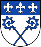
Blazon : "Under a blue shield head, in it three silver lilies, in silver two crossed blue crooks."
See also
literature
- Literature about Dintesheim in the Rhineland-Palatinate state bibliography
Web links
Individual evidence
- ↑ State Statistical Office of Rhineland-Palatinate - population status 2019, districts, communities, association communities ( help on this ).
- ^ The Regional Returning Officer RLP: City Council Election 2019 Dintesheim. Retrieved September 7, 2019 .
- ↑ The regional returning officer RLP: direct elections 2019. see Alzey-Land, Verbandsgemeinde, seventh line of results. Retrieved September 7, 2019 .


