Bermersheim
| coat of arms | Germany map | |
|---|---|---|

|
Coordinates: 49 ° 41 ′ N , 8 ° 13 ′ E |
|
| Basic data | ||
| State : | Rhineland-Palatinate | |
| County : | Alzey-Worms | |
| Association municipality : | Wonnegau | |
| Height : | 175 m above sea level NHN | |
| Area : | 2.32 km 2 | |
| Residents: | 338 (Dec. 31, 2019) | |
| Population density : | 146 inhabitants per km 2 | |
| Postal code : | 67593 | |
| Area code : | 06244 | |
| License plate : | AZ | |
| Community key : | 07 3 31 009 | |
| Association administration address: | Am Schneller 3 67574 Osthofen |
|
| Website : | ||
| Local Mayor : | Andreas Obenauer | |
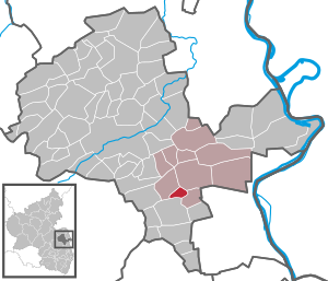
| Location of the local community of Bermersheim in the Alzey-Worms district | ||
Bermersheim is a municipality in the Alzey-Worms district in Rhineland-Palatinate . It belongs to the Wonnegau community . Bermersheim is a wine-growing community in Rheinhessen .
geography
Bermersheim can be reached via the Gundersheim motorway junction on the A 61 or by public transport from Worms .
The neighboring communities clockwise: Westhofen , Gundheim , Flörsheim-Dalsheim and Gundersheim.
history
Bermersheim in Wormsgau was first mentioned in a document from Lorsch Abbey from 780. The place originally belonged to the Counts of Leiningen , who granted the rights in the village as a fief . In the 15th century, the Nagel von Dirmstein family owned the bailiwick and patronage rights . Dieter Nagel sold both to the Elector Friedrich I in 1464 , the rights of the Leininger went to Electoral Palatinate in 1468 . With regard to the jurisdiction of lower jurisdiction , the place was assigned to the Dalsheim mayor's office belonging to the Alzey district . Around 1780 the district contained 621 acres of fields and 30 acres of “ Wingerte ”, 39 houses were counted.
In the First Coalition War , French revolutionary troops took the Left Bank of the Rhine in 1794. from 1798 to 1814 Bermersheim belonged to the canton of Pfeddersheim in the Donnersberg department . As a result of the agreements made at the Congress of Vienna (1815), the region and with it Bermersheim became part of the province of Rheinhessen in the Grand Duchy of Hesse in 1816 .
- Population development
The development of the population of Bermersheim, the values from 1871 to 1987 are based on censuses:
|
|
politics
Municipal council
The council in Bermersheim consists of eight council members, who in the local elections on May 26, 2019 in a majority vote were elected, and the honorary mayor as chairman. In the previous elections, a personalized proportional representation was used as there were several lists to choose from.
The distribution of seats in the municipal council:
| choice | SPD | FDP | FWG | total |
|---|---|---|---|---|
| 2019 | by majority vote | 8 seats | ||
| 2014 | 2 | 3 | 3 | 8 seats |
| 2009 | 2 | 3 | 3 | 8 seats |
| 2004 | 2 | 3 | 3 | 8 seats |
- FWG = Free Voting Group Wonnegau
mayor
The local mayor is Andreas Obenauer. In the local elections on May 26, 2019, he was elected with a share of 76.63% of the votes, making him the successor to Iris Cappel, who had not run for office after 10 years.
coat of arms
| Blazon : "In silver three green ears of corn with a black karst layered across it with a red stem." | |
Natural monuments
Bermersheim is one of the sites in Rheinhessen with about ten million year old mammal remains from the Dinotherien sands of the Ur-Rhine . The term Dinotheriensande is based on the fact that these deposits often contain teeth and bone fragments of the proboscis Dinotherium (also called Deinotherium ).
See also
literature
- Dieter Krienke and Ingrid Westerhoff: Alzey Worms district. Verbandsgemeinden Eich, Monsheim and Wonnegau = monument topography Federal Republic of Germany . Cultural monuments in Rhineland-Palatinate 20.3. Wernersche Verlagsgesellschaft, Worms 2018. ISBN 978-3-88462-379-4 , pp. 189–191.
- Ernst Probst: The Ur-Rhine. Rheinhessen ten million years ago . GRIN, Munich 2009.
- Literature about Bermersheim in the Rhineland-Palatinate State Bibliography
Web links
- Official website of the local community in Bermersheim
- Historical information about Bermersheim at regionalgeschichte.net
Individual evidence
- ↑ a b State Statistical Office of Rhineland-Palatinate - population status 2019, districts, municipalities, association communities ( help on this ).
- ^ Johann Goswin Widder: Attempt of a complete geographical-historical description of the Kurfürstl. Pfalz am Rheine , Third Part, Leipzig 1787, p. 114 ( Google Books )
- ↑ State Statistical Office Rhineland-Palatinate - regional data
- ^ Regional Returning Officer Rhineland-Palatinate: Municipal elections . Retrieved October 28, 2019 .
- ↑ The regional returning officer RLP: direct elections 2019. see Wonnegau, Verbandsgemeinde, second line of results. Retrieved September 8, 2019 .


