
Vendersheim
| coat of arms | Germany map | |
|---|---|---|

|
Coordinates: 49 ° 52 ' N , 8 ° 4' E |
|
| Basic data | ||
| State : | Rhineland-Palatinate | |
| County : | Alzey-Worms | |
| Association municipality : | Wörrstadt | |
| Height : | 217 m above sea level NHN | |
| Area : | 4.17 km 2 | |
| Residents: | 560 (Dec. 31, 2019) | |
| Population density : | 134 inhabitants per km 2 | |
| Postal code : | 55578 | |
| Area code : | 06732 | |
| License plate : | AZ | |
| Community key : | 07 3 31 065 | |
| LOCODE : | DE VDM | |
| Association administration address: | Zum Römergrund 2–6 55286 Wörrstadt |
|
| Website : | ||
| Mayoress : | Elfriede Schmitt-Sieben | |
| Location of the local community of Vendersheim in the Alzey-Worms district | ||
  |
||


Vendersheim [ ˈfɛndərshaim ] is a municipality in the Alzey-Worms district in Rhineland-Palatinate, Germany . It belongs to the Verbandsgemeinde Wörrstadt .
geography
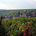
The place lies between Mainz (approx. 28 km) and Alzey (approx. 14 km) in the Rheinhessen region . The highest mountain range in the Palatinate , the Donnersberg , rises in SSW at a distance of 30 km (as the crow flies). Vendersheim is surrounded by vineyards like a horseshoe that opens to the south and has over 1500 hours of sunshine per year. The soil around Vendersheim is very fertile. It consists of weathered loess , the so-called loess loam.
history
After the last ice age and the return of the flora, the permanent settlement of the Rhine valley by band ceramists began . There are only a few finds in the Vendersheim area that would prove settlement in the Bronze Age. During the Roman period, there was a rural Roman settlement in the form of a Roman single farm ( villa rustica ) with agriculture, livestock and viticulture.
The Franks crossed the Rhine border in 406 AD and settled the area between Donnersberg and Rhine. New place names ending with -heim predominate. King Clovis was baptized in 498, the Franks become Christians. In the period that followed, Vendersheim was probably built as a Frankish-Christian settlement.
In 741, the fully free Gunthram and his wife Othruda donated their property in the district of Vendirdisheim to the Fulda monastery . The name means home of Fendiheri (Franconian general, in Old High German fendo "pedestrian, soldier on foot / infantryman"). The form of the name Fendersheim does not appear in a document until 1426 (Koblenz State Archives). The priest Pleban at the St. Martinus Church in Fendersheim was notarized. In 1443 the name "Venderßheim" was finally written down in Hessian documents. The late medieval spelling with V- then prevailed.
In the 15th century Vendersheim belonged to the area of the Junker Faust zu Stromberg. As a result of the Palatinate Reformation , Vendersheim became a Lutheran parish in 1556 and the Martinus Church became a Lutheran church. The Peace of Westphalia of 1648 contained simultaneous provisions for the Electoral Palatinate . Vendersheim became a Simultaneum , d. H. Catholic, Lutheran and Reformed citizens were and remained entitled to reside. Junker Faust became a Catholic in 1660 and the church property in Vendersheim fell to the Catholic Church.
The von Faust family died out in 1730 and Vendersheim fell to the house of the Counts of Eltz , to which it belonged as a sovereign until the end of the 18th century. The Martinus Church became a simultaneous church. Lutherans and Catholics used the same place of worship. With the help of the Counts of Eltz, the Catholic community built the new Martinskirche in 1790/91. The Evangelical Congregation continued to use the old church.
The Left Bank of the Rhine , including Vendersheim, was occupied by French revolutionary troops in 1794 during the First Coalition War. Under French administration, the place belonged from 1798 to 1814 to the canton of Wörrstadt , which was part of the Donnersberg department . The fiefdom law was abolished and birth, marriage and death were subject to official notarization. State schools were set up. Due to the agreements reached at the Congress of Vienna in 1815 and a state treaty concluded in 1816 between Hesse , Austria and Prussia , the region and thus also the municipality of Vendersheim came to the Grand Duchy of Hesse and was assigned to the province of Rheinhessen by this . After the dissolution of the Rhine-Hessian cantons, the place became part of the newly established Alzey district in 1835 .
Lutherans and Reformed people in Rheinhessen united in 1822 to form the Evangelical Church. The dilapidated old Martinus Church was demolished in 1869 and the present Protestant church was built in 1870/71.
- Population development
The development of the population of Vendersheim, the values from 1871 to 1987 are based on censuses:
|
|
politics
Municipal council
The local council in Vendersheim consists of twelve council members, who in the local elections on May 26, 2019 in a majority vote were elected, and the volunteer local mayor as chairman.
mayor
Local mayor is Elfriede Schmitt-Sieben. In the local elections on May 26, 2019, she was confirmed in office with 84.52% of the votes.
coat of arms
Blazon : “Divided by red and gold; above a growing golden lion, below a red paw cross, in the upper left corner decorated with a red and white flag on a red shaft. "
Community partnerships
- Bruley in the Meurthe-et-Moselle department , France , since 1998
Culture and sights
Buildings
- Catholic Church, consecrated in 1790
- Evangelical Church, inauguration: 1871 (November 27)
- Vineyard and observation tower , inauguration: 2015
See also: List of cultural monuments in Vendersheim
Vendersheim photographed from the east

Moonset in May. On the left in the foreground the Catholic. Church, on the right the Protestant church. Looking west.

Vineyard and observation tower west of the village


Regular events
- Vendersheimer Martini Curb (second weekend in November)
economy
Viticulture with a vineyard area of 166 hectares (as of 2010) characterizes the place.
literature
- Literature about Vendersheim in the Rhineland-Palatinate State Bibliography
Web links
- Vendersheim parish
- History of Vendersheim at regionalgeschichte.net
- Local portrait of Vendersheim near Hierzuland , SWR television
Individual evidence
- ↑ a b State Statistical Office of Rhineland-Palatinate - population status 2019, districts, municipalities, association communities ( help on this ).
- ^ Heinrich Steitz: Manuscripts for a chronicle of Vendersheim, Mainz, 1984 (unpublished)
- ↑ State Statistical Office Rhineland-Palatinate - regional data
- ^ The regional returning officer RLP: Municipal council election 2019 Vendersheim. Retrieved September 6, 2019 .
- ^ The Regional Returning Officer RLP: direct elections 2019. see Wörrstadt, Verbandsgemeinde, eleventh result line. Retrieved September 6, 2019 .

Albig | Alsheim | Alzey | Armsheim | Bechenheim | Bechtheim | Bechtolsheim | Bermersheim | Bermersheim vor der Höhe | Biebelnheim | Bornheim | Dintesheim | Dittelsheim-Hessloch | Eckelsheim | Calibration | Ensheim | Eppelsheim | Erbes-Büdesheim | Esselborn | Flomborn | Flonheim | Flörsheim-Dalsheim | Framersheim | Freimersheim | Frettenheim | Gabsheim | Gau-Bickelheim | Gau-Heppenheim | Gau-Odernheim | Gau-Weinheim | Gimbsheim | Gumbsheim | Gundersheim | Gundheim | Hamm am Rhein | Hangen-Weisheim | Hochborn | Hohen-Sülzen | Kettenheim | Lonsheim | Mauchenheim | Mettenheim | Mölsheim | Monsheim | Monzernheim | Mörstadt | Nack | Nieder-Wiesen | Ober-Flörsheim | Offenheim | Offstein | Osthofen | Partenheim | Saulheim | Schornsheim | Siefersheim | Spiesheim | Stein-Bockenheim | Sulzheim | Udenheim | Vendersheim | Wachenheim | Electoral home | Wallertheim | Wendelsheim | Westhofen | Wöllstein | Wonsheim | Wörrstadt