
Zottegem
| Zottegem | |||
|---|---|---|---|

|

|
||
|
|||
| State : |
|
||
| Region : | Flanders | ||
| Province : | East Flanders | ||
| District : | Aalst | ||
| Coordinates : | 50 ° 52 ′ N , 3 ° 49 ′ E | ||
| Area : | 56.66 km² | ||
| Residents: | 26,582 (Jan 1, 2019) | ||
| Population density: | 469 inhabitants per km² | ||
| Post Code: | 9620 | ||
| Prefix: | 09 | ||
| Mayor: | Jenne De Potter ( CD&V ) | ||
Local government address : |
Stadhuis Markt 1 9620 Zottegem |
||
| Website: | www.zottegem.be | ||

Zottegem is a Belgian city in the Denderstreek in the Flanders region . It is located in the province of East Flanders and has a population of 26,582 (as of January 1, 2019). The municipality has a total of eleven sub-municipalities, Elene , Erwetegem , Godveerdegem , Grotenberge , Leeuwergem , Oombergen , Sint-Goriks-Oudenhove , Sint-Maria-Oudenhove , Strijpen , Velzeke-Ruddershove and Zottegem.
The Molenbeek runs through Grotenberge and Leeuwergem and the Molenbeek-Ter Erpenbeek runs through Godveerdegem, Erwetegem and Grotenberge.
location
Geraardsbergen is 11 kilometers south, Oudenaarde 14 km west, Aalst 16 km northeast, Ghent 19 km north-west and Brussels 48 km east.
traffic
In the north and northeast of Wetteren and Erpe-Mere there are motorway exits on the A10 / E 40 .
Zottegem has a regional train station at the intersection of the Kortrijk - Oudenaarde - Zottegem - Denderleeuw - Brussels and Geraardsbergen - Zottegem - Gent railway lines .
photos
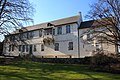
Castle of Count Egmond
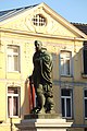
Statue of Count Egmond , market square

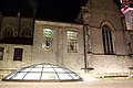
Church of the Assumption of the Virgin Mary, market square

Town hall and statue of Count Egmond , market square
Count Egmond's crypt , market square

St. Andrew's Church in Strijpen

Church in Elene


sons and daughters of the town
- Lamoral of Egmond (1522–1568)
- Koen Barbé (* 1981), racing cyclist
- Jean Blaute (* 1952), guitarist
- Bart De Clercq (* 1986), racing cyclist
- Patricia De Martelaere (1957–2009), writer and philosophy professor
- Ayrton De Pauw (* 1998), cyclist
- Bert Scheirlinckx (* 1974), racing cyclist
- Staf Scheirlinckx (* 1979), racing cyclist
- Rudy Van Snick (* 1956), mountaineer
- Jeroen Van Herzeele (* 1965), jazz musician
Web links
- Official website of the city (Dutch)
Aalst | Aalter | Assenede | Berlare | Beveren | Brakel | Buggenhout | De Pinte | Deinze | Denderleeuw | Dendermonde | Destelbergen | Eeklo | Erpe-Mere | Evergem | Gavere | Ghent | Geraardsbergen | Haaltert | Hamme | Herzele | Horebeke | Caprijke | Kluisbergen | Kruibeke | Kruisem | Laarne | Lebbeke | Lede | Lierde | Lievegem | Lochristi | Lokeren | Maarkedal | Maldegem | Melle | Merelbeke | Moerbeke | Nazareth | Ninove | Ooster cele | Oudenaarde | Ronse | Sint-Gillis-Waas | Sint-Laureins | Sint-Lievens-Houtem | Sint-Martens-Latem | Sint-Niklaas | Stekene | Temse | Waasmunster | Wachtebeke | Wetteren | Wichelen | Wortegem-Petegem | Zele | Zelzate | Zottegem | Zulte | Zwalm