
Vatican City territory


The territory of the Vatican City was established in negotiations between the Holy See and the government of the Kingdom of Italy , which resulted in the signing of the Lateran Treaty (1929). The Vatican City became the smallest state in the world with 0.44 km².
Expansion of the territory
The state territory includes the walled area of the Vatican Hill . It is surrounded by the Roman urban area. On the 0.44 square kilometer area of the Vatican City are the Papal Palace , the St. Peter's Basilica with the St. Peter's Square , the Vatican Museums , the Vatican Gardens , the Governatoratspalast , the barracks of the Swiss Guard and the Vatican gendarmerie , the directorates of the Osservatore Romano and Vatican Radio , a small part of Paul VI's audience hall. as well as other administration buildings.
According to the Lateran Treaties, St. Peter's Basilica and St. Peter's Square remained open to the public. The security of the latter (although part of Vatican territory) is usually carried out by Italian police forces. However, their authority ends at the foot of the stairs that lead towards the basilica. St. Peter's Square can be closed to the public for the duration of special ceremonies. In such cases, and when the Pope is in St. Peter's Square, the Italian police must withdraw from the square into Italian territory.
The border between the Vatican City and Italy is at Campo Santo Teutonico and Paul VI's audience hall. ( western edge of the area outlined in blue on the map ) is not exactly mapped and is recorded differently depending on the source (even on official maps). However, since the Vatican borders on Italian territory in this area, but this is in the extraterritorial possession of the Holy See, this unclear borderline is of no practical relevance. The border of the core area with Italy is 3.2 km.
.jpg&filetimestamp=20100516014301&)
- dark gray: territory of the Vatican City
- light gray ( St. Peter's Square ): territory of the Vatican City, security agendas delegated to Italian security forces.
- red: The narrow strip (about 3 m wide and 60 m long) along the outside of Bernini's northern colonnade is Italian territory according to the Lateran Treaties and is subject to Italian jurisdiction. This fact was disputed by a mixed Vatican-Italian commission, which met until 1932 and specified the technical details of the contracts. However, since this commission was not sent by the Italian side with high-ranking lawyers and, moreover, only had an advisory function, the legal relevance of this position is not recognized by Italy.
- Outlined in blue: The area outlined in blue is Italian territory, but is owned by the Holy See and enjoys extraterritorial status. It is not under Italian jurisdiction. The seat of the Congregation for the Doctrine of the Faith and the greater part of Paul VI's audience hall are located on it . as well as the Campo Santo Teutonico and the German college.
- Other: The light gray area south of the Vatican train station ( stazione ) was colored as "Area on Italian territory to supply the train station" according to the note at the bottom left of the map (this area was not highlighted in light gray in a map of the Gazetta Ufficiale from 1929).
Extra-territorial possessions of the Holy See

In addition to creating the state of Vatican City, the Lateran Treaties also gave the Holy See ownership of several areas and buildings inside and outside Rome .
Many of these areas enjoy special protection, also known as extraterritorial status . However, they are not part of the Vatican territory, but belong to the Italian territory. According to Art. 15 of the Lateran Treaty, their status corresponds to that of the residences of the diplomatic representatives of foreign states, which are specially protected under international law. They are therefore of the Italian jurisdiction principle, not excluded.
Nevertheless, these extra-territorial areas are also under the control and property of the Holy See (as a non-state subject to international law) and have been integrated into the Vatican post and telecommunications system. Public order in the extraterritorial possessions is guaranteed by the Vatican gendarmerie .
The following areas and buildings have extra-territorial status (the list is not exhaustive):
- the patriarchal basilicas of San Giovanni in Laterano , Santa Maria Maggiore and San Paolo fuori le Mura , as well as the adjoining buildings
- the Palace of the Congregation for the Doctrine of the Faith , the greater part of Paul VI's audience hall. as well as the Campo Santo Teutonico and the German College ( Collegio Teutonico di Santa Maria in Campo Santo ) near St. Peter's Basilica
- the Palazzo di Propaganda Fide in the Piazza di Spagna
- the area that the northwest part of the Gianicolo occupies -Hügels, u. a. with the Pontifical Urban University , the Pontifical North America College , the Pontifical Ukrainian College , the Romanian Pontifical Pius College , the Bambino Gesù Children's Hospital and the Sant'Onofrio al Gianicolo Church
- the Palazzo di San Callisto in Trastevere
- the Palazzo della Cancelleria on Corso Vittorio Emanuele II.
- the Palazzo Maffei Marescotti in Pigna
- the papal summer residence in Castel Gandolfo
- the broadcasting center of Radio Vaticano in Santa Maria di Galeria (since 1951)
- the Pontificio Seminario Romano Minore
In addition, any church in Italy where the Pope conducts religious ceremonies and to which the public is not allowed is extraterritorial during this period.
Since the urban planning requirements of the city of Rome or Castel Gandolfo and the needs of the Holy See have changed since the Lateran Treaty came into force, there have been several exchanges of territories or minor corrections in the borderline of the extra-territorial areas since 1929. For example, in 1979 the Palazzo della Dataria near the Quirinal Palace was transferred to the Italian state, which in exchange ceded the Palazzo Pio on Via della Conciliazione to the Holy See.
Summer residence in Castel Gandolfo

The extra-territorial area of the papal summer residence extends over a length of just over 2 km along the crater rim of Lake Albano from Castel Gandolfo to the local area of the neighboring municipality of Albano Laziale . With an area of over 55 hectares, it is larger than the territory of the Vatican City itself. The "Directorate of the Pontifical Villas" ( Direzione delle Ville Pontificie ), a department of the Governorate of the Vatican City , is exclusively responsible for the administration of the area in Castel Gandolfo.
The extra-territorial area consists of three large parts:
- the Apostolic Palace on the Piazza della Libertà, with the gardens known as Giardino del Moro (≈2 ha)
- the garden of Villa Cybo , but without the villa itself, which is separated by the main road (≈3 ha)
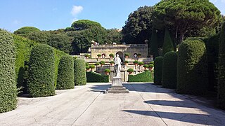
- the Villa Barberini with the associated lands and gardens, the area of the summer residence of the Pontificio Collegio Urbano, the Poor Clare convent in Albano Laziale, as well as agricultural land (≈50 ha)
The Apostolic Palace is connected to the garden of Villa Cybo via a loggia-like crossing, and this in turn via a viaduct with most of the complex, the land around Villa Barberini.
Two smaller areas, also extraterritorial and separated from the main area, are in the municipality of Albano Laziale the olive grove Oliveto ex-Bacelli (≈3 ha) and, on the Piazza della Libertà in Castel Gandolfo, the church of San Tommaso di Villanova by Gian Lorenzo Bernini and the parsonage connected to it (≈ 0.1 ha; with the exception of the post office and pharmacy premises on the ground floor).
The boundaries of the complex have been changed several times since the Lateran Treaty was signed in 1929. So Pius XI. in the 1930s at Albano Laziale Land to set up a small farm that has since supplied the papal court and the Vatican supermarket with goods. In 1947, these newly acquired lands (including the olive grove "ex-Bacelli") were given the status of extraterritoriality together with the adjacent convent of the Poor Clares. In return, the Holy See waived this privilege with regard to the parish cemetery of Albano Laziale (extraterritorial according to the annex of the Lateran Treaties).
Originally, several individual properties scattered across Castel Gandolfo enjoyed the privilege of extraterritoriality - such as the Villa Cybo (separated from its gardens by a main street), Casa Pio X or Casa Benedetto XV. The Cortilone or Salita Sant'Antonio, over which the viaduct leads from the gardens of Villa Cybo to the grounds of Villa Barberini, were extraterritorial, but publicly accessible, traffic areas. When the municipality of Albano Laziale wanted to expand the municipal cemetery, the opportunity arose in 1981 to simplify the drawing of the boundaries of the summer residence. The agreement stipulated that the Holy See would transfer an approximately 2000 m² plot of land bordering the cemetery to the community free of charge, and that it waived the extra-territorial status of the individual properties and publicly accessible traffic areas under its control. In return, the Italian government agreed to grant the area of the summer residence of the Pontificio Collegio Urbano (including gardens) the privilege of extraterritoriality.
- Extra-territorial area of the Holy See in Castel Gandolfo

Papal Palace

Parish Church of San Tommaso da Villanova

Villa Barberini
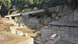
Theater of the villa of Emperor Domitian
Piazzale Quadrato in the gardens of Villa Barberini

Belvedere garden in the gardens of Villa Barberini

Mirror garden in the gardens of Villa Barberini


Lateran Treaties: negotiations on the extension of the territory
In the negotiations that finally resulted in the conclusion of the Lateran Treaty, the question of the expansion of the future state was discussed by both sides. In the early phase of the discussion (1926) the integration of the Villa Doria Pamphili (about 2 km south of the Vatican City) into the state territory in the room (including a connection with the Vatican City via the Villa Abamelek ). Many cardinals of the Curia viewed this proposal with skepticism, since they feared excessive administrative problems if the future state expanded too much.
Web links
- Map of the extraterritorial areas on OpenStreetMap
- Inter Sanctam Sedem et Italiae Regnum Conventiones initae the 11 February 1929 (text of the Lateran Treaties) (Italian) on the Holy See website
- List of some laws of the State of Vatican City on the Vatican City State website
- List of extraterritorial areas (in Italian)
Individual evidence
- ↑ Getting to know the Vatican gendarmerie ( English ) Zenit . September 30, 2014. Retrieved November 10, 2014.
- ↑ www.cia.gov CIA World Factbook.Retrieved July 28, 2009
- ^ German translation of the Lateran Treaty , quoted from Friedrich Berber, Völkerrecht Dokumentensammlung Volume I. Friedensrecht , accessed on November 22, 2014.
- ↑ Basic concepts of law. International law. Lexicon of central terms and topics. Burkhard Schöbner (Ed.) , Page 142
- ^ Zone extraterritoriali vaticani ( Italian ) Sala Stampa della Santa Sede. April 3, 2001. Retrieved June 2, 2008.
- ^ Directorate of the Pontifical Villas . Vatican City State. Retrieved March 12, 2013.


.jpg&filetimestamp=20100516014301)
Historic city centers:
Assisi (with basilica , Sacro Convento and memorials of St. Francis) (2000) |
Florence (1982) |
Mantua and Sabbioneta (2008) |
Naples (1995) |
Pienza (1996) |
Rome (1980) |
San Gimignano (1990) |
Siena (1995) |
Urbino (1998) |
Verona (2000) |
Vicenza (with Palladio's villas in Veneto) (1994)
Buildings:
Arab-Norman Palermo and the cathedrals of Cefalù and Monreale (2015) |
Padua Botanical Garden (1997) |
Castel del Monte (1995) |
Crespi d'Adda (1995) | Early Christian Monuments of Ravenna (1996) |
Modena Cathedral , Bell Tower and Piazza Grande (1997) |
Strade Nuove and Palazzi dei Rolli in Genoa (2006) |
Ivrea , industrial city of the 20th century (2018) |
Centers of Power of the Lombards (2011) |
18th century palace of Caserta with park , the Vanvitelli aqueduct and San Leucio (1997) |
Piazza del Duomo in Pisa (1987) |
Residences of the Royal House of Savoy (1997) |
Sacri Monti in Piedmont and Lombardy (2003) |
Santa Maria delle Grazie with Leonardo da Vinci's “Last Supper” in Milan (1980) | The Sassi and the Park of the Rock Churches of Matera (1993) |
Trulli of Alberobello (1996) |
Villa d'Este in Tivoli (2001) |
Medici Villas and Gardens in Tuscany (2013) |
Venetian Defense System of the 16th to 17th Centuries (2017)
Archaeological sites:
Agrigento (1997) |
Aquileia (with Basilica of the Patriarch ) (1998) | Etruscan necropolis of Cerveteri and Tarquinia (2004) |
Valcamonica rock art (1979) |
Pompeii , Herculaneum and Torre Annunziata (1997) |
Prehistoric pile dwellings around the Alps (2011) |
Su Nuraxi di Barumini (1997) |
Syracuse and the rock necropolis of Pantalica (2005) |
Villa Adriana (1999) |
Villa Romana del Casale (1997)
Cultural and natural landscapes:
Old beech forests and primeval beech forests of the Carpathian Mountains and other regions of Europe (2017, N) |
Amalfi Coast (1997, K) |
Aeolian Islands (2000, N) |
Etna (2013, N) |
Cilento and Vallo di Diano with Elea , Paestum and the Charterhouse of Padula (1997, K) |
Dolomites (2009, N) |
Ferrara and the Po Delta (1995, K) |
Monte San Giorgio (2010, N) |
Portovenere and Cinque Terre with the islands of Palmaria , Tino and Tinetto (1997, K) |
Rhaetian Railway in the Albula / Bernina landscape (2008, K) |
Late baroque towns in Val di Noto (2002, K) |
Val d'Orcia (2004, K) |
Venice and its lagoon (1987, K) | Wine-growing regions in Piedmont: Langhe , Roero and Monferrato (2014, K)
Independent States:
Albania |
Andorra |
Belgium |
Bosnia and Herzegovina |
Bulgaria |
Denmark |
Germany |
Estonia |
Finland |
France |
Greece |
Ireland |
Iceland |
Italy |
Croatia |
Latvia |
Liechtenstein |
Lithuania |
Luxembourg |
Malta |
Moldova |
Monaco |
Montenegro |
Netherlands |
North Macedonia |
Norway |
Austria |
Poland |
Portugal |
Romania |
Russia |
San Marino |
Sweden |
Switzerland |
Serbia |
Slovakia |
Slovenia |
Spain |
Czech Republic |
Turkey |
Ukraine |
Hungary |
Vatican City |
United Kingdom |
Belarus
Dependent areas:
Åland |
Faroe Islands |
Gibraltar |
Guernsey |
Isle of Man |
jersey
Disputed Territories:
Kosovo |
Transnistria
Geography of the States of:
Africa |
Asia |
Europe |
North America |
Oceania |
South America