Flieth-Stegelitz
| coat of arms | Germany map | |
|---|---|---|

|
Coordinates: 53 ° 10 ′ N , 13 ° 49 ′ E |
|
| Basic data | ||
| State : | Brandenburg | |
| County : | Uckermark | |
| Office : | Gerswalde | |
| Height : | 41 m above sea level NHN | |
| Area : | 46.94 km 2 | |
| Residents: | 531 (Dec. 31, 2019) | |
| Population density : | 11 inhabitants per km 2 | |
| Postal code : | 17268 | |
| Area code : | 039887 | |
| License plate : | UM, ANG, PZ, SDT, TP | |
| Community key : | 12 0 73 157 | |
| Office administration address: | Village center 14a 17268 Gerswalde |
|
| Website : | ||
| Mayoress : | Mariechen Piesker | |
| Location of the municipality of Flieth-Stegelitz in the Uckermark district | ||
Flieth-Stegelitz is a municipality in the Uckermark district in Brandenburg, Germany. It is administered by the Gerswalde Office based in the municipality of the same name .
geography
The municipality of Flieth-Stegelitz in the northeast of Brandenburg is located in the hilly and lake landscape of the Uckermark region, which was shaped by the Ice Age . The southern part of the Oberuckersee , through which the Ucker flows , belongs to the municipality, which lies entirely in the Schorfheide-Chorin biosphere reserve . The hilly area reaches 100 m above sea level near the Hessenhagen district. NHN . In the south, the community has a share in the Suckower Forest , an extensive forest area that extends to the northern foothills of the Schorfheide . The closest cities are Prenzlau , Angermünde and Templin .
Community structure
- Inhabited parts of the community
- Africa (Hessenhagener Mühle)
- Flieth
- Hessenhagen
- Pentecost Mountain
- Stegelitz
- Suckow
- Vossberg
- Living spaces
- At Pfingstberger Damm
- Gatekeeper houses
- Forestry Neuland
- Schifferhof
history
Flieth and Stegelitz belonged to the Templin district in the Prussian province of Brandenburg since 1817 and to the Templin district in the GDR district of Neubrandenburg from 1952 . Since 1993 the places have been in the Brandenburg district of Uckermark.
The municipality of Flieth-Stegelitz was created on December 31, 2001 from the merger of the previously independent municipalities of Flieth and Stegelitz.
Flieth
In 1269 the place appears as "Vlete" in a document. The Fliether Church originated from this time and was destroyed in a bomb attack in 1945 except for the surrounding walls and one of three bells.
The village was owned by the von Stegelitz family until the middle of the 15th century , after which the Arnim ruled over what is now called "Fleyth" until 1928.
Stegelitz
As Flieth first mentioned in 1269, the place name probably goes back to the founder Heinrich von Stegelitz . From the end of the 15th century, the rulership of the village changed several times. After the Thirty Years War, Stegelitz was a desert and was gradually repopulated in the following decades. In 1734 - there are now 301 inhabitants - the manor village belonged to the von Arnim family . At that time there was next to a sheep farm, a forester's farm and the village pitcher, a wind mill and a water mill (at the Mühlengraben - the actual upper Ucker ). Some craftsmen were also based in Stegelitz ( linen weavers , bricklayers, carpenters, blacksmiths, saddlers and tailors).
Shortly before the end of the war in 1945, the manor building was set on fire, barns, stables and farm buildings, as well as the church and school, were badly damaged.
The stone church of Stegelitz, evangelical since the Reformation, dates from the second half of the 13th century. The sacred building was built as a hall and originally ended with a flat ceiling. The interior was changed at the end of the 16th century by the installation of two octagonal pillars to form a two-aisled hall and provided with a ribbed vault that is unique for the Uckermark. In the years 1721 to 1737 the church was changed again. The tower top is from 1734. The altar top from 1598 has been preserved in the original color. The pulpit and the patron's box date from 1728. The box stalls for church visitors have been completely preserved. In 1734 General Field Marshal Georg Abraham von Arnim had a grave memorial erected for himself in the church. The church was closed in 2015 due to acute danger of collapse. A development association has been trying to preserve the church since 2017.
In 1991 the school next to the church, built in 1786, was closed. Today it is used as a guest house and seminar center.
In 1948, war refugees settled in the Hessenhagener Mühle residential area 2 km southwest of Stegelitz . They dug holes in the ground for lack of building materials. The long-established inhabitants of the area called the settlement Africa . Later four new farmer's houses were built there, three of which are half-timbered houses, which are still standing today.
Other parts of the community
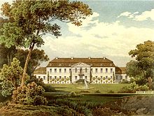
- Suckow - first mentioned in 1206 (as "Sukowe"), was a manor of the von Arnim family from 1577 to 1927 . The baroque Suckower Castle, built by Field Marshal Georg Abraham von Arnim in 1734, fell victim to the flames in 1945. It had two cavalier houses, one of which, the former orangery with a precious library, burned down in the 19th century. The castle had a rococo hall paneled in white with gold, an ancestral hall with stucco chimneys, numerous old furniture and good paintings.
- Vossberg - laid out as a Vorwerk and first mentioned in a document in 1822.
- Pfingstberg - a Vorwerk of Stegelitz that was populated by Westphalia at the beginning of the 18th century. Today, Pfingstberg is the best-known place in the community thanks to the motorway connection of the same name ( A 11 ).
- Hessenhagen - former village on the Pomeranian-Brandenburg border, mentioned in a document in 1269. The village lay desolate between the end of the 15th century and the 18th century.
Population development
| year | Flieth | Stegelitz | year | Flieth-Stegelitz | year | Flieth-Stegelitz | ||
|---|---|---|---|---|---|---|---|---|
| 1875 | 447 | 791 | 2001 | 748 | 2015 | 546 | ||
| 1910 | 434 | 903 | 2005 | 699 | 2016 | 542 | ||
| 1939 | 406 | 571 | 2010 | 631 | 2017 | 536 | ||
| 1946 | 570 | 1 022 | 2011 | 578 | 2018 | 529 | ||
| 1950 | 581 | 1 032 | 2012 | 550 | 2019 | 531 | ||
| 1971 | 517 | 536 | 2013 | 551 | ||||
| 1990 | 387 | 447 | 2014 | 551 | ||||
| 1995 | 344 | 430 | ||||||
| 2000 | 339 | 428 |
Territory of the respective year, number of inhabitants: as of December 31 (from 1991), from 2011 based on the 2011 census
politics
Community representation
The municipal council of Flieth-Stegelitz consists of eight municipal representatives and the honorary mayor. The local election on May 26, 2019 resulted in the following distribution of seats:
| Voter group | Seats |
|---|---|
| Flieth-Stegelitz community of voters | 4th |
| Individual applicant Stefan Vollrath | 1 |
| Individual applicant Matthias Böge | 1 |
| Individual applicant Ronny Krüger | 1 |
| Single applicant Maren Huth | 1 |
mayor
- 2003–2014: Heinz Böttcher
- 2014–2019: Kai Herrmann (SPD)
- since 2019: Mariechen Piesker
In the mayoral election on May 26, 2019, Piesker was elected unopposed candidate with 56.0% of the valid votes for a term of five years.
Attractions
traffic
Flieth-Stegelitz is on the L 24 state roads between Gerswalde and Greiffenberg (district of Angermünde ) and L 241 to Temmen . With the junction Pfingstberg ( A 11 Berlin - Stettin ) Flieth-Stegelitz is connected to the national road network.
The nearest train station is in the neighboring town of Wilmersdorf (part of the city of Angermünde ) on the Berlin – Angermünde – Stralsund railway line . It is served by the regional express line RE 3 Stralsund - Berlin - Elsterwerda-Biehla .
Sons and daughters of the church
- Gustav Heinrich Wagner (1820–1878), classical philologist, high school professor in Ratibor and Königsberg
literature
- Lieselott Enders : Historical local lexicon for Brandenburg, Part VIII, Uckermark , Weimar 1986, ISBN 3-7400-0042-2
Web links
Individual evidence
- ↑ Population in the State of Brandenburg according to municipalities, offices and municipalities not subject to official registration on December 31, 2019 (XLSX file; 223 KB) (updated official population figures) ( help on this ).
- ^ Service portal of the state administration Brandenburg. Flieth-Stegelitz community
- ↑ StBA: Changes in the municipalities in Germany, see 2001
- ^ Georg Dehio: Handbook of German Art Monuments, Brandenburg, Munich a. Berlin 2012.
- ↑ Bettina Vaupel: From inside to outside, in: Monumente, Das Magazin der Deutschen Stiftung Denkmalschutz, 2, 2019, pp. 54–59.
- ↑ Udo von Alvensleben (art historian) , visits before the downfall, aristocratic seats between Altmark and Masuria , compiled from diary entries and edited by Harald von Koenigswald, Frankfurt / M.-Berlin 1968, pp. 240–241
- ↑ Historical municipality register of the state of Brandenburg 1875 to 2005. District Uckermark . Pp. 18-21
- ↑ Population in the state of Brandenburg from 1991 to 2017 according to independent cities, districts and municipalities , Table 7
- ^ Office for Statistics Berlin-Brandenburg (Ed.): Statistical report AI 7, A II 3, A III 3. Population development and population status in the state of Brandenburg (respective editions of the month of December)
- ^ Result of the local election on May 26, 2019
- ↑ Local elections October 26, 2003. Mayoral elections , p. 34
- ^ Result of the mayoral election on June 15, 2014
- ↑ Brandenburg Local Election Act, Section 73 (1)
- ^ Result of the mayoral election on May 26, 2019


