
Hague (Upper Franconia)
| coat of arms | Germany map | |
|---|---|---|
.svg)
|
Coordinates: 49 ° 52 ' N , 11 ° 34' E |
|
| Basic data | ||
| State : | Bavaria | |
| Administrative region : | Upper Franconia | |
| County : | Bayreuth | |
| Management Community : | Cussen | |
| Height : | 485 m above sea level NHN | |
| Area : | 15.89 km 2 | |
| Residents: | 954 (Dec. 31, 2019) | |
| Population density : | 60 inhabitants per km 2 | |
| Postal code : | 95473 | |
| Area code : | 09201 | |
| License plate : | BT, EBS , ESB , KEM , MÜB , PEG | |
| Community key : | 09 4 72 146 | |
| Community structure: | 11 districts | |
| Association administration address: | Bahnhofstrasse 11 95473 Hague |
|
| Website : | ||
| First Mayor : | Robert Pensel ( CSU ) | |
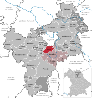
| Location of the municipality of Haag in the Bayreuth district | ||
  |
||


Haag is a municipality and a place in the district of Bayreuth ( administrative district of Upper Franconia ).
geography
location
Haag is embedded in a gentle hilly landscape on the foothills of the Lindenhardt Forest not far from the Rotmain spring . The districts of Obernschreez , Unternschreez and Gosen are located on the slope of the nearby Culmberg or Sophienberg .
Community structure
There are 11 parish parts:
|
There are the districts of Haag, Obernschreez and Unternschreez.
Neighboring communities
Neighboring communities are (starting from the north clockwise): Bayreuth , Creußen and Gesees .
Surname
The place name Haag probably means place enclosed by a forest, bush or hedge. The place name or part of the name Schreez is derived from the Slavic word Sraz and refers to the slope of the Sophienberg, on which the municipality is located.
history
Until the church is planted
The lords of Nankenreuth owned the manor Schreez with Haag and Unternschreez from the 15th century until they died out in 1613. Unterschreez Castle was the former margravial widow's seat . As part of the Prussian principality of Bayreuth since 1792 , Haag fell to France in the Peace of Tilsit in 1807 and became part of Bavaria in 1810 . In the course of the administrative reforms in Bavaria, today's municipality was created with the municipal edict of 1818 .
Incorporations
On May 1, 1978, the community of Schreez, created in 1939 by the amalgamation of the communities of Obernschreez and Unternschreez, was incorporated into Haag. On January 1, 2020, a section with a size of 259 hectares was incorporated from the former community-free area Lindenhardter Forst-Nordwest .


Population development
- 1961: 732 inhabitants
- 1970: 767 inhabitants
- 1987: 783 inhabitants
- 1991: 856 inhabitants
- 1995: 887 inhabitants
- 2000: 905 inhabitants
- 2005: 963 inhabitants
- 2010: 928 inhabitants
- 2015: 952 inhabitants
politics
The community is a member of the Creußen administrative community .
mayor
The first mayor is Robert Pensel (CSU) In 2014, Pensel was elected the new mayor with 90.6%. He had no opponent. Predecessors were Horst Rauh (CSU) until 2014 and Johann Lautner (Free Voting Association) until 2002.
Municipal council
The local elections in 2002, 2008 and 2014 led to the following allocation of seats in the local council :
| 2002 | 2008 | 2014 | |
|---|---|---|---|
| CSU | 2 | 3 | 3 |
| SPD | 2 | 2 | 1 |
| Free voter community Schreez | 2 | 1 | 2 |
| Wahlgemeinschaft Haag | 2 | 2 | 2 |
| total | 8th | 8th | 8th |
coat of arms
|
|
Blazon : “Above a three-mountain quartered by silver and black, split by red and silver; in front a silver poker hook, behind a half black wheel studded with knives. " |
Architectural monuments
The former Gasthaus Stöckel in Unternschreez, whose facade is adorned with a sandstone coat of arms with the annual inscription 1619, was threatened with demolition (as of January 2019). Only the relief is under monument protection, the demolition of the building would have been funded with a 90 percent grant from the “Inside instead of outside” program. In March 2019 it was announced that the house had been sold and should be renovated.
Economy and Infrastructure
Economy including agriculture and forestry
According to official statistics, in 1998 there were no employees at the place of work in the manufacturing industry or in trade and transport who were subject to social insurance contributions. There were a total of 308 employees at the place of residence subject to social security contributions. There were four companies in the manufacturing sector and one in the construction sector. In addition, there were 16 agricultural holdings in 1999 with an agricultural area of 297 hectares, of which 127 hectares were arable land and 170 hectares were permanent green space.
education
The following institutions exist (as of 1999):
- Kindergartens: 25 kindergarten places with 25 children
literature
- Johann Kaspar Bundschuh : Hague . In: Geographical Statistical-Topographical Lexicon of Franconia . tape 2 : El-H . Verlag der Stettinische Buchhandlung, Ulm 1800, DNB 790364298 , OCLC 833753081 , Sp. 450 ( digitized version ).
- Johann Kaspar Bundschuh : Hag . In: Geographical Statistical-Topographical Lexicon of Franconia . tape 2 : El-H . Verlag der Stettinische Buchhandlung, Ulm 1800, DNB 790364298 , OCLC 833753081 , Sp. 461 ( digitized version ).
- Georg Paul Hönn : Hag . In: Lexicon Topographicum of the Franconian Craises . Johann Georg Lochner, Frankfurt and Leipzig 1747, p. 254 ( digitized version ).
Web links
Individual evidence
- ↑ "Data 2" sheet, Statistical Report A1200C 202041 Population of the municipalities, districts and administrative districts 1st quarter 2020 (population based on the 2011 census) ( help ).
- ^ Municipality of Haag in the local database of the Bayerische Landesbibliothek Online . Bayerische Staatsbibliothek, accessed on January 5, 2020.
- ↑ Website of the municipality of Haag ( Memento of the original of April 29, 2011 in the Internet Archive ) Info: The archive link was automatically inserted and not yet checked. Please check the original and archive link according to the instructions and then remove this notice. , accessed on August 23, 2013
- ↑ Nordbayerischer Kurier, August 23, 2013, p. 25.
- ^ Wilhelm Volkert (ed.): Handbook of Bavarian offices, communities and courts 1799–1980 . CH Beck, Munich 1983, ISBN 3-406-09669-7 , p. 432 .
- ^ Federal Statistical Office (ed.): Historical municipality directory for the Federal Republic of Germany. Name, border and key number changes in municipalities, counties and administrative districts from May 27, 1970 to December 31, 1982 . W. Kohlhammer, Stuttgart / Mainz 1983, ISBN 3-17-003263-1 , p. 677 .
- ^ Government of Upper Franconia: Press release no .: 109/19, October 25, 2019: Creußen, Hummeltal, Haag and Gesees are growing; Unregulated areas in the Lindenhardt Forest are being dissolved.
- ↑ Mayor. Municipality of Haag (Upper Franconia), accessed on August 9, 2020 .
- ^ Entry on the coat of arms of Haag (Upper Franconia) in the database of the House of Bavarian History
- ↑ Only the coat of arms must remain in: Nordbayerischer Kurier from January 3, 2019, p. 17.
- ↑ The old restaurant is to become a guesthouse in: Nordbayerischer Kurier of March 21, 2019, p. 21.

Maple Valley | Aufseß | Bad Berneck in the Fichtel Mountains | Betzenstein | Bindlach | Bischofsgrün | Creussen | Eckersdorf | Emtmannsberg | Fichtelberg | Gefrees | Gesees | Glassworks | Goldkronach | Hague | Heinersreuth | Hollfeld | Hummeltal | Church ping garden | Flour chisel | Mistelbach | Mistelgau | Pegnitz | Plankenfels | Plech | Pottenstein | Prebitz | Beak woad | Seybothenreuth | Speicherersdorf | Waischenfeld | Warmensteinach | Willow Hill
Unregulated areas of
Bischofsgrüner Forst |
Fichtelberg |
Forst Neustädtlein am Forst |
Glashüttener Forest |
Heinersreuther Forest |
Neubauer Forest North |
Prüll |
Veldenstein Forest |
Waidacher Forest |
Warmensteinacher Forest North