
Horster Mill (Heinsberg)
| Horster mill
|
||
|---|---|---|
 The Horster mill in Heinsberg-Horst |
||
| Location and history | ||
|
||
| Coordinates | 51 ° 1 '47 " N , 6 ° 10' 44" E | |
| Location | Germany | |
| Waters | Worm , boy worm | |
| Built | 1492 | |
| Shut down | 1958 | |
| technology | ||
| use | Grain and woad mill | |
| Grinder | 1 grind | |
| drive | 1 water wheel | |
| water wheel | undershot | |

The Horster Mühle was a watermill on the Junge Wurm in the city of Heinsberg in the North Rhine-Westphalian district of Heinsberg in the administrative district of Cologne .
geography
The Horster mill had its location on the boys worm , Mühlenteichstraße 9, in the district Horst (Heinsberg) in the town of Heinsberg. The property on which the mill building stood has a height of approx. 50 m above sea level . In front of the mill was a mill pond. Above was the Brünkers mill in Randerath , below is the location of the valley mill in Dremmen .
Waters
The Junge Wurm was a body of water that ran more or less parallel to the Wurm . The junction from the Wurm was in Nirm, a district of the city of Geilenkirchen . Here the worm has a height of 54 m above sea level. The river Junge Wurm, also known as the Kleine Wurm , flowed in a north-northwest direction via Randerath , Horst , Porselen , Dremmen , Grebben , Heinsberg , Kempen and Karken across the German - Dutch border towards Vlodrop and empties at an altitude of 29 m above sea level on Dutch territory into the Rur . It was a natural body of water in which humans had a hand in many places. The Junge Wurm was connected to the Heinsberg moat , the mill canal, the Liecker brook and the mill brook . This composite body of water served for surface drainage and the benefit of the people. For centuries there were around 15 water mills on the Junge Wurm, with a slope of 26 m between Randerath and Karken. With the worm straightening in the 1960s and 1970s, the young worm disappeared from the maps . Instead, drainage channels and trenches were created. The water association Eifel-Rur (WVER) is responsible for the care and maintenance of the water body with a catchment area of 355.518 km 2 .
history
The lordly mill at Horst belonged to the local Fronhof , which was named as early as 1372. The mill was first mentioned in a document from 1492. It was a grinding mill and equipped with a compulsory meal for the places Horst, Porselen and parts of Randerath. In the period from 1500 to the 18th century, the Horster Mühle also had a woad mill , in which a blue color for textile dyeing was obtained from the crushed leaves of the woad plants . With the import of indigo in the 17th / 18th centuries In the 19th century the cultivation of woad was stopped. Around 1800 the Lambertz family took over the Horster mill. In 1958 the milling operation was stopped.
gallery

Horster Mühle, now a residential building

Old millstone at the Horster mill

Today's worm below the Horster mill
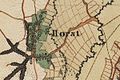
Horst on the first recording from 1846

Horster Mühle on the new recording from 1892

Horst on the tranchot card 1805/1807


literature
- Hans Vogt: Lower Rhine water mill guide 2nd edition. Verein Niederrhein, Krefeld 1998, ISBN 3-00-002906-0 , pages 305-306.
- Elisabeth Nobis-Hilgers: The Miller von Horst , home calendar of the Selfkantkreis Geilenkirchen-Heinsberg. 1957 pages 87-97
See also
Web links
Individual evidence
- ^ German basic map 1: 5000
- ↑ Archive link ( Memento of the original from October 17, 2013 in the Internet Archive ) Info: The archive link was inserted automatically and has not yet been checked. Please check the original and archive link according to the instructions and then remove this notice.
- ↑ http://www.wver.de/
At the worm :
Beeretz mill |
Bommers Mill |
Frelenberger Mill |
Horriger Mill |
Hünshovener oil mill |
Grinder and Oil Mill Trips |
Marienthaler Mill |
Müllendorfer mill |
Lohmühle |
Lohmühle |
Eichenthal Mill |
Mill Hommerschen |
Oil and paper mill Oberbruch |
Porselener Mill |
Randerather oil mill |
Rimburg mills |
Süggerather mill |
Interrupt mill |
Full mill interruption |
Zweibrügger Mühle
An der Junge Wurm:
Aldenhover Mühle |
Brünkers Mill |
Dahlmühle |
Horster mill |
Karker Mill |
Kemper Mill |
Lambertz Mill |
Liecker mill |
Powder mill ] |
Schafhausen grain mill |
Schafhausen oil mill |
Town mill |
Valley mill |
Wolfhager Mühle
Am Rodebach :
Brommler Mühle |
Dahlmühle |
Angel Mill |
Etzenrather mill |
Ingentaler Mill |
Isenbruch Mill |
Istrater mill |
Tüddern grain mill |
Millener mills |
Mohrenmühle |
Square mill |
Vollmühle Tüddern |
Wehrer Mühle
An der Schwalm :
Bischofsmühle |
Post mill |
Kornmühle Tüschenbroich |
Kringsmühle |
Lohmühle |
Neumühle |
Oil mill Tüschenbroich |
Rossmühle |
Wegberger Mühle
Am Mühlenbach :
Buschmühle |
Holtmühle |
Meismühle |
Molz mill |
Schrofmühle
Am Helpensteiner Bach:
Dalheimer Mühle |
Helpensteiner Mill |
Rödgener Mühle
Am Beeckbach :
Ophover Mühle
Am Kitschbach :
Kitscher Mühle
Am Knippertzbach :
Knippertzmühle
Am Uebach :
Übacher Mühle