
Steinbach-Hallenberg
| coat of arms | Germany map | |
|---|---|---|

|
Coordinates: 50 ° 42 ' N , 10 ° 34' E |
|
| Basic data | ||
| State : | Thuringia | |
| County : | Schmalkalden-Meiningen | |
| Height : | 426 m above sea level NHN | |
| Area : | 76.72 km 2 | |
| Residents: | 9575 (Dec. 31, 2019) | |
| Population density : | 125 inhabitants per km 2 | |
| Postal code : | 98587 | |
| Area code : | 036847 | |
| License plate : | SM, MGN | |
| Community key : | 16 0 66 069 | |
| LOCODE : | DE S4G | |
| City structure: | 8 districts | |
City administration address : |
Rathausplatz 2 98587 Steinbach-Hallenberg |
|
| Website : | ||
| Mayor : | Markus Böttcher (pl) | |
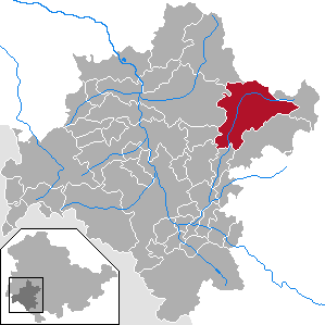
| Location of the town of Steinbach-Hallenberg in the Schmalkalden-Meiningen district | ||
  |
||

Steinbach-Hallenberg is a town in the Schmalkalden-Meiningen district in Thuringia . The city has around 9,000 inhabitants.
geography

The city is located in the Haseltal on the southwest slope of the Thuringian Forest (about 4 km south of the Rennsteig ) at an altitude of about 420 to 470 m. The city's commercial areas are mainly located in Herges-Hallenberg.
City structure
The city is made up of the following districts:
- Altersbach
- Bermbach
- Herges-Hallenberg
- Oberschönau
- Rotterdam
- Steinbach-Hallenberg
- Unterschönau
- Viernau
Neighboring communities
Neighboring communities are Christes , Floh-Seligenthal , Kühndorf , Oberhof , Schmalkalden , Schwarza and Zella-Mehlis .
history

The beginnings of Steinbach-Hallenberg are closely linked to the history of the current Hallenburg ruins . The settlement of the Steinbach-Hallenberger Grund (Haseltal) probably took place since the 12th century. On October 24, 1303, the then sovereign of Schmalkalden Margravine, Anna von Brandenburg, separated the St. Marie chapel in Steinbach from the Schmalkalden mother church. Today's Steinbach-Hallenberg is mentioned for the first time in this document. However, older documented certificates are available from the Hallenburg. This is how Reginhard von Hallenberg is called in 1228. It can be assumed that there was already a settlement under the Hallenburg this year. It is also worth mentioning that the castle is said to have been one of the castles destroyed by Emperor Otto IV in 1212. The dynastic petty rule of the Lords of Haldenberg could even go back to the beginning of the 12th century, as the borderline of the Reinhardsbrunn monastery documents from 1111 allows conclusions to be drawn about a dominion around the Hallenburg.
On July 18, 1595, the municipality of Steinbach unter Hallenberg was granted the right to drink and brew, in June 1669 the market rights and on June 30, 1936 the city rights.
Untersteinbach and Obersteinbach
The town of Steinbach-Hallenberg originally developed from two independent settlements. The map "Warhaffter demolition of the Schmalkalden rule" from 1589 shows Undern Steinbach and Obern Steinbach . Obersteinbach was formed by the settlements at Schlossberg and at the "Burg" (today's Moosburgstrasse). Untersteinbach, on the other hand, developed out of a settlement that existed along the river in the Erbstal. From the 16th century to 1822, both settlements belonged to the Hallenberg office (from 1619 to the Hessian rule Schmalkalden ), from which the double name Steinbach-Hallenberg later emerged.
Second World War
During the Second World War , around 90 men and women from France , the Ukraine and the Netherlands had to do forced labor : in smaller metalworking companies, with baker Arthur Fuchs , with innkeeper Rudolf Waitz , in the Kurt Wilhelm company . At least three women with child died in the living conditions and were in the cemetery in Eichelsbach of Schmalkalden buried.
Territorial and political affiliation
| 12th century – 1228/1232 | dynastic petty rule of the Lords of Hallenberg |
| 1228 / 1232-1274 | County of Henneberg (undivided) |
| 1274-1391 | Grafschaft Henneberg-Hartenberg (between before 1374-1391 pledge of the Lords of Bibra ) |
| 1391-1549 | County of Henneberg (-Aschach) -Römhild (1532–1549 side line Henneberg-Schwarza) |
| 1549-1583 | County of Henneberg-Schleusingen |
| 1583-1619 | Electorate of Saxony |
| 1619-1626 | Landgraviate of Hessen-Kassel |
| 1626-1646 | Lien in Hessen-Darmstadt |
| 1646-1807 | Landgraviate of Hessen-Kassel |
| 1807-1813 | Kingdom of Westphalia (Werra department, Eschwege district) |
| 1813-1866 | Electorate of Hesse |
| 1866-1944 | State of Prussia (Hesse-Nassau province, Kassel district, Schmalkalden district) |
| 1944-1945 | State of Prussia (Province of Saxony, District of Erfurt) |
| 1945–1952 | State of Thuringia (1945–1950 district Schmalkalden, 1950–1952 district Suhl) |
| 1952-1990 | District of Suhl, district of Schmalkalden |
| since 1990 | Free State of Thuringia (1990–1994 district of Schmalkalden, since 1994 district of Schmalkalden-Meiningen) |
Incorporations
The community of Herges-Hallenberg was incorporated in 1978.
As of January 1, 2019, the municipalities of the neighboring Haselgrund administrative community ( Altersbach , Bermbach , Oberschönau , Rotterode , Unterschönau and Viernau ) were incorporated into Steinbach-Hallenberg.
Population development

| year | Residents |
|---|---|
| 1564 | 400 |
| 1647 | 620 |
| 1747 | 1,450 |
| 1773 | 2.011 |
| 1796 | 1.911 |
| 1802 | 2,019 |
| 1828 | 2,426 |
| 1830 | 2,475 |
| 1848 | 2,666 |
| 1875 | 3,000 |
| 1890 | 3,240 |
| 1895 | 3,664 |
| year | Residents |
|---|---|
| 1900 | 4,009 |
| 1933 | 5,978 |
| 1935 | 6,034 |
| 1939 | 6,077 |
| 1946 | 7,010 |
| 1960 | 6,392 |
| 1965 | 6,295 |
| 1974 | 6,242 |
| 1994 | 6.130 |
| 1995 | 6.147 |
| 1996 | 6.152 |
| 1997 | 6.220 |
| 1998 | 6.167 |
| 1999 | 6.168 |
| year | Residents |
|---|---|
| 2000 | 6,149 |
| 2001 | 6,034 |
| 2002 | 5,960 |
| 2003 | 5,868 |
| 2004 | 5,777 |
| 2005 | 5,727 |
| 2006 | 5,620 |
| 2007 | 5,530 |
| 2008 | 5,471 |
| 2009 | 5,414 |
| 2010 | 5,347 |
| 2011 | 5,191 |
| 2012 | 5,084 |
| 2013 | 5,053 |
| year | Residents |
|---|---|
| 2014 | 5,046 |
| 2015 | 5,056 |
| 2016 | 4,965 |
| 2017 | 4,887 |
| 2018 | 4,894 |
politics
mayor
Mayor Markus Böttcher (independent) was elected on April 14, 2019 with 52.8% of the vote.
City council
The local elections on May 25, 2014 with a turnout of 50.3% led to the following distribution of the 20 seats in the city council:

| Party / list | Share of votes | Seats |
| CDU | 49.7% | 10 |
| FDP | 18.4% | 4th |
| The left | 14.8% | 3 |
| SPD | 4.9% | 1 |
| BI / Free Voters | 12.3% | 2 |
coat of arms
Blazon : Divided by blue over red; above, between two green fir trees, a silver castle ruin on a silver rock; Golden hammer and golden blacksmith's tongs crossed diagonally below.
Town twinning
City partnerships exist with the Hessian towns of Steinbach (Taunus) near Frankfurt am Main and Lohra in the Marburg-Biedenkopf district and the North Rhine-Westphalian community of Wilnsdorf .
Culture and sights

The Hallenburg castle ruins, enthroned on an 80 m high porphyry rock as a symbol of the city , are probably one of the most outstanding historical buildings in the city. The late Romanesque castle on the Arnsberg with the 20 m high keep and remains of the core castle was first mentioned in a deed of donation from 1268 as castum Haldenberc .
There is also an early baroque church in Steinbach-Hallenberg, which was built in 1652 and 1698 . The three galleries are decorated with pictures of the biblical story. Also worth mentioning is the pulpit, the work of an unknown Nuremberg master. It was donated to the church by the mayor Hans Happ from Unterschönau in 1658. Also worth seeing is the stone entrance gate of the cemetery from 1605. The upper right keystone contains the names of the village masters (headmasters) and twelve (community representatives) of Steinbach-Hallenberg as well as the mayor of the Hallenberg office. The cemetery chapel was built in 1739.
The “Glockenhaus” local history museum is located on the Schlossberg, a half-timbered house with a substructure from the Middle Ages. It was originally a farm building in the castle district. The museum specialty of the Haselgrund , the metal handicraft museum, arose from the tradition of metal handicrafts . Here and in the small workshops belonging to it, you can watch how nails and the local specialty - corkscrews - were handcrafted. There is still an old, true to original corkscrew workshop on the site of the handicraft museum. The entire building was pulled from its original location on low transporters in 2004 and repositioned there. Every September, on the day of the open monument , the forge festival with demonstrations takes place here.
In addition to many half-timbered houses from the 18th and 19th centuries, the town hall, built in 1900, is also worth mentioning.
The inrun towers and the landing slope of the ski jumping facility in Kanzlersgrund are located in the Steinbach-Hallenberg district.
On yet to district belonging Ruppberg an Outbound castle , Schloss Burg Ruprecht , suspected.
Economy and Infrastructure
Companies and industries
The metalworking industry traditionally predominates in Steinbach-Hallenberg. Today you can find a mix of metal, plastic and wood processing, electrical engineering, cardboard box production, construction and handicraft businesses as well as sales facilities from all areas of retail. The three industrial areas Im Erlich , Am Schertzer and Am Stiller Berg have a total developed area of 35.8 hectares. Steinbach-Hallenberg is a state-approved resort .
Social facilities
In Steinbach-Hallenberg there are two day-care centers, a primary school ( environmental school in Europe ) and a regular school. Both schools were rebuilt away from the center on the Hergeser meadows . There is also a three-field multi-purpose hall with a bowling alley. There is a library opposite the town hall. There is also a post office, an evangelical elderly care center, an ambulance station (DRK KV Schmalkalden eV) and a home for assisted living. Several doctors (general practitioners, ophthalmologists, gynecologists, dentists) and physiotherapists practice in Steinbach-Hallenberg. There are two pharmacies.
traffic
Rail transport
Steinbach-Hallenberg has a train station on the Zella-Mehlis-Wernshausen railway line , from Monday to Friday the South Thuringia Railway runs every hour, and on weekends every two hours.
Trunk roads
Steinbach-Hallenberg can be reached via the motorway 71 via the Suhl / Zella-Mehlis or Oberhof junctions.

Personalities
sons and daughters of the town
- Johann Friedrich Doles (1715–1797), composer and Thomas Cantor
- Georg Rommel (1788–1833), composer
- Hans von Obstfelder (1886–1976), infantry general during World War II
- Otto Recknagel (1897–1983), NSDAP politician, member of the Prussian Landtag and the Reichstag
- Rolf Recknagel (1918–2006), literary scholar
- Werner Usbeck (1920–2007), professor, rector of the Medical Academy in Erfurt and director of the surgical clinic
- Uwe Greßmann (1933–1969), writer
- Hartmut Löwe (* 1935), Protestant theologian and former military bishop of the Bundeswehr
- Helmut Recknagel (* 1937), ski jumper
- Eberhard Häfner (* 1941), writer
- Jürgen Werner (1942–2014), football player
- Volker Wahl (* 1943), archivist and historian
- Manfred Wolf (* 1948), ski jumper
- Siegmar Menz (* 1950), soccer trainer and manager
People connected to the city
- Renate Holland-Moritz (1935–2017), writer, grew up in Steinbach-Hallenberg
- Kati Wilhelm (* 1976), biathlete, grew up here
- Alexander Wolf (* 1978), biathlete, lives in the village
- Florian Menz (* 1994), ski jumper, lives in the village
Honorary citizen
- Werner Usbeck (1920–2007), physician
- Helmut Recknagel (* 1937), ski jumper
- Kati Wilhelm (* 1976), biathlete
literature
- Alexander Köbrich: History of Steinbach and Amt Hallenberg . Self-published, Steinbach-Hallenberg 1894 ( digitized ; reprint published and with an afterword by Volker Wahl . Hubert, Göttingen 2008).
- Volker Wahl: Steinbach-Hallenberg - past and present . Steinbach-Hallenberg City Council, Steinbach-Hallenberg 1978.
- Volker Wahl: A walk through the history of Steinbach-Hallenberg and the surrounding area . Hallenburg-Verlag, Steinbach-Hallenberg 1990.
- Wieland Jung, Wolfgang Diller: Steinbach-Hallenberg - history in pictures . Geiger-Verlag, Horb am Neckar 1993, ISBN 3-89264-803-4 .
- Authors of the Chronicle Working Group: Contributions to the history of Steinbach-Hallenberg - Description of a century from 1900–2000 . City administration Steinbach-Hallenberg, Steinbach-Hallenberg 2003.
Web links
- Official website of the city
- History & genealogy research in Steinbach-Hallenberg and the surrounding area
Individual evidence
- ^ Population of the municipalities from the Thuringian State Office for Statistics ( help on this ).
- ↑ Thuringian Association of the Persecuted of the Nazi Regime - Association of Antifascists and Study Group of German Resistance 1933–1945 (Ed.): Local history guide to sites of resistance and persecution 1933–1945. Volume 8: Thuringia. VAS - Verlag für Akademische Schriften, Frankfurt am Main 2003, ISBN 3-88864-343-0 , pp. 259 f.
- ↑ Thuringian Law and Ordinance Gazette No. 14/2018 p. 795 ff. , Accessed on May 20, 2019
- ^ A b Volker Wahl: History of Steinbach-Hallenberg.
- ↑ a b Data source from 1994: Thuringian State Office for Statistics.
- ↑ Mayoral election 2019 , accessed on May 13, 2019
- ^ Thuringian State Office for Statistics: 2014 municipal council elections - final result in Brotterode-Trusetal .
- ↑ Heinz Göschel (Ed.): Lexicon cities and coats of arms of the German Democratic Republic. 3rd edition, (reprint of the 2nd revised and expanded edition). VEB Bibliographisches Institut, Leipzig 1985.
- ↑ Translocation of the corkscrew workshop ( page can no longer be accessed , search in web archives ) Info: The link was automatically marked as defective. Please check the link according to the instructions and then remove this notice. .

Belrieth | Birx | Breitungen / Werra | Brotterode-Trusetal | Christes | Dillstädt | Einhausen (Thuringia) | Ellingshausen | Erbenhausen | Fambach | Flea Seligenthal | Frankenheim / Rhön | Friedelshausen | Grabfeld | Kaltennordheim | Kühndorf | Leutersdorf (Thuringia) | Mehmels | Meiningen | Neubrunn (Thuringia) | Oberhof | Ober Maßfeld-Grimmenthal | Oberweid | Rhönblick | Rippershausen | Ritschenhausen | Pipe | Pink | Roßdorf (Thuringia) | Schmalkalden | Surge | Schwarza (Thuringian Forest) | Steinbach-Hallenberg | Sülzfeld | Undersize field | Utendorf | Vachdorf | Wasungen | Zella Mehlis