Laz (Finistère)
| Laz | ||
|---|---|---|

|
|
|
| region | Brittany | |
| Department | Finistère | |
| Arrondissement | Chateaulin | |
| Canton | Briec | |
| Community association | Haute Cornouaille | |
| Coordinates | 48 ° 8 ′ N , 3 ° 50 ′ W | |
| height | 31-295 m | |
| surface | 34.44 km 2 | |
| Residents | 661 (January 1, 2017) | |
| Population density | 19 inhabitants / km 2 | |
| Post Code | 29520 | |
| INSEE code | 29122 | |
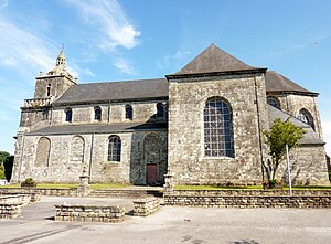
 Saint-Germain and Saint-Louis church |
||
Laz ( Breton Laz ) is a French commune in western Brittany in the Finistère department with 661 inhabitants (as of January 1, 2017). The municipality belongs to the canton of Briec (canton of Châteauneuf-du-Faou until 2015 ).
location
The place is located about 32 kilometers east of the Atlantic coast near the Aulne river and the edge of the Montagnes Noires ridge .
Quimper is 25 kilometers southwest, the city and port of Brest 55 kilometers northwest and Paris around 470 kilometers east (as the crow flies ).
traffic
At Châteaulin , Briec and Rosporden there are exits on the expressway E 60 Brest- Nantes .
In Châteaulin, Quimper and Rosporden hold regional trains on the railway line Brest-Nantes and the train station of Brest is the terminus of the TGV Atlantique to Paris.
The Aéroport de Brest Bretagne regional airport is located near the city of Brest in Guipavas .
Population development
| year | 1962 | 1968 | 1975 | 1982 | 1990 | 1999 | 2010 | 2017 |
| Residents | 1025 | 996 | 863 | 786 | 706 | 694 | 696 | 661 |
| Sources: Cassini and INSEE | ||||||||
Attractions
- Saint-Germain and Saint-Louis church
See also: List of Monuments historiques in Laz (Finistère)
literature
- Le Patrimoine des Communes du Finistère. Flohic Editions, Volume 1, Paris 1998, ISBN 2-84234-039-6 , pp. 238-242.
