
Löhma
| coat of arms | Germany map | |
|---|---|---|

|
Coordinates: 50 ° 37 ' N , 11 ° 51' E |
|
| Basic data | ||
| State : | Thuringia | |
| County : | Saale-Orla district | |
| Management Community : | Lake district | |
| Height : | 430 m above sea level NHN | |
| Area : | 10.46 km 2 | |
| Residents: | 265 (Dec. 31, 2019) | |
| Population density : | 25 inhabitants per km 2 | |
| Postal code : | 07907 | |
| Area code : | 03663 | |
| License plate : | SOK, LBS, PN, SCZ | |
| Community key : | 16 0 75 063 | |
| Association administration address: | Schleizer Str. 17 07907 Oettersdorf |
|
| Website : | ||
| Mayor : | Christian Kolbe | |
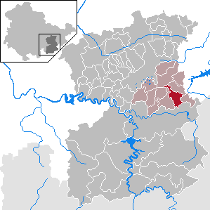
| Location of the community of Löhma in the Saale-Orla district | ||
  |
||


Löhma is a municipality in the Lake District administrative community in the Saale-Orla district in Thuringia .
geography
North of Oettersdorf on a local road to Göschitz and Kirschkau, the place lies on a plateau-like area of the Thuringian slate mountains . To the east this area is flanked by a wooded ridge.
Neighboring communities
Neighboring communities are Oettersdorf , Pörmitz , Dittersdorf , Göschitz and Kirschkau .
geology
The soils of the Southeast Thuringian Slate Mountains have a high proportion of fine soil and a high humus content and are therefore fertile under the climatic conditions of the Schleiz region. The enclosed Güldequelle delivers 600,000 liters of water at a constant temperature of around 11 degrees Celsius per day.
history
Löhma was first mentioned in a document under the name Lomen in 1355. The German Order founded soon after 1240, the first chapel on the spot. Instead of the previous medieval building from the 14th century, a hall church was built in 1710 .
There used to be a castle on the site of the later manor. In the former moat of the current village pond there are still remnants of the wall.
The site of the former rust mill is located 600 meters below the Gülde spring . In 1616 it was mentioned for the first time with the neighboring Löhmaer Railamühle in a registration of men of military age from the Schleiz office . Each mill was equipped with an agricultural property for further feeding of the owners. After the end of the grinding operation in the rust mill, the owner of LPG Oettersdorf joined. In 1992 a citizen from Schleiz bought the property for private use. During the GDR era, the Railamühle was a children's holiday camp run by the baked goods combine from Berlin . As early as 1953, when the property was sold, the mill was declared closed, and then children's voices rang through the valley. A planned holiday and hotel operation was not implemented. After a long vacancy, the owner changed in 2000.
Löhma was and is an agricultural place.
Population development
Development of the population (December 31) :
|
|
|
|
|
- Data source: Thuringian State Office for Statistics
Personalities
- Christoph Ernst von Beulwitz (1695–1757), Schwarzburg-Rudolstadt Privy Councilor and Chancellor in the Danish service, was born in Löhma
- Klaus Renft (1942-2006), musician, (Klaus Renft Combo), lived in Löhma until his death
Individual evidence
- ^ Population of the municipalities from the Thuringian State Office for Statistics ( help on this ).
- ↑ Löhma. Administrative community "Seenplatte", June 10, 2015, accessed on October 18, 2015 .
- ↑ Manfred Graf: Organization of the cooperative plant production with a high proportion of grassland in the southeast Thuringian slate mountains. Shown at the KOG "Lobenstein". 1970, (Jena, University, dissertation, 1970; typed).
- ↑ Michael Köhler: Thuringian castles and fortified prehistoric and early historical living spaces. Jenzig-Verlag Köhler, Jena 2001, ISBN 3-910141-43-9 , p. 57.
- ↑ Günter Steiniger: Mills on the Auma, the Triebes, the Leuba and in the Güldetal. With the mills at Kesselbach, Finkenbach, Pöllnitzbach, Struthbach, Floßbach and the. Rockstuhl, Bad Langensalza 2011, ISBN 978-3-86777-296-9 , pp. 202-205.
Web links
Bad Lobenstein | Bodelwitz | Dittersdorf | Döbritz | Dreitzsch | Eßbach | Gefell | Geroda | Gertewitz | Görkwitz | Göschitz | Gössitz | Grobengereuth | Hirschberg | Keila | Cherry chew | Kospoda | Krölpa | Langenorla | Lausnitz | Lemnitz | Löhma | Miesitz | Mittelpöllnitz | Moßbach | Moxa | Neundorf (near Schleiz) | Neustadt an der Orla | Nimritz | Oberoppurg | Oettersdorf | Oppurg | Paska | Peuschen | Plot | Pörmitz | Pößneck | Quaschwitz | Ranis | Remptendorf | Rosendorf | Rosenthal am Rennsteig | Saalburg-Ebersdorf | Schleiz | Lubricating seat | Schmorda | Schondorf | Seisla | Solkwitz | Tanna | Tegau | Tommelsdorf | Triptis | Volkmannsdorf | Weira | Wernburg | Wilhelmsdorf | Wurzbach | Ziegenrück