Macedonia (geographic region of Greece)
|
Μακεδονία Macedonia |
|
|---|---|

|
|
| Basic data | |
| State : | Greece |
| Regions : |
East Macedonia and Thrace West Macedonia Central Macedonia |
| Surface: | 34,178 km² |
| Residents: | 2,853,000 (2015) |
| Population density: | 83.47 inhabitants / km² (2015) |
| Capital : | Thessaloniki |
| FIPS code | GR-MAK |
| Website : | Website of the Greek Ministry for Macedonia and Thrace ( Memento of May 3, 2015 in the Internet Archive ) |
Macedonia ( Greek Μακεδονία Makedonía ) or Macedonia , also Aegean Macedonia ( Macedonian Егејска Македонија ) or South Macedonia , is a geographical region in northern Greece that includes that part of the 'historical' Macedonia that is in present-day Greece.
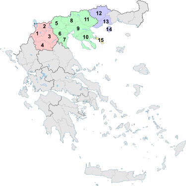
Administratively, the region consists of all regional districts of the regions of West Macedonia and Central Macedonia , the three western regional districts of the region of East Macedonia and Thrace, and the autonomous monastic republic of Athos .
The largest city and at the same time the economic and cultural center of Macedonia is Thessaloniki .
geography
Macedonia is the largest geographic region in Greece with an area of 34,178 square kilometers. It borders in the north on the states of Albania , North Macedonia and Bulgaria . In the west it borders on the Epirus region and in the south on Thessaly . In the east, Macedonia borders Greek Thrace on the Nestos River . The south of Macedonia is formed by the coast of the Aegean Sea and the island of Thasos .
The largest plain in Greece is on the territory of Macedonia.
climate
The climate in Macedonia is generally continental and Mediterranean on the coasts. In contrast to the other regions of Greece, the winter in Macedonia is relatively cool and rich in rainfall. Spring and summer are warm, with many hours of sunshine (over 2000 annually) and little rainfall.
population
Macedonia is home to 2,853,000 inhabitants. This corresponds to a population density of 83.47 inhabitants per square kilometer.
The composition of the population in Macedonia is the result of several radical resettlements, especially in the 20th century, which mostly took place according to religious affiliation. In addition to emigration overseas from the middle of the 19th century - after the fire in Thessaloniki in 1917 also to Palestine - it was mainly wars that triggered the population movements. The approximately 100,000 Slavic-speaking members of the Bulgarian Exarchate were expelled to Bulgaria after the Balkan Wars according to a convention attached to the Treaty of Neuilly-sur-Seine in 1919 (the Romanian- and Slavic-speaking followers of the Patriarchate of Constantinople remained in the country as " Greeks "); an estimated 380,000 Muslims (Turks, Slavs, Megleno-Romanians and Roma) were resettled to Turkey as a result of the population exchange under the Lausanne Convention of 1923. Around 640,000 Greek Orthodox (Greek and Turkish speaking) refugees from Turkey - Asians Minor, Thracians, Pontic Greeks and Cappadocians - were settled in Macedonia. Around 50,000 Ladino-speaking Jews from Macedonia, most of them from Thessaloniki , were deported to German extermination camps and murdered by the German and Bulgarian occupation in 1943. During the Greek Civil War that followed World War II , many communist residents of Macedonia, mainly Slavs, fled to Yugoslavia and other Eastern Bloc countries . A second immigration from the states of the collapsed Soviet Union took place in the 1990s.
At the beginning of the 21st century, the overwhelming majority of modern Greek was spoken in Macedonia , although a considerable number of the descendants of the refugees (Greek prosfyges πρόσφυγες) retained the Greek dialects from Anatolia, especially Pontic . The "locals" (Greek dopii ντόπιοι) are descendants of the Greek, Slavic and Meglenoromanian Greek Orthodox Christians of the 1910s. On minority languages, there are no investigations by the Greek State, studies of the EU , according to the südmazedonischen dialects and were Meglenorumänische around 1990 in some villages still spoken down to younger generations, mainly in the areas prefecture of Florina and Pella. The Turkish was nurmehr in the first and second generation refugees in use. In public life and in schools, however, only Greek is spoken. Furthermore, there are Aromanian, Megleno-Romanian and Armenian populations as well as a few Roma families. The Jewish population of Thessaloniki counts about 1000 souls. Due to immigration from former Soviet areas, Russian and Tashkent Greek are also spoken in some families.
Most of the inhabitants of Macedonia see themselves as Greek Macedonians . In contrast to other regions, Macedonia has a strong identity that is based on historical differences on the one hand, and the competition between Thessaloniki and Athens on the other . Politicians from this region are said to have typically “ Macedonian ” characteristics.
Population development
|
|
|
The population development in Macedonia was generally characterized by a steady increase between 1920 and 1940 and between 1951 and 2001. In the thirties and forties, the population of Macedonia increased by almost 0.7 million people. In the second half of the 20th century, the population rose again by almost 0.7 million people. In 1975 the population topped the two million mark for the first time.
Overall, in the 100 years between 1912 and 2012, the population of Macedonia grew by almost 1.3 million from 1.2 to 2.5 million people, an increase of almost 110 percent.
Biggest cities
The largest cities in Macedonia are according to the 2001 census.
| rank | Name German | Name greek | Residents |
|---|---|---|---|
| 1 | Thessaloniki | Θεσσαλονίκη | 363,987 |
| 2 | Calamaria | Καλαμαριά | 97,000 |
| 3 | Kavala | Καβάλα | 58,663 |
| 4th | Serres | Σέρρες | 54,266 |
| 5 | Evosmos | Εύοσμος | 52,624 |
| 6th | Katerini | Κατερίνη | 50,510 |
| 7th | Veria | Βέροια | 42,794 |
| 8th | drama | Δράμα | 42,501 |
| 9 | Sykies | Συκιές | 41,726 |
| 10 | Stavroupoli | Σταυρούπολις | 41,653 |
| 11 | Ambelokipi | Αμπελόκηποι | 40,959 |
| 12 | Polichni | Πολίχνη | 36,146 |
| 13 | Kozani | Κοζάνη | 35,242 |
| 14th | Neapoli | Νεάπολη | 30,279 |
| 15th | Ptolemaida | Πτολεμαΐδα | 28,679 |
| 16 | Giannitsa | Γιαννιτσά | 26,296 |
| 17th | Pylea | Πυλαία | 22,744 |
| 18th | Eleftherio-Kordelio | Ελευθέριο-Κορδελιό | 21,630 |
| 19th | Naoussa | Νάουσα | 19,870 |
| 20th | Edessa | Έδεσσα | 18,253 |
| 21st | Kilkis | Κιλκίς | 17,430 |
| 22nd | Menemeni | Μενεμένη | 14,910 |
| 23 | Kastoria | Καστοριά | 14,813 |
| 24 | panorama | Πανόραμα | 14,552 |
| 25th | Florina | Φλώρινα | 14,279 |
| 26th | Alexandria | Αλεξάνδρεια | 13,229 |
| 27 | Triandria | Τριανδρία | 11,289 |
| 28 | Grevena | Γρεβενά | 10.177 |
| 29 | Nea Moudania | Νέα Μουδανιά | 6,475 |
| 30th | Polygyros | Πολύγυρος | 5,040 |
Political structure
Greek Macedonia is divided administratively into three regions (Greek περιφέρειες / periferies, singular περιφέρεια / periferia) with fourteen regional districts (Greek περιφερειακές ενότητες / periferiakés enótites, singular περιφερειακή ενότητα / Periferiaki enótita). The region of East Macedonia and Thrace includes three Macedonian regional districts as well as the three regional districts of the Greek part of Thrace . In addition, the autonomous monastic republic of Athos is located in Macedonia .
Administrative division of Macedonia
Administrative reforms in Macedonia
In 1997, with the " Ioannis Kapodistrias Program " (Σχέδιο Καποδίστρια / Schédio Kapodístria), Law No. 2539/1997 was passed on a comprehensive Greece-wide municipal reform, which within Macedonia the number of the previous 144 urban municipalities or cities and 1,038 rural municipalities or municipalities reduced from a total of 1,182 to only 224 and abolished the 28 provinces (eparchíes) . For the term “Dimos”, which previously only included urban communities, the reform meant a change in meaning, as it now also represents the lowest administrative level in rural areas.
With the administrative reform of 2010 , the prefectures were abolished as a regional level and the 224 existing municipalities were merged into 59 municipalities, some of them very large in terms of area. As regional districts, the areas of the former prefectures are only significant for the allocation of seats in the newly created regional councils of the three regions. The island and municipality of Thasos achieved the status of a separate regional district.
history

Early days
The Greek region of Macedonia was settled very early on. In the stalactite cave of Petralona 200,000 year old fossil bones were found, which were ascribed to a late representative of Homo heidelbergensis ; the Neanderthals later emerged from Homo heidelbergensis . In the same cave, remains of ashes from a fire were found that are around 1.0 million years old. It is unclear whether this fire originated by human hands or accidentally.
Antiquity
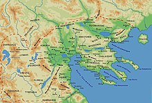
The Ancient Macedonia at the northwest edge of the Aegean was a kingdom and went under King Philip II. (359-336 v. Chr.) On a major power. This ruled almost the entire Balkan Peninsula .
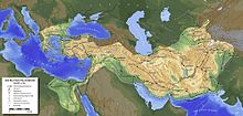
Under Philip's son Alexander, later called the Great (336–323 BC), Macedonia reached the height of its power and its greatest expansion. Under the pretext of a "campaign of revenge" for the Persian invasion of Greece 170 years earlier, he led 334 BC. An all-Greek army to Asia Minor and defeated the Persians in three battles - at Granikos , at Issus and Gaugamela . He conquered Egypt and the Persian heartland one after the other and extended his empire to the Hindu Kush and the Indus . With this he created the conditions for the Hellenization of the whole of the Near East. After Alexander's death in 323 BC Chr. In Babylon disintegrated the empire under the struggles of his successors, the Diadochi .
In 148 BC Chr. Broke the kingdom of Macedonia (Northern Greece) together and came under Roman rule . When the Roman Empire was divided in 395, the province became part of the Byzantine Empire . In 1430 Macedonia came under Ottoman rule.
Modern times
In 1821 Greeks took part in the fighting in Macedonia as part of the Greek War of Independence , but northern Greece remained part of the Ottoman Empire . It was only during the Second Balkan War that Greece was able to win most of Macedonia, which was sanctioned under international law by the Peace of Bucharest in 1913. In the First World War , Macedonia was a war zone ( Salonikifront ). The military camp of Thessaloniki served as the base for the reconquest of Serbia by the Serbian and Entente armies .
Macedonian symbols
Although the Greek Macedonia has no emblems or symbols, the citizens of the region use the golden star of Vergina in blue as a symbol for Macedonia, the folk song Famous Macedonia is considered the “unofficial anthem” of the region.
economy
Macedonia generates around 25% of the Greek gross domestic product (GDP) . The strongest region is Central Macedonia, which contributes 68% to the regional economic output. East Macedonia follows with 20% and West Macedonia with 12% (2010).
Agriculture
Agriculture plays an important role in Macedonia alongside the manufacturing industry.
Winemaking
Main article: Viticulture in Macedonia .
Despite the size of the region, Macedonia, with almost 7,210 hectares of vineyards, is only in third place among the most important growing regions behind Central Greece and the Peloponnese . This is partly due to the topography. In Macedonia, red wine is mainly produced; the most important grape variety is Xinomavro. In some areas, wine is only a minor by-product of the popular Tsipouro pomace brandy .
With the designations of origin Naoussa in Imathia , Amyndeo in Florina , Goumenissa in Kilkis and Côtes de Meliton ( Greek Πλαγιές Μελίτωνα Plagies Melitona ) in Chalkidiki , Macedonia has four of the 25 OPAP wines in Greece.
See also
- Macedonia
- Dispute over the name of Macedonia
- University of Macedonia
- Macedonia Airport
- Portal: Greece
- Greek history
- List of South Slavic names for Greek places
Web links
Individual evidence
- ↑ In addition to the three regional districts of Macedonia, this region also includes the Greek part of Thrace .
- ↑ a b c d e Eurostat - Absolute and relative change in population - NUTS 3 regions. In: appsso.eurostat.ec.europa.eu. May 4, 2015, accessed May 26, 2015 .
- ↑ Information on the geography of Greece ( Memento from June 11, 2009 in the Internet Archive ) Source: Greek Embassy Berlin
- ↑ Figures based on Ioannis Koliopoulos: Macedonia in the turmoil of World War II. in: Ioannis Koliopoulos: History of Macedonia. Thessaloniki 2007, pp. 330-347.
- ^ Entry on the Pontic Greeks in the Encyclopedia of the European East
- ↑ Aleksandr D. Dulienko: Aegean-Macedonian , in: Miloš Okuka (Hrsg.): Lexicon of the languages of the European East . Klagenfurt 2002 ( PDF ( Memento from April 11, 2016 on WebCite ); 174 kB)
- ^ Peter M. Hill: Makedonisch , in: Miloš Okuka (Hrsg.): Lexicon of the languages of the European East . Klagenfurt 2002 ( PDF ( Memento from March 4, 2016 in the Internet Archive ); 462 kB)
- ↑ Riki Van Boeschoten: Usage des langues minoritaires dans les départements de Florina et d'Aridea (Macédoine), Strates [En ligne] 2001, put online on January 11, 2005, accessed on May 7, 2011 (French, online )
- ↑ Petar Atanasov: Aromanian , in: Miloš Okuka (ed.): Lexicon of the languages of the European East . Klagenfurt 2002 ( PDF ( Memento from March 4, 2016 in the Internet Archive ), 197 kB)
- ↑ Pet Atanasov: Megleno-Romanian , in: Miloš Okuka (ed.): Lexicon of the languages of the European East . Klagenfurt 2002 ( PDF ( Memento from March 3, 2016 in the Internet Archive ), 190 kB)
- ↑ Susanne Schwalgin: “We will never forget!” Trauma, memory and identity in the Armenian diaspora in Greece , Bielefeld 2004, ISBN 978-3-89942-228-3
- ↑ The Jews in Greece (PDF; 202 kB), Steven Bowman, University of Cincinnati (engl.)
- ↑ Tom Winnifrith: The Vlachs: History of a Balkan People , London (Duckworth) 1987, ISBN 0-7156-2135-1 , pp. 22-25
- ↑ Απογραφή 1913. Εθνική Στατιστική Υπηρεσία Ελλάδος (ΕΣΥΕ) (Πληθυσμός των νέων χωρών -. Σελ 6) ( Memento of 23 February 2014 Internet Archive )
- ↑ Απογραφή 1920. Εθνική Στατιστική Υπηρεσία Ελλάδος (ΕΣΥΕ) (. - ιδ Σελ / 14 Πραγματικός πληθυσμός) ( Memento of 26 May 2015, Internet Archive )
- ↑ Απογραφή 1928. Εθνική Στατιστική Υπηρεσία Ελλάδος (ΕΣΥΕ) (. - ια Σελ / 11 Πραγματικός πληθυσμός) ( Memento of 26 May 2015, Internet Archive )
- ↑ Απογραφή 1940. Εθνική Στατιστική Υπηρεσία Ελλάδος (ΕΣΥΕ) (. - ε Σελ / 5 Πραγματικός πληθυσμός) ( Memento of 23 February 2014 Internet Archive )
- ↑ Απογραφή 1951. Εθνική Στατιστική Υπηρεσία Ελλάδος (ΕΣΥΕ), (Πραγματικός πληθυσμός - Σελ. 5) ( Memento from May 26, 2015 in the Internet Archive )
- ↑ Απογραφή 1961. Εθνική Στατιστική Υπηρεσία Ελλάδος (ΕΣΥΕ), (Πραγματικός πληθυσμός πληθυσμός - Σελ.15) ( Memento from February 23, 2014 in the Internet Archive )
- ↑ Απογραφή 1971. Εθνική Στατιστική Υπηρεσία Ελλάδος (ΕΣΥΕ), (Πραγματικός πληθυσμός πληθυσμός - Σελ. 15) ( Memento from February 23, 2014 in the Internet Archive )
- ↑ Απογραφή 1981. Εθνική Στατιστική Υπηρεσία Ελλάδος (ΕΣΥΕ), (Πραγματικός πληθυσμός - Σελ. 13) ( Memento from February 23, 2014 in the Internet Archive )
- ↑ Απογραφή 1991. Εθνική Στατιστική Υπηρεσία Ελλάδος (ΕΣΥΕ), (Πραγματικός πληθυσμός - Σελ. 11) ( Memento from February 23, 2014 in the Internet Archive )
- ↑ Απογραφή 2001. Ελληνική Στατιστική Αρχή (ΕΛ.ΣΤΑΤ.), (Πραγματικός πληθυσμός - Σελ. 1)
- ↑ Απογραφή 2011. Ελληνική Στατιστική Αρχή (ΕΛ.ΣΤΑΤ.), (Μόνιμος Πληθυσμός - Σελ. 4) ( Memento from August 17, 2014 in the Internet Archive )
- ↑ 2001 ( Memento from December 1, 2007 in the Internet Archive )
- ↑ The monastic republic of Athos enjoys internal autonomy under the sovereignty of the Greek state .
- ↑ United Nations Group of Experts on Geographical Names: Administrative Division of Greece (Working Paper N ° 95), New York 2000, ( PDF , 1.3 MB)
- ↑ a b Northern Greece relies on cooperation with German companies . In: Germany Trade & Invest . Archived from the original on February 23, 2014. Retrieved March 23, 2014.
Coordinates: 40 ° 45 ' N , 22 ° 54' E


