
Matsumae (Hokkaidō)
| Matsumae-chō 松 前 町 |
|||
|---|---|---|---|
 |
|||
| Geographical location in Japan | |||
|
|||
| Region : | Hokkaidō | ||
| Prefecture : | Hokkaidō | ||
| Coordinates : | 41 ° 26 ' N , 140 ° 7' E | ||
| Basic data | |||
| Surface: | 293.25 km² | ||
| Residents : | 7032 (September 30, 2019) |
||
| Population density : | 24 inhabitants per km² | ||
| Community key : | 01331-5 | ||
| Postal code area : | 049-15xx | ||
| Symbols | |||
| Tree : | jaw | ||
| Flower : | Cherry Blossom | ||
| town hall | |||
| Address : |
Matsumae Town Hall 248 Fukuyama Matsumae -chō, Matsumae-gun Hokkaido 049-1592 |
||
| Website URL: | town.matsumae.hokkaido.jp | ||
| Location of Matsumaes in Hokkaido Prefecture | |||
 |
|||

Matsumae ( Japanese 松 前 町 , - chō ) is a small town in Hokkaidō on the main island of the same name in Japan . It belongs to the Matsumae County of Oshima Sub-prefecture and is the southernmost municipality on the island. With the islands belonging to the municipality, it contains the southernmost and westernmost point of Hokkaidō.
geography
Matsumae extends along the coast of the Sea of Japan , to the south of the Matsumae Peninsula, which forms part of the Oshima Peninsula . Cape Shirakami, the southern tip of the island, is around eight kilometers southeast of the city center. The 1072 m high Daisengen-dake mountain rises about 15 km to the north. Matsumae also includes the volcanic islands of Kojima and Oshima-Ōshima , both of which are uninhabited.
climate
The climate in Matsumae is the mildest in all of Hokkaidō. It is oceanic and shaped by the warm Tsushima current coming from the south. The effective climate classification is Cfa ( east side climate ).
|
Average monthly temperatures and rainfall for Matsumae
|
|||||||||||||||||||||||||||||||||||||||||||||||||||||||||||||||||||||||||||||||||||||||||||||||||||||||||||||||||||||||||||||||||||||||||||||||||||||||||||||||||||||||||||||||||||||||||||||||||||
Neighboring cities and communities
history
In the middle of the 15th century, the Japanese expanded their influence to the southern tip of the island of Ezo, as Hokkaidō was then called. Small groups of settlers established themselves on the Oshima Peninsula ; they lived mainly from fishing and trading with the native Ainu . The Kakizaki family brought the southern tip of the peninsula under their control, founded the Matsumae clan and in 1587 submitted to the supremacy of Toyotomi Hideyoshi , who in return recognized the property claims. As a result, the northernmost castle town in Japan (and the only one on Ezo) was built. It was the administrative center of the Matsumae clan and was called Fukuyama.

For the next two and a half centuries, the Matsumae clan monopolized relations with the Ainu. Tribal leaders were received and traded in a building called the Taikan . Over time, the Matsumae clan gradually expanded their sphere of influence northwards. The gold mining in the surrounding valleys led to water pollution, which the livelihoods of salmon destroyed. This in turn led to famine among the Ainu, as they lived mainly from catching salmon. In addition, there was illegal clearing and overhunting of fur animals. From 1669 to 1672 the Ainu warrior Shakushain led a revolt against the Matsumae clan and advanced almost as far as Fukuyama. It was only when reinforcements arrived from Aomori that the uprising could be put down.

Around 1850 Fukuyama had around 30,000 inhabitants, making it by far the largest city on the island. Matsumae Castle was rebuilt between 1850 and 1854 . During the Boshin War , when imperial troops the supremacy of the Tokugawa - shogunate collapsed, the Matsumae clan behaved initially hesitant. Shogun-loyal troops under the command of Hijikata Toshizō evaded to Ezo and destroyed Matsumae Castle on November 5, 1868, after the occupation had refused to surrender. The city was destroyed by a major fire and could not be rebuilt until April 1869, after imperial troops had reached it. However, it never regained its former importance. With the relocation of the prince's seat to Tate Castle in today's city of Assabu , the Principality (-han) Matsumae was renamed Tate-han. Thus, after the abolition of the Han in 1871 , the city came to the Aomori-ken with the prefecture (-ken) Tate which had arisen from the principality , but in 1872 it became the [prefecture (-dō) ] Hokkai-do or its predecessors. In 1881 the present-day Matsumae district was formed from the previous Tsugaru (-gun) district and part of Fukushima-gun . The modern city (-chō) Fukuyama was formed in 1900 from over 30 pre-modern chō (districts / quarters / streets of an urban settlement). The sub-prefecture (-shichō) Matsumae, which has existed since 1897, was incorporated into the sub-prefecture Hakodate (later renamed Oshima) in 1903. In 1940 the city of Fukuyama was renamed Matsumae. In 1954 the villages (-mura / -son) Ōshima, Ōsawa and Kojima were incorporated - technically as a joint foundation of a new city Matsumae, not as an incorporation in the narrower sense.
Culture
The main attraction are the remains of Matsumae Castle , Japan's northernmost castle. Its keep (tenshu) burned down in 1949 and was replaced by a replica eleven years later. The once extensive castle complex is now a public park with around 10,000 cherry trees . The more than 250 varieties of cherry trees available ensure an unusually long sakura season, which lasts from the end of April to the end of May and attracts numerous tourists.
To the northwest of the park is the temple district with the tombs of the Matsumae daimyos and several Buddhist temples , which are among the oldest on Hokkaidō. Matsumaehan Yashiki is a small historical theme park with replicas of 14 buildings from the Edo period that were typical of Matsumae.
traffic
Matsumae can be reached via National Road 228, which circles the southern tip of the Oshima Peninsula from Hakodate and leads to Esashi . There are also prefecture roads 380, 435 and 607. Hakodate Bus buses operate to Kikonai and Hakodate. The Matsumae line including Matsumae station was shut down in 1988.
photos

Kozenji Temple

town hall
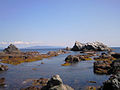
Cape Shirakami
20080920-2.JPG)


Web links
Individual evidence
- ↑ Kokudo Chiriin (English GSI): Extreme points of Japan in latitude and longitude , extreme points of all prefectures and the municipalities (and the districts of the city of Sapporo) in Hokkaidō ( Memento of the original from September 7, 2018 in the Internet Archive ) Info: The archive link was inserted automatically and not yet tested. Please check the original and archive link according to the instructions and then remove this notice. (Japanese; the individual links for each extreme point lead to the GSI online atlas)
- ↑ a b c Matsumae. In: Japan Travel Guide. Yamasa Institute, 2013, accessed June 15, 2017 .
- ↑ Motoo Hinago: Japanese Castles . Kodansha, Tokyo 1986, ISBN 0-87011-766-1 , p. 130-131 .
- ↑ a b Matsumae. japan-guide.com, 2017, accessed June 15, 2017 .
Abashiri | Akabira | Asahikawa | Ashibetsu | Bibai | Chitose | Date | Ebetsu | Eniwa | Fukagawa | Furano | Hakodate | Hokuto | Ishikari | Iwamizawa | Kitahiroshima | Kitami | Kushiro | Mikasa | Mombetsu | Muroran | Nayoro | Nemuro | Noboribetsu | Obihiro | Otaru | Rumoi | Sapporo (administrative headquarters) | Shibetsu | Sunagawa | Takikawa | Tomakomai | Utashinai | Wakkanai | Yūbari
Abashiri-gun : Ōzora | Bihoro | Tsubetsu | Abuta-gun : Toyoura | Tōyako | Niseko | Makkari | Rusutsu | Kimobetsu | Kyogoku | Kutchan | Akan-gun : Tsurui | Akkeshi-gun : Akkeshi | Hamanaka | Ashoro-gun : Ashoro | Rikubetsu | Esashi-gun : Hamatombetsu | Nakatombetsu | Esashi | Furubira-gun : Furubira | Furuu-gun : Tomari | Kamoenai | Futami-gun : Yakumo | Hidaka-gun : Shinhidaka | Hiroo-gun : Taiki | Hiroo | Hiyama-gun : Esashi | Kaminokuni | Assabu | Horoizumi-gun : Erimo | Ishikari-gun : Tōbetsu | Shinshinotsu | Isoya-gun : Rankoshi | Iwanai-gun : Kyōwa | Iwanai | Kabato-gun : Tsukigata | Urausu | Shintotsukawa | Kameda-gun : Nanae | Kamiiso-gun : Shiriuchi | Kikonai | Kamikawa-gun (Ishikari) : Takasu | Higashikagura | Tōma | Pippu | Aibetsu | Kamikawa | Higashikawa | Biei | Kamikawa-gun (Teshio) : Wassamu | Kembuchi | Shimokawa | Kamikawa-gun (Tokachi) : Shintoku | Shimizu | Kasai-gun : Memuro | Nakasatsunai | Sarabetsu | Katō-gun : Otofuke | Shihoro | Kamishihoro | Shikaoi | Kawakami-gun : Shibecha | Teshikaga | Kayabe-gun : Shikabe | Mori | Kudō-gun : Setana | Kushiro-gun : Kushiro | Mashike-gun : Mashike | Matsumae-gun : Matsumae | Fukushima | Menashi-gun : Rausu | Mombetsu-gun : Engaru | Yūbetsu | Takinoue | Okoppe | Nishiokoppe | Ōmu | Nakagawa-gun (Teshio) : Bifuka | Otoineppu | Nakagawa | Nakagawa-gun (Tokachi) : Makubetsu | Ikeda | Toyokoro | Honbetsu | Niikappu-gun : Niikappu | Nishi-gun : Otobe | Notsuke-gun : Betsukai | Okushiri-gun : Okushiri | Rebun-gun : Rebun | Rishiri-gun : Rishiri | Rishirifuji | Rumoi-gun : Obira | Samani-gun : Samani | Saru-gun : Biratori | Hidaka | Setana-gun : Imakane | Shakotan-gun : Shakotan | Shari-gun : Shari | Kiyosato | Koshimizu | Shibetsu-gun : Nakashibetsu | Shibetsu | Shimamaki-gun : Shimamaki | Shiranuka-gun : Shiranuka | Shiraoi-gun : Shiraoi | Sorachi-gun : Kamifurano | Kamisunagawa | Minamifurano | Naie | Nakafurano | Namporo | Sōya-gun : Sarufutsu | Suttsu-gun : Suttsu | Kuromatsunai | Teshio-gun : Embetsu | Teshio | Horonobe | Toyotomi | Tokachi-gun : Urahoro | Tokoro-gun : Kunneppu | Oketo | Saroma | Tomamae-gun : Tomamae | Haboro | Shosambetsu | Urakawa-gun : Urakawa | Uryū-gun : Moseushi | Chippubetsu | Uryū | Hokuryu | Numata | Horokanai | Usu-gun : Sōbetsu | Yamakoshi-gun : Oshamambe | Yoichi-gun : Niki | Yoichi | Akaigawa | Yūbari-gun : Yuni | Naganuma | Kuriyama | Yūfutsu-gun : Abira | Atsuma | Mukawa | Shimukappu